
Zaca Incident Commanders Cautiously Optimistic
Paradise Residents Will Be Allowed To Go Home

At the 12:30 pm news conference held today, Zaca Incident Commanders expressed a cautious optimism that they had turned the corner on the southern flank of the fire. Forty days after the fire began, and after a week in which Santa Barbara residents feared the worst, the leading edge of the fire appears to be turning northeast and into the wilderness.
Much of the credit for this is due to the tireless efforts of the hundreds of fire fighters out on the front line doing the hard work. But credit must also go to the long range planning initiated by the National Incident Management Organization (NIMO) from Boise, currently implemented by the two Type 1 Teams brought in last week.
The effort has not been easy. For the past week, using air attack to protect their backs, fire fighters have used direct line construction and burn out operations to build five miles of containment line from the Peachtree area to Little Pine Mountain.
“This has been a tough five miles,” Mark Schmitt, the county representative on the Incident Management Team explained. “At one point, to finish off the last section on the east side of Little Pine Mountain, we needed to move a crew in place where the only way into the area was by rappelling down fixed ropes from helicopters.
“It was steep country with lots of bluffs, and the only way the crews could get in was by dropping down from the air. We put a line around 95% of the area yesterday and will finish it up today.”
Having contained this section and widened the route down Camuesa Canyon to Indian Creek, Schmitt was very optimistic the back firing planned for Monday could be put on hold. If this is possible it will reduce the final size of the planned back burns quite a bit.
Schmitt continued, “We’re looking at turning the fire along the Don Victor Jeepway. If we can hold this line and move the fire north we may be able to avoid burning out the Mono and Agua Caliente drainages. We’ll know in the next two or three days if we were successful.
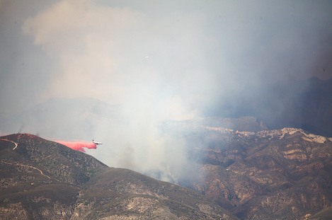
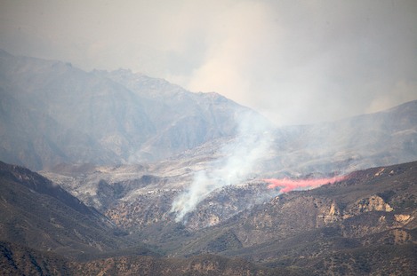
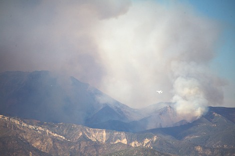
“We’ll use every opportunity to go direct where we can, one foot in the black, one foot on the road. But we need to cool the fire down — and air attack will help us accomplish that.”
Just moments before the conference began, Schmitt announced the DC-10 had made its first drop along the Jeepway and they were hopeful the road could be held. “We’re always playing a game of ‘what ifs,'” he said. “Once we started turning the fire we started asking ourselves, what if we can hold this Jeepway? It would avoid having to burn out quite a bit of territory, possibly as much as 60,000 acres.”
“One of the reasons we could take this opportunity,” Bill Molumby, the other Incident Commander for the Live Oak Team added, “is that we had the plans in place and had done the work needed to establish our primary containment. This made us comfortable that we had the fall back lines in place if things didn’t work out.”
One benefit of this turn of events is that the Paradise Evacuation order was lifted late Sunday and residents will be allowed to return home.
Upper Sisquoc To Be Cordoned Off
Yesterday, the Richardson area commander, Mike Dietrich, received Federal permission to use a dozer in the San Rafael Wilderness down a long ridge near Salisbury Potero. “We’re allowed run the dozer 2.1 miles down the Sweetwater Trail, no more than 1 1/2 blades wide,” Dietrich explained. From there we’re using hand crews to continue the line down to the Sisquoc near the South Fork and from there up to White Ledge Camp.
“Tomorrow we’ll begin burning from Santa Barbara Potrero west along the Sierra Madre ridge to Salisbury, lighting the fire in strategic locations that will take the fire up to the ridge in stages. Once we reach the Sweetwater dozer line we’ll do the same down it, gradually adding more and more black along our containment lines until they are wide enough that anything burning in the middle can’t spot out.”
Dietrich expects this will take 3-4 days to accomplish and includes everything in the upper Sisquoc drainage east of the South Fork, including the Condor Sanctuary, an area in excess of 30,000 acres. This isn’t something he takes lightly. “We’ve done everything else we can at this point,” he explained. “We just can’t let it continue down river.”
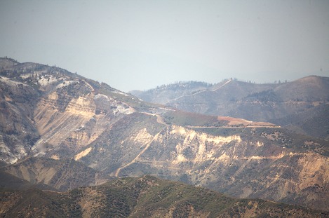
Once the Sisquoc back firing has been accomplished the plan is to turn east and continue building a black line around the main fire perimeter, which is moving both north and south. “The most difficult section we’ll have is the set of switchbacks on Highway 33 north of Pine Mountain,” Dietrich added.
“We’ll start there first and work our way along the highway to Rancho Nuevo Canyon and then follow the OHV route in Tinta Canyon northwest past Cuyama Peak to Santa Barbara Canyon and tie up with our earlier burn.
“Once we’ve done that we should know if Live Oak has been successful in keeping the fire west of the Don Victor Jeepway. If so, we’ll burn along the Jeepway out to Potrero Seco and follow the Don Victor from our end and meet them somewhere in the middle.”
“We expect the perimeters to be pretty black for the first half mile or so in, far enough there’s no way for the fire to escape, but once we’ve accomplished that we’ll work to burn the inside areas in a way that keeps the fire cool.”
Even so, Dietrich expects this will include at least 70,000 acres on this side of the fire perimeter, with 70-80% of it burning at some point over the next few months. “We’ll monitor it constantly until it’s all out,” he added.
Final Thoughts
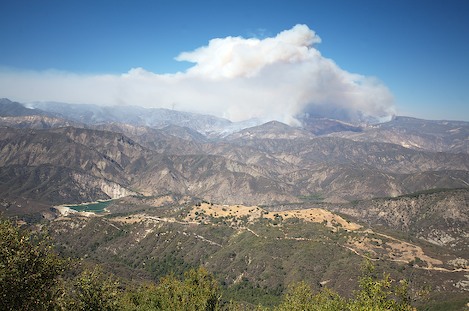
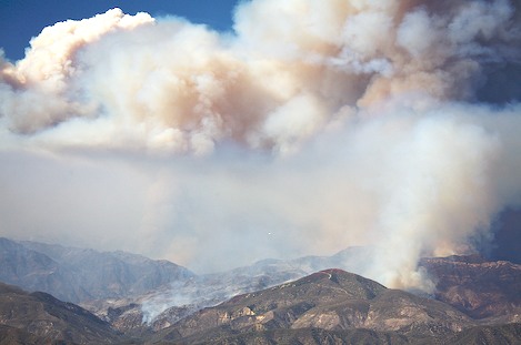
After the press conference I traveled up to the Santa Ynez Mountain crest to check out the fire activity. From town I could see an imposing plume and it appeared things were heating up.
My first impression was that the fire was a long ways off. It was refreshing to see this after watching the plume build earlier in the afternoon and feeling like it was right behind us and just over the crest.
A few minutes of watching the fire led me to a second impression: the fire is distinctly moving north and east in a direction that is getting us out of harm’s way. There is just one small section on the south side of Indian Creek that has active burning and it appears not too difficult to contain.
It also seems the fire is building in intensity and moving towards the far perimeters faster than fire fighters might have expected.
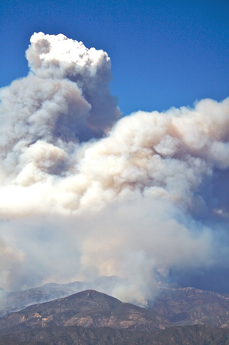
As I watched over the next several hours I could see multiple plumes build into one until the column reached a width in the 4-6 mile range that stretched from Indian Canyon north across the east flanks of Big Pine Mountain to the Alamar and across that drainage through a small window known as the pueto suelo. My impression is that the fire has moved past Madulce Peak and is now entrenched in the Santa Barbara Canyon and Don Victor Valley areas.
The fire is already well beyond the Puerto Suelo, moving rapidly towards the primary containment lines.
And my final thought was although Incident Commanders hoped to contain the fire along the Don Victor Jeepway it has slopped far enough over into Pie Canyon that they will not be able to hold it to the road. There is some good news in that this edge of the fire is moving into a 10-year-old previous fire area – the Ogilvy – and that it may stall out.
Worst case is that the back firing Bill Molumby hopes to avoid may be needed after all.


