• CREATE AN ACCOUNT
  • LOG.IN
  • CONTENTS
  • CLASSIFIEDS
  • ARCHIVE
  • INFO | ADVERTISING | CONTACT US

  • Home
  • News
    • News Main Page
    • NewsFlash
  • A&E
    • A&E Main Page
    • Movie Times
    • TV Listings
    • A&E Blog
    • Art Galleries
    • Best Bets
  • Opinion
    • Opinion Main Page
    • Columns
    • Voices
    • Letters
    • In Memoriam
    • Obituaries
  • Events
    • Today
    • Search
    • Submit
    • Best Bets
  • Living
    • Living Main Page
    • Outdoors
    • Travel
    • Sports
    • Peeps
  • Food & Drink
    • Food & Drink Main Page
    • All Restaurants
    • Delivery
    • All Bars & Clubs
    • Drink Specials
    • Open Now
  • Outdoors
    • Outdoors Main Page
    • Outside Insider
    • Spotlight On
    • Features
  • Classifieds
    • Real Estate
    • Jobs
    • Autos
  • Personals
  • Obits

Kelley Close

Battle to Hold Monte Arido Ridge

Fire Closes in on the Santa Barbara-Ventura County Line
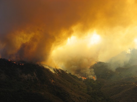
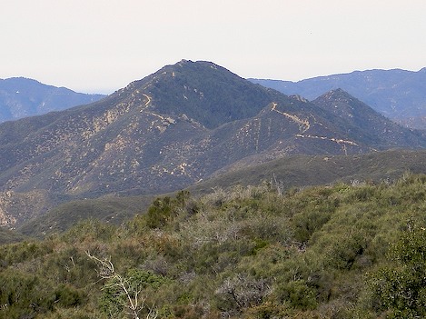
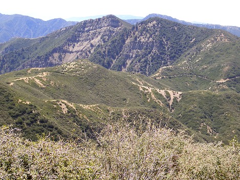

Thursday, August 16, 2007
By Ray Ford (Contact)
Article Tools
Print friendly
E-mail story
Contact an Editor
iPod friendly
Comments
Bookmark This
del.icio.us. del.icio.us.
Digg! Digg!
furl furl
google google
newsvine newsvine
reddit reddit
technorati technorati
Facebook Facebook
Yahoo! My Web 2.0 Yahoo!

Author's Note: Though the fire line continues to move away from Santa Barbara, there is still one critical battle to be played out in a little-known canyon called Agua Caliente. A few will know it as the site of the county's premier hot springs. Wealthy Santa Barbara patron George Owen Knapp discovered the springs a century ago and constructed an elaborate system of pipes from the source down to a small pool where his friends could bathe in the hot essence of the canyon minerals. Beyond the hot springs, the canyon meanders north towards the Hildreth ridge, then east to a high crest known as Monte Arido (the parched mountain) that separates Santa Barbara from Ventura. In its twisted way, the fire has made its way out of Indian Canyon, across Mono Creek and up over Hildreth into Agua Caliente. Over the past 42 days the fire has had its way with Santa Barbara County; soon we will know if Ventura County watersheds will feel its wrath as well.

_________________________

On Monday Incident Commander John Molumby encouraged fire fighters to put everything into the next seventy-two hours. "These are critical hours," he enjoined his troops as they headed out to battle the fire.

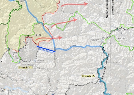
For the past week, the focus has been on holding the Zaca Fire along the north-trending Don Victor Jeepway that separates the Indian Creek and Mono drainages.

Not only would this push the fire away from Santa Barbara, but if they could herd it far enough north past Mono Narrows before it made its way across the drainage, Incident Command hoped it would continue its way northeast up Mono Canyon to a point where it would die out in the face of back fires being set along the Highway 33 and Potrero Seco areas.

Hot shots in Indian Canyon worked feverishly up a 1,500 high ridge to the Don Victor Jeepway and then down into Pie Canyon to cut off the fire from reaching Santa Barbara. Though their efforts were successful, the fire was able to make its way down to the Mono Narrows from further north.

"It's like a red tide," one fire fighter commented, "we catch it in one place and it flows over another ridge further back in the wilderness."

Forest Service

Operations map shows fire's primary direction. Unfortunately, just as hot shot crews had closed off the area directy above Branch VII, the fire crossed over Mono Creek, turned south and moved up towards the Hildreth ridge (noted by the east-west portion of the blue line).

Fire fighters seem to be playing a game of catch up. They invest an extremely hard effort to shore up one location; but it only seems to buy them enough time to take a deep breath and then move on to meet the next crisis.

At this morning's briefing, Incident Commander Mark Schmitt noted that the fire has been marked by "successes followed by setbacks," though he added, "mostly we've had successes and that's due to you [firefighters], who've been out there doing the hard work." Nevertheless, they have not been able to deliver that one last knockout punch.

Yesterday proved Schmitt's point directly: no sooner had the hot shots held the lower Don Victor Jeepway than the fire moved out of upper Indian Canyon, rushed through a series of meadows known as Loma Pelona and down Alamar Creek. By late in the evening the fire had crossed Mono Creek, worked its way up the back side of the 2,500' high Hildreth ridge and was threatening to move down into Agua Caliente Canyon.

With a week's hard work invested in closing what Molumby termed "the back door" in Indian and Pie Canyons, crews should have been celebrating. Instead, they were moving east to deal with the slopovers in Agua Caliente Canyon after it crossed over the Hildreth ridge.

Ray Ford

View looking west along Hildreth Ridge where the battle to hold the fire is currently being played out. The ridge stands 2,500' above the surrounding drainages, extends 5 miles to the west and is critical to hold. This will not be easy; to the left, or south, is Agua Caliente Canyon.

Though the South Coast is not in immediate danger, the fire's presence in the Agua Caliente drainage poses a number of issues: with the fire having burned out Indian Canyon, becoming entrenched in the Mono drainage and on the verge of becoming a presence of Agua Caliente, the potential for riparian damage and severe erosion in the next few years is immense.

To complicate matters, both the Agua Caliente and Diablo Canyon drainages (just below Agua Caliente) have east-trending topographies that will take flames directly towards the county border; and should the fire continue south down the Mono and Agua Caliente drainages, fire command may be forced to activate "Plan A", the original plan to burn out much of the upper Santa Ynez River watershed.

The choices are not good and the consequences enough to send shivers down the spines of even the most seasoned fire fighter.

Ray Ford

Photo shows the upper part of the Pendola Fire Break. This may become a fall back position for fire fighters to conduct back firing operations if the fire moves too far down into the Agua Caliente drainage. The dozer break has been widened considerably in the past few weeks.

Tomorrow may be the day when we know how things play out. On the Richardson side of the zones, forces are moving in to the Potrero Seco area to initiate back firing north of the Hildreth divide; to the south, the troops are spending what most likely is a restless night at the foot of Agua Caliente Canyon preparing plans to burn sections of the canyon should it be necessary.

Ray Ford

Looking south along the Monte Arido Jeepway towards Old Man Mountain, it is an absolute that this ridge must be held or the fire will move down into Matilija Canyon.

Though this is not what some might term the epic "final battle", it has that potential. If the back fires are successful tomorrow, the red tide made have turned. Let us hope that is so.

Story Help (Click-ability)
Double-clicking on any word or phrase in this story will open a reference window with definitions and links to other reference material.

Comments

Discussion Guidelines

It is 8:30 PM, 8/16. We are starting to get down canyon winds in Mission Canyon. Is there any indication the wind is pushing the fire back towards this area?
SuzNMC

SuzNMC (anonymous profile)
August 16, 2007 at 8:27 p.m. (Suggest removal)

Ray,
Thanks again for the clear assessment of what is going on, glad your out there for us. I hope all things come together Fri for those fighting the fire so they can keep it north of Monte Arrido and gain the upper hand. SuzNMC, the wind in Toro Canyon is blowing SE (as evidenced by the smoke/ash), so if it the same on the other side of the hill, the fire should not be moving back at this time.

torotoro (anonymous profile)
August 16, 2007 at 9:47 p.m. (Suggest removal)

Thanks again Ray for the detailed narrative -- your reporting fills a major gap in 'official' information releases, which all along have featured group hugs and the attitude that the public does not need to know details of what is going on. Scared and grateful, eh? How about incensed at the screw-ups at Zaca ridge and Mission Pine ridge that flung the door open to the entire back country.

Outback (anonymous profile)
August 17, 2007 at 10:55 a.m. (Suggest removal)

Post a comment

Username:
Password: (Forgotten your password?)

Comment:

EVENT CALENDAR

Previous Month | Next Month

Today's Events Best Bets Submit an Event

Local Weather

Currently:
Mist
Temperature:
53.1°
Wind:
3 NNE

Surf Report
  • Specials
  • InPrint
  • Top Emails
  • Blue Green Guide 2008
  • Summer Camp Guide 2008
  • Wedding Guide 2008
  • SBIFF 2008 All Access
  • 2008 Election Coverage
  • Best of Reader's Poll 2007
  • Calendar of Fundraisers
  • Local Bands
  • Kid's Mother's Day Issue
  • Made in Santa Barbara
  • Tea Fire 2008
  • Local Heroes 2008
  • VADA Project at SBMA
  • Reprieve for Modoc Road Evictees
  • Which Canyon Will Burn Next?
  • Zach Gill’s Timely Tidings
  • Thanksgiving Turkey
  1. Wendy McCaw Shuts Down Goleta Valley Voice
  2. Hannah-Beth Jackson Concedes to Tony Strickland
  3. From Black Friday to Blessed Friday
  4. Embers to Ashes
  5. Green Building Techniques Save Home on Mountain Drive
  6. Saving the Riviera
  • CREATE AN ACCOUNT
  • LOG.IN
  • CONTENTS
  • CLASSIFIEDS
  • ARCHIVE
  • INFO | ADVERTISING | CONTACT US
Google
 
Independent.com Web
Copyright ©2008 Santa Barbara Independent, Inc. Reproduction of material from any Independent.com pages without written permission is strictly prohibited. If you believe an Independent.com user or any material appearing on Independent.com is copyrighted material used without proper permission, please click here.
This is our Privacy Policy.