• CREATE AN ACCOUNT
  • LOG.IN
  • CONTENTS
  • CLASSIFIEDS
  • ARCHIVE
  • INFO | ADVERTISING | CONTACT US

  • Home
  • News
    • News Main Page
    • NewsFlash
  • A&E
    • A&E Main Page
    • Movie Times
    • TV Listings
    • A&E Blog
    • Art Galleries
    • Best Bets
  • Opinion
    • Opinion Main Page
    • Blogs
    • Columns
    • Voices
    • Letters
    • In Memoriam
    • Obituaries
  • Events
    • Today
    • Search
    • Submit
    • Best Bets
  • Living
    • Living Main Page
    • Outdoors
    • Travel
    • Sports
    • Peeps
  • Food & Drink
    • Food & Drink Main Page
    • All Restaurants
    • Delivery
    • All Bars & Clubs
    • Drink Specials
    • Open Now
  • Sports
  • Outdoors
    • Outdoors Main Page
    • Outside Insider
    • Spotlight On
    • Features
  • Classifieds
    • Real Estate
    • Jobs
    • Autos
  • Obits

Doc Searls

Another angle on the Rancho Wildland Fire from Saturday


Rancho Wildland Fire Photographs and Update

Doc Searls's Weblog has some eyewitness detail and strong photography


Sunday, July 1, 2007
By Indy Staff
Article Tools
Print friendly
E-mail story
Contact an Editor
iPod friendly
Comments
Bookmark This
del.icio.us. del.icio.us.
Digg! Digg!
furl furl
google google
newsvine newsvine
reddit reddit
technorati technorati
Facebook Facebook
Yahoo! My Web 2.0 Yahoo!

As the old media takes a powder, the new media is on the scene.

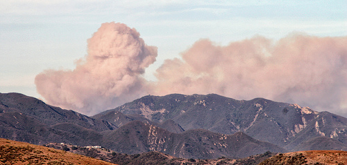
Well connected web denizen Doc Searls provides interesting commentary and some powerful photography to capture an off the tracks view of the Rancho Wildland Fire. A shout out to Doc for making these photos freely available, including the photo at the top of this article. His blog is here.

This is a Flickr badge which allows you to see the photos in a gallery or slideshow: Click on the "What is this?"

www.flickr.com
This is a Flickr badge showing public photos from Flickr tagged with Rancho Wildland Fire. Make your own badge here.

Another link to the Flicker photos..

Fire Update: As of this posting, InciWeb has an updated posting by the agencies working the fire.

Sunday, July 1, 10:00 p.m.

The fire had very little to no forward rate of spread today, except for some short uphill runs in the afternoon that were pushed by strong winds, and therefore accurate mapping of the fire's perimeter was possible. The result of today's mapping shows the fire to be a total of 482 acres and 60 percent contained. No date or time has been set for full containment.

Five hundred and ninety-nine individuals are currently assigned to the fire, which has been burning in light grass and some heavy brush. Some crews will continue to build handline to connect with dozer line on the western edge of the fire, as other crews continue to build handline on the eastern side of the fire.

The demobilization of some resources will be evaluated at 6:00 a.m. tomorrow morning, for the possible release of some engines that have been in place for structure protection.

No structures have been damaged or destroyed, and no injuries have been reported.

A Red Flag Alert for heightened fire danger has been extended for the area until Monday at 8:00 am.

Central Coast Type II Team Number 7, led by Incident Commander Jim Smith, took over management of the fire at 6:00 p.m. this evening.

Anonymous tip hotline: Citizens can submit anonymous tips regarding wildfire starts to sbsheriff.org. Tips can also be submitted by phone to the Santa Barbara County Sheriff's Detective Bureau at 805-681-4150.

Story photo by Doc Searls

Story Help (Click-ability)
Double-clicking on any word or phrase in this story will open a reference window with definitions and links to other reference material.

Comments

Discussion Guidelines

Thanks for the shout-out.

One fly in the collective ointment right now is the slowness of the InciWeb server, which is hosed much of the time. I checked with the guy running it, and he tells me they have more than a million hits a day. I'm looking into ways that tech-savvy citizens might help. If I get somewhere I'll let you know.

Oh, I also posted his piece...

http://doc.weblogs.com/2007/07/02#theFir...

... which includes a scary map from the Montecito Fire Department, showing the vast areas burned by earlier fires around here. The Rancho Fire could easily have been another Coyote Fire, which burned Mountain Road and the whole Santa Ynez ridge from there to past the Santa Ynez river. It's also clear that Santa Barbara will be visited by devastating fires periodically, for the duration.

dsearls (anonymous profile)
July 2, 2007 at 5:26 p.m. (Suggest removal)

Post a comment

Username:
Password: (Forgotten your password?)

Comment:

EVENT CALENDAR

Previous Month | Next Month

Today's Events Best Bets Submit an Event

Local Weather

Currently:
Clear Sky
Temperature:
63.0°
Wind:
14 WSW

Surf Report
  • Specials
  • InPrint
  • Top Emails
  • Wedding Guide 2009
  • SBIFF 2009
  • Local Heroes 2008
  • Best Of 2008
  • Tea Fire 2008
  • Blue Green Guide 2008
  • 2008 Election Coverage
  • Calendar of Fundraisers
  • Local Bands
  • Kid's Mother's Day Issue
  • Made in Santa Barbara
  • Summer Reading
  • Santa Barbara Reads 2009 Chooses Fahrenheit 451
  • East Beach Water Contamination Mystery Continues
  • El Corazón del Perro
  • The Stone Foxes Return to Rock’s Roots
  • Horseback Riding Helps Local Vets
  1. Cottage, Sansum May Fuse
  2. Pacific Capital Bancorp Refutes Takeover Gossip
  3. Santa Barbara Named One of “Ten Pricey Cities That Pay Off”
  4. Santa Barbara Scrapbooks to Close Its Doors
  5. Official Michael Jackson Party Announced
  6. Deceased Man Found in Car on Coast Village Road
  • CREATE AN ACCOUNT
  • LOG.IN
  • CONTENTS
  • CLASSIFIEDS
  • ARCHIVE
  • INFO | ADVERTISING | CONTACT US
Google
 
Independent.com Web
Copyright ©2009 Santa Barbara Independent, Inc. Reproduction of material from any Independent.com pages without written permission is strictly prohibited. If you believe an Independent.com user or any material appearing on Independent.com is copyrighted material used without proper permission, please click here.
This is our Privacy Policy.