Zaca Fire Rages in Backcountry
Fire Crews Battle Destruction, Unfavorable Odds
What started as an auspicious Independence Day did not end that way, at least not for several area ranch hands repairing a water pipe in the Santa Ynez Valley. Sparks from a metal grinder ignited nearby brush, and the flames spread before the crew could stomp them out. The location was Bell Canyon-not too far from Zaca Lake and about as unfortunate a location for a fire to start as one could find. The canyon is narrow, rising 1,500 feet to the western end of Zaca Ridge-almost completely inaccessible country. Add searing heat and bone-dry vegetation to this mix, and the conditions exist for a major blowup once the brush has been lit.
The county Fire Department was on the scene within minutes, but what was to become known as the Zaca Fire had already developed a head. The initial objective in fighting a wildland fire is to build containment lines on either side of the blaze. “When a fire is running,” explained Rich Phelps, a U.S. Forest Service spokesman, “you can’t attack it on its leading edge. Rather, you begin building a box around it, and if you can build containment lines fast enough, you can circle around and enclose the fire.”
Unfortunately, though fire crews were able to form containment lines on the bottom edge of the fire, they could not do so up the steep hillsides leading to Zaca Ridge without a lot more equipment. Strategies emerged. First, the California Department of Forestry & Fire Protection (CAL FIRE), Santa Barbara County Fire, and the Forest Service formed a “unified command” with incident commanders (ICs) from each of the agencies forming a decision-making team. While hand crews built the initial containment lines in the Bell Canyon area, the ICs initiated a long-range planning process that will lead to containment within a reasonably short period of time. “There isn’t just a Plan A,” Phelps said. There are plans B, C, and D-or more if conditions warrant.
For the latter part of Wednesday and Thursday, Plan A focused on holding the Zaca Ridge to the east and adding several miles of dozer lines west of Wildhorse Peak, down Schoolhouse Canyon to the Sisquoc River. If both of these lines held, the crews figured, the Santa Ynez Valley and country leading toward Santa Maria would be safe.
To reinforce Zaca Ridge, dozers were quickly moved up Figueroa Mountain Road to a rough high-clearance road known as the Catway that leads nine miles out to Wildhorse Peak. But by late Thursday, as dozers slowly churned up a wide swath of chaparral from Figueroa Mountain to a point several miles beyond Wildhorse, the fire closed on the ridge above Bell Canyon. It was time for Plan B.
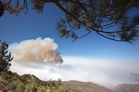
For the situation team, which analyzed evolving fire conditions, nerves frayed as it appeared almost certain the ridge would be breached. Early Friday morning, flames progressed slowly down the backside of the ridge. But as they reached the heavier north-side fuel, the burning intensified. Huge billowing clouds of smoke loomed like thunderheads, filling the sky. By 2 p.m., the entire area near Wildhorse Peak became one large mile-wide thunderhead with a superheated funnel of hot gases pushing smoke, cinder, and embers sky-high. Spot fires appeared sometimes a quarter- to half-mile ahead of the advancing thunderhead.
As the fire moved steadily eastward, fueled by thick chaparral that hadn’t burned in ages, commanders re-evaluated which lines they could hold and which needed to be shifted. Three places were deemed critical: the western edge near Schoolhouse Canyon, the Sisquoc River below Manzana Schoolhouse, and Zaca Ridge. Omitted from this list was the wilderness boundary along Manzana Creek. While it would have been desirable to keep the fire out of the wilderness, there was no way to establish a line along the Manzana that could have been held.
On Thursday and Friday, dozer crews were busy building a line they could hold along the Sisquoc to the National Forest boundary near Horse Canyon. As the fire continued down toward Manzana Schoolhouse on Friday, a strike team set out up the Sisquoc River to protect historic structures such as the schoolhouse and Dabney Cabin.
Saturday afternoon, Forest Service personnel led Hot Shots-firefighters trained to cut down brush at the blaze’s edge-as well as dozers and graders up the river and reached the schoolhouse area about 2 p.m. Across the river on Wells Mesa, a quarter-mile swath of the fields were scraped to mineral soil to create a safe zone for the Hot Shots. Nearby, flames dropped down Lion Canyon toward the Manzana. Dozers cleared brush around Dabney Cabin and the schoolhouse, and helicopters doused the structures with retardant. By 6 p.m., the dozer and grader operators retreated to the safety zone, hoping their work would save these treasures. When they returned the next day, they cheered when they found both still intact.
Plans were also developed to hold Zaca Ridge at all costs. The strategy was fairly simple: Dozers would widen the ridge even further while hand crews cut vegetation on the ridgetop to ground level, raking the soil so that nothing was left to burn. Then, as flames inched toward the ridgeline, helicopters dropped loads of water and retardant to dampen the fire as it reached the dozer lines. Meanwhile, air tankers blanketed the ridge on both sides east of the fire, coating it in anticipation of the fire continuing its eastward momentum. This pattern was repeated along the ridge all Sunday and Monday. The ridge held.
Late on Monday, total personnel increased to 1,756. The fire costs so far had reached a staggering $6.9 million. However slow the progress seems, thus far the fire suppression team has done a tremendous job despite terrible odds. “We’ve met our daily objectives every day,” public information officer Jim Arvizu said. “However, not all objectives lead to satisfying conclusions. Given the topography, heat, lack of access, and the drop-dead dry fuels, we’ve been able to do almost everything we wanted to do.”
Huge thunderheads of smoke hovered over Hurricane Deck Monday evening, the fire vaporizing almost everything in its path. The day after the fire crossed the Manzana and began up the hills behind the John Cody homestead, it had burned its way more than three miles up Bald Mountain Canyon and was now attacking the higher ridges of the Deck, the heart of the San Rafael Wilderness.
Though their efforts have been successful in almost all respects, there are some battles firefighters cannot win. Once the fire crested Zaca Ridge on Friday, it was almost inevitable the wilderness would burn. For some, this will be both a blessing and a tragedy; though the wilderness must burn, for it to happen in such a fashion is not good for the land or its inhabitants.
Temperatures cooled on Tuesday, due to monsoon-type conditions that also may bring intense weather fronts and dry lightning. The fire seemed to be stagnating, but it may be weeks before we know the fate of the San Rafael Wilderness. Those familiar with the land should know one thing, however: Despite the blackened, desolate landscapes, it will recover. It is, after all, wild country-and left to its own devices, it will heal itself.