
Forest Service Reopens Burn Areas
Trail Damage Extensive; Public Urged to Use Extreme Caution

Los Padres National Forest officials announced on March 31 that the area burned by the Zaca Fire, closed to public entry since the fire began in July 2007, will be reopened at noon, April 4. The trail system has sustained extensive damage and the public is urged to use extreme caution when traveling in the affected area, said Forest Supervisor Peggy Hernandez.
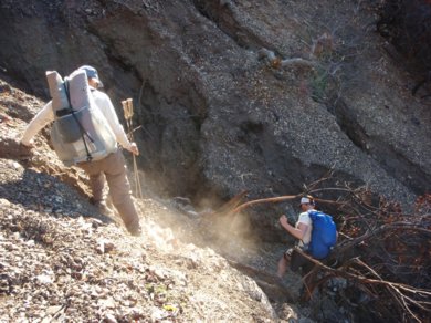
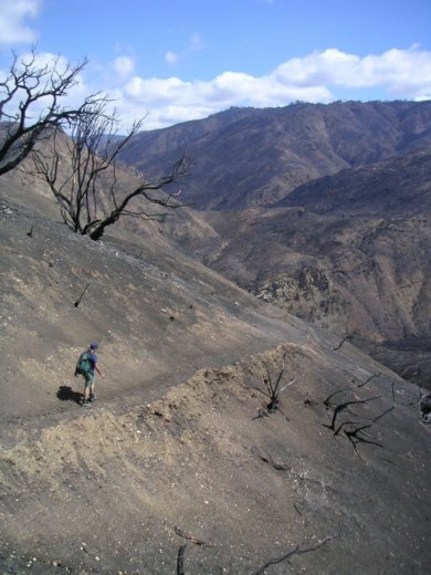
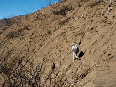
“A great deal of dry gravel erosion occurred immediately after the fire, and the winter rains and heavy snowfall caused additional damage,” explained Hernandez. “Particularly hard hit are vulnerable mid-slope trails like segments of the popular Santa Cruz trail, and the Grapevine and Potrero trails in the San Rafael Wilderness. Another key area that sustained significant damage is the Manzana Narrows. Many sections of the trail system have been completely obliterated.”
Forest Service backcountry manager Kerry Kellogg estimates that 167 miles of backcountry trail were impacted by the Zaca Fire. Kellogg said other safety hazards include deep gullies, landslides and rockslides on trails; burned trees and tree limbs that can fall without warning; burned stump holes; and damaged or missing trail signs. He warned that the land, particularly the steep terrain, will be changing constantly and will be unstable for many years until the vegetation becomes reestablished. “Even the most experienced hikers will need to stay alert to their surroundings and not take unnecessary risks,” Kellogg said.
Forest Service officials also warned that most of the burned area will not be safe for equestrians until the trails are repaired. “Hikers may be able to pick their way across some damaged areas, but stock would have a very difficult time,” said Kathleen Phelps, District Ranger for the Santa Lucia District which encompasses most of the San Rafael Wilderness. Of particular concern are sideslope trails where horses may not be able to turn around safely if they encounter a landslide or gully.
A small group of dedicated volunteers who work regularly with the Forest Service have been surveying the burned area to document trail conditions. While they have explored a large area, there are still some regions of the backcountry in the Dick Smith and San Rafael Wildernesses that no one has seen since the fire.
“We are still collecting information on trail conditions, and the trails we know about have changed over the past few months,” said Santa Barbara District Ranger Cindy Chojnacky. She said it will take years to repair the trail system. “We have started work with trail crews and volunteers in priority areas, and will extend that work as the ground stabilizes. However, some of the more remote, less traveled trails may never be reestablished.”
Ironically, some ridge and canyon trails in the burn area, previously impassable due to brush, may be open for the first time in years, Chojnacky said. “For instance, the Hurricane Deck trail is now visible, although it is hard to follow in mid-slope areas. The trails in Indian and Mono Creeks are not in great shape, but the canyons have silted in and the creek banks are fairly easy to hike.” For experienced hikers who want to explore, “probably the best advice is, check with the district on specific areas and don’t count on making a loop trip.”
Some of the burned area will still be subject to temporary closures during rainy periods. Some gates will remain closed to protect fuelbreaks, fire containment lines and open areas from vehicle trespass until vegetation is reestablished. For example, an eleven mile section of the Buckhorn Road will remain closed to vehicles starting from the point where it intersects the Camuesa Road. In addition, there are still several roads outside the burned area that sustained damage during the fire suppression efforts and are closed temporarily for repairs.
For more information about conditions in the Zaca Fire area, contact the Santa Barbara Ranger District Office on Paradise Road at (805) 967-3481, and the Santa Lucia District Office in Santa Maria at (805) 925-9538. Photos of some of the trail damage taken by the volunteer backcountry rangers are available on the forest website.
At the height of the Zaca Fire in August 2007, the closure encompassed over 660,000 acres between Highway 166 on the north and Highway 33 on the south. Nearly 330,000 acres have been closed to the public since October including most of the San Rafael Wilderness, all of the Dick Smith Wilderness.


