• CREATE AN ACCOUNT
  • LOG.IN
  • CONTENTS
  • CLASSIFIEDS
  • ARCHIVE
  • INFO | ADVERTISING | CONTACT US

  • Home
  • News
    • News Main Page
    • NewsFlash
  • A&E
    • A&E Main Page
    • Movie Times
    • TV Listings
    • A&E Blog
    • Art Galleries
    • Best Bets
  • Opinion
    • Opinion Main Page
    • Endorsements
    • Blogs
    • Columns
    • Voices
    • Letters
    • In Memoriam
    • Obituaries
  • Events
    • Today
    • Search
    • Submit
    • Best Bets
  • Living
    • Living Main Page
    • Outdoors
    • Travel
    • Sports
    • Peeps
  • Food & Drink
    • Food & Drink Main Page
    • All Restaurants
    • Delivery
    • All Bars & Clubs
    • Drink Specials
    • Open Now
  • Sports
  • Outdoors
    • Outdoors Main Page
    • Outside Insider
    • Spotlight On
    • Features
  • Classifieds
    • Real Estate
    • Jobs
    • Autos
  • Obits

    Lightning Strikes Spark Fires in the San Rafael Wilderness

    Wilderness Area Fires Burning in Rugged Terrain


    Originally published 6:26 p.m., August 15, 2008
    Updated 9:19 p.m., August 15, 2008
    By Ray Ford (Contact)
    Article Tools
    Print friendly
    E-mail story
    Tip Us Off
    iPod friendly
    Comments
    Bookmark This
    del.icio.us. del.icio.us.
    Digg! Digg!
    furl furl
    google google
    newsvine newsvine
    reddit reddit
    technorati technorati
    Facebook Facebook
    Yahoo! My Web 2.0 Yahoo!

    Those lightning strikes last night that appeared to be benign this morning have ignited five new fires in the Santa Barbara backcountry.

    Google Map of the fire area with points added by Ray Ford.
    Click to enlarge photo

    Google Maps

    Google Map of the fire area with points added by Ray Ford.

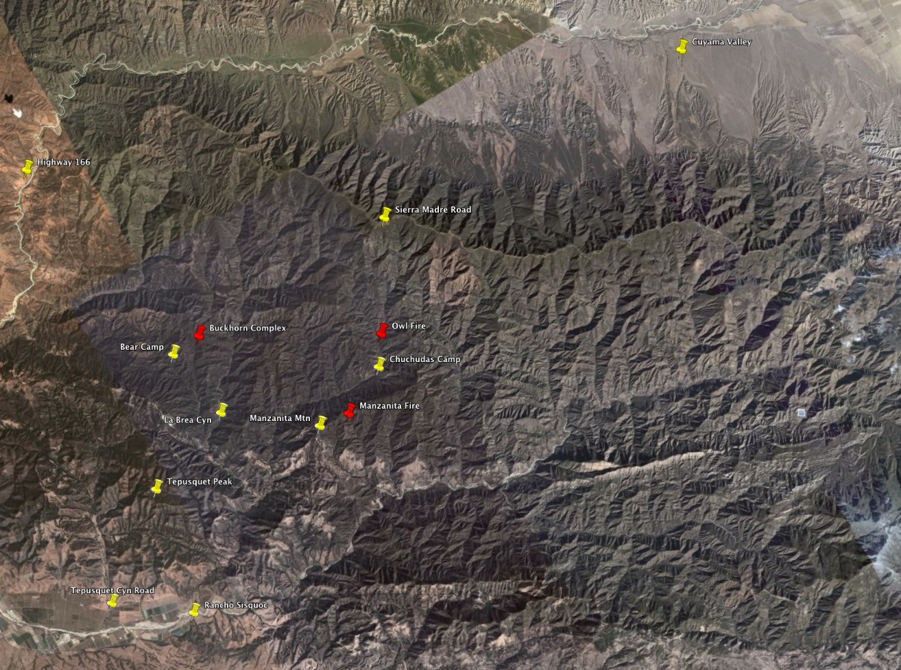
    The fires are burning in or near the San Rafael Wilderness in northern Santa Barbara County approximately 18 miles east of Santa Maria. For those who frequent the Foxen Canyon wine country, the blazes are several air miles north of historic Rancho Sisquoc and four miles east of homes along Tepusquet Canyon.

    The Buckhorn Complex consists of three lightning fires located approximately one mile northeast of Bear Campground and three miles east of Tepusquet Canyon Road. As of noon today, the three fires had burned a total of about 60 acres and by this evening had grown in size to from 125 to 160 acres. The fire is burning in heavy chaparral, in rugged terrain, and is moving primarily northward up Bear Canyon. Currently the fire doesn’t pose a threat to any structures.

    The Owl Fire has now burned 15-20 acres in the Salsipuedes Canyon area, approximately two miles to the north of Chuchudas Campground in the San Rafael Wilderness. It is burning in heavy fuels in steep, inaccessible country

    The Manzanita Fire is now 20-30 acres in size and is located approximately one mile east of Manzanita Mountain. This is outside the San Rafael Wilderness and is also burning in heavy fuels in country that is difficult to access.

    Ray Ford

    Biker Paul Cronshaw looks out on the area where lightning strikes have ignited five fires. Only a few narrow dirt roads provide access to points near the fire lines.

    Forest Service Public Information Officer Joe Pasinato explained that the lack of access due to remote locations is a significant challenge with each of the fires. However, air resources were on scene within the hour and by 5 p.m. the seven air tankers had dropped enough retardant to circle each of the fires. An additional air tanker is on order. Four helicopters were also being used to begin ferrying in hotshot crews to each of the fire sites.

    “We know the retardant won’t stop the fires from spreading eventually,” Los Padres Forest Public Affairs Officer Kathy Good added, “but hopefully it provides the crews with enough time to build hand lines around each of the fires.” Currently, 80 firefighters are on the fire lines and 170 additional firefighters are on order. This includes a smoke jumping crew from Redding that should be deployed before dark tonight. The crews plan on working through the night.

    “Fortunately it appears we won’t have a repeat of last night’s lightning strikes,” Good said, “and the forecast is for a marine layer to begin moving in tonight which will be really helpful.”

    Due to the fire emergency, public entry is now prohibited on national forest lands in the general vicinity of these fires, including the La Brea Canyon, Tepusquet Canyon, Colson Canyon, Rattlesnake Canyon and Buckhorn Ridge areas. The closure order is being finalized tonight. “This will impact deer hunting season quite a bit,” Good stated. “This is a popular area for hunting.” A map showing the exact boundaries of the closure should be available in early morning.

    While the Fire Information Call Center is currently not open, Good expects to have it in operation no later than 8 a.m. tomorrow. As new information becomes available, the Forest Service will update the recorded message through the night at (805) 961-5770 and switch to having the lines open for questions as soon as possible tomorrow morning.

    A Type 2 Incident Command Team under the direction of Jim Smith is also on order to oversee fire operations and should be in place tomorrow morning. A site for the command post has not been decided.

    Following is a verbatim update on the Los Padres National Forest fires, issued at 9 p.m.:

    Los Padres National Forest

    Santa Lucia Ranger District

    Lightning Fire Update

    August 15, 2008 --- 9:00 pm

    There are currently five lightning-caused fires burning in or near the San Rafael Wilderness in the northern Santa Barbara County portion of Los Padres National Forest. The fires are approximately 18 miles east of Santa Maria, CA.

    The Buckhorn Complex consists of 3 lightning fires located approximately one mile northeast of Bear Campground and 3 miles east of Tepusquet Canyon Road. As of 9:00 pm tonight, the three fires have burned a total of approximately 150 to 170 acres. The fires are burning in heavy chaparral, in rugged terrain and are currently moving in a northeast direction. The fires do not currently pose a threat to any structures. The nearest structures are about 4 miles to the west.

    The Owl Fire has now burned 20 acres in the Salsipuedes Canyon area, approximately 2 miles to the north of Chuchudas Campground in the San Rafael Wilderness. It is burning in heavy fuels. Crews will remain on the fire overnight. No structures are threatened.

    The Manzanita Fire is still 75 acres in size and is located approximately 1 mile east of Manzanita Mountain, is outside of the San Rafael Wilderness and is burning in heavy fuels. Earlier today, U.S. Forest Service Smokejumpers parachuted into the area of the fire and were successful in constructing a helispot, so that additional crews can be flown in via helicopter tomorrow. No structures are threatened.

    Lack of access is a significant challenge with all of the fires due to their remote location. No evacuations have been ordered and there have been no injuries reported.

    Firefighting resources today:

    7 AirTankers

    5 Helicopters

    80 firefighters + 170 ordered

    Due to the fire emergency, public entry is now prohibited on national forest lands in the general vicinity of these fires, including the La Brea Canyon, Tepusquet Canyon, Colson Canyon, Rattlesnake Canyon and Buckhorn Ridge areas.

    The Fire information Call Center is currently closed. New information will be available Saturday morning at 8:00 am, at 805-961-5770.

    Related Links

    • Lightning Ignites Blazes in Los Padres Forest
    Story Help (Click-ability)
    Double-clicking on any word or phrase in this story will open a reference window with definitions and links to other reference material.

    Comments

    Discussion Guidelines

    thanks for the up to the minute reports Ray. I don't know what we would do for news without the Independent!

    Readers say: Thumbs Up: 0 of 0 • Thumbs Down: 0 of 0

    briny (anonymous profile)
    August 15, 2008 at 8:54 p.m. (Suggest removal)

    I thought we had come a long way since the Smoky Bear "only you can prevent forest fires" days. I thought that the Forest Service now recognized that fire is a natural and necessary part of our local environment. I thought we all understood the folly of trying to suppress fires, for every given bit of brush will eventually burn, but by delaying that burn, we only get larger, hotter fires.

    And yet, the decades-old (century-old?) policy of putting out every fire, no matter where it is or what it threatens, continues. We put out the Gap Fire, sure, but we also put out a lightning-caused fire in an area so remote that there aren't even roads to it. Why?

    And not only do we send in hand crews, but we send in expensive air tankers that, admittedly, won't put the fire out, but will only "slow it down." The effectiveness of slowing a fire down can be seen in the case of the Zaca fire: it does nothing, zilch, nada. The Zaca fire roared on day after day despite being "cooled" and "slowed", and the one and only thing that eventually put it out were large backfires. I'm guessing that if the Forest Service had been willing to light large backfires from the start, the fire would have been out much sooner.

    The Los Angeles Times recently had a series on the cost of fire suppression. They reported how air tankers are in some cases useful, but in many if not most cases are nothing more than expensive spectacle, running up tabs of millions of dollars.

    Periodically I hear talk of changing our approach to fire suppression, but I see no actual evidence of any change.

    Readers say: Thumbs Up: 0 of 0 • Thumbs Down: 0 of 0

    gjanee (anonymous profile)
    August 15, 2008 at 9:49 p.m. (Suggest removal)

    Rainbow in a cloud without rain,
    Rainbow moving in the sky,
    Dry lightning strikes the dry land.

    Fires continue to run...

    Readers say: Thumbs Up: 0 of 0 • Thumbs Down: 0 of 0

    GoletaResident (anonymous profile)
    August 15, 2008 at 11:19 p.m. (Suggest removal)

    Post a comment

    Username:
    Password: (Forgotten your password?)

    Comment:

    EVENT CALENDAR

    Previous Month | Next Month

    Today's Events Best Bets Submit an Event

    Local Weather

    Currently:
    Clear Sky
    Temperature:
    50.0°
    Wind:
    5 NE

    Surf Report
    • Specials
    • InPrint
    • Top Emails
    • Best Of 2009
    • 2009 Election Coverage
    • Wedding Guide 2009
    • Blue Green Guide 2009
    • SBIFF 2009
    • Tea Fire 2008
    • Local Heroes 2008
    • Calendar of Fundraisers
    • Local Bands
    • The Independent’s Local Heroes
    • Viggo Hits The Road
    • Elings Park Expansion Shot Down
    • Doggie See, Doggie Do
    • Alison Saar at Atkinson Gallery
    • Sampling My Syrah, Sharing Your Chardonnay
    1. Eating Animals
    2. Producer Must Pay Landscaper
    3. High Noon in the Garden of Controversy
    4. Teacher in Trouble
    5. My Swine Flu Experience
    6. Bella Dolce Bakery Is Born
    • CREATE AN ACCOUNT
    • LOG.IN
    • CONTENTS
    • CLASSIFIEDS
    • ARCHIVE
    • INFO | ADVERTISING | CONTACT US
    Google
     
    Independent.com Web
    Copyright ©2009 Santa Barbara Independent, Inc. Reproduction of material from any Independent.com pages without written permission is strictly prohibited. If you believe an Independent.com user or any material appearing on Independent.com is copyrighted material used without proper permission, please click here.
    This is our Privacy Policy.