Feds Pull Funding for Key Channel Data Stations
Buoys Can't Stay Afloat
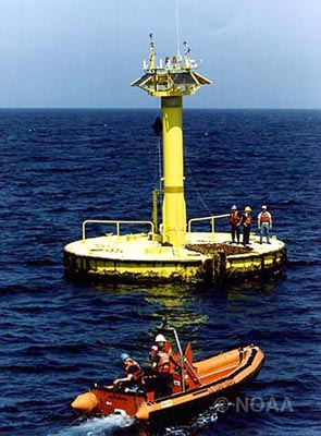
The waters of the Santa Barbara Channel are a majestic, mysterious, and often dangerous place to work and play. Luckily, for the boaters, surfers, divers, and fishers who find themselves on the frontlines of this open water landscape, a patchwork of data buoys bob at strategic points throughout the channel and the waters north. They stream real-time data about ocean, wind, and weather conditions to prevent any nasty surprises from catching mariners off-guard. However, if a recent funding decision by the federal government’s National Oceanic and Atmospheric Administration (NOAA) stands, two of these valuable stations-specifically the West Santa Barbara Channel buoy and the Pt. Arguello buoy-will be decommissioned in coming months and removed by the end of the summer, leaving a potentially treacherous information hole at the northwestern gate of the Channel.
In an average year, 7,000 vessels weighing 300 tons or more traverse the Santa Barbara Channel, as well as countless smaller vessels. All of them-whether they be merchant maritimers, wave-hunting surfers, oil barges, urchin divers, or yacht-driving pleasure cruisers-must keep one eye out for the ever-changing weather conditions of the channel. Known the world over for being able to switch from calm to chaotic in mere minutes, the Santa Barbara Channel is “a tricky place to forecast,” said Mark Jackson, the NOAA National Weather Service’s Southern California honcho. He lamented the likely loss of the offshore buoys, instruments that he said play a fundamental role in his agency’s forecasting and issuing of marine advisories and warnings. “When the north winds pick up, you can get some real strange and nasty effects real fast at the start of the islands,” he said. “The more tools we have to monitor this, the better.”
And with the geography of the islands and the South Coast working essentially as a massive funnel, all of these ill developments have very serious implications for boaters who find themselves “downstream.” Known simply as Buoy 23 (17 nautical miles northwest of Pt. Arguello) and Buoy 54 (38 nautical miles west of Santa Barbara), the two stations slated for shutdown are located at the aforementioned “start of the islands,” thus providing a critical stream of information via radio and Internet that ocean-goers can use to predict disaster even when they’re several miles from safety. Summing up the significance of NOAA’s decision, Santa Barbara Harbor operations director Mick Kronman was distraught, saying “This is very disconcerting for the boating public. Information from those buoys is crucial to recreational and commercial boater safety alike.” In slightly saltier terms, one longtime fisher put it this way during an anonymous phone call this week: “It’s simple, man. Lose those buoys and there’s a good chance somebody will die eventually,” he said.
The current situation is almost identical to one that occurred in 2005, when the approximately $60,000-per-year that keeps these buoys afloat dried up. At that time, the seafaring data collectors were supported financially by the Minerals Management Service (MMS) as part of a longterm research project with San Diego’s Scripps Institute. When MMS decided to pull the plug, NOAA stepped in and wrote a $160,000 check meant to bankroll the buoys for two more years. With that kickdown now all but gone, Jackson explained the current plan: “The buoys will be disestablished and removed early this fall. However, if anything happens to them between now and then-like they break down or malfunction-they won’t be fixed.” Hoping to stop the action and solicit another last-minute save, Kronman said that both the National Weather Service and the Channel Islands National Marine Sanctuary have begun a letter-writing campaign to their supervisors, as has the City of Santa Barbara. Calls to the National Data Buoy Center in Mississippi, the headquarters for NOAA buoy operations, were not returned.
The Arguello and West Santa Barbara channel devices are just two of nine total buoys in and around the channel, in addition to several other data recording devices in both near- and off-shore waters. With this in mind, Jackson said that another possible solution, though “certainly less than ideal,” would involve relocating one or two of the remaining buoy stations, likely the Pt. Conception buoy, closer to the West Santa Barbara Channel location.