• CREATE AN ACCOUNT
  • LOG.IN
  • CONTENTS
  • CLASSIFIEDS
  • ARCHIVE
  • INFO | ADVERTISING | CONTACT US

  • Home
  • News
    • News Main Page
    • NewsFlash
  • A&E
    • A&E Main Page
    • Movie Times
    • TV Listings
    • A&E Blog
    • Art Galleries
    • Best Bets
  • Opinion
    • Opinion Main Page
    • Endorsements
    • Blogs
    • Columns
    • Voices
    • Letters
    • In Memoriam
    • Obituaries
  • Events
    • Today
    • Search
    • Submit
    • Best Bets
  • Living
    • Living Main Page
    • Outdoors
    • Travel
    • Sports
    • Peeps
  • Food & Drink
    • Food & Drink Main Page
    • All Restaurants
    • Delivery
    • All Bars & Clubs
    • Drink Specials
    • Open Now
  • Sports
  • Outdoors
    • Outdoors Main Page
    • Outside Insider
    • Spotlight On
    • Features
  • Classifieds
    • Real Estate
    • Jobs
    • Autos
  • Obits

    Ray Ford

    Tunnel Connector Trail has no vegetation left along it at all and this fork of Rattlesnake Canyon is completely burned to mineral soil.


    County Flood Officials Begin Post-Fire Preparations

    The Good News is That There is Plenty of Time to Get Ready


    Thursday, May 14, 2009
    By Ray Ford (Contact)
    Article Tools
    Print friendly
    E-mail story
    Tip Us Off
    iPod friendly
    Comments
    Bookmark This
    del.icio.us. del.icio.us.
    Digg! Digg!
    furl furl
    google google
    newsvine newsvine
    reddit reddit
    technorati technorati
    Facebook Facebook
    Yahoo! My Web 2.0 Yahoo!

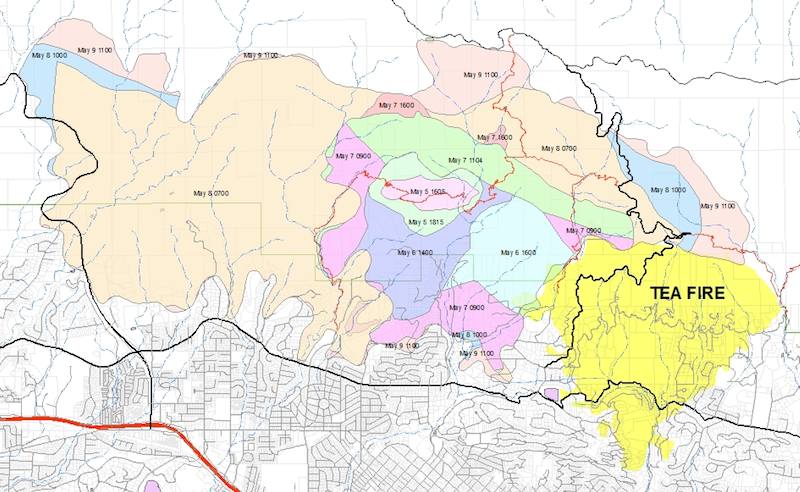
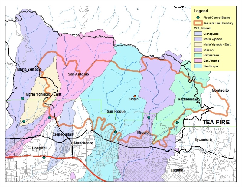
    Wednesday morning I sat down with Tom Fayram, deputy director of Santa Barbara County's Public Works Department to get an assessment of the impacts of the Jesusita Fire on the watersheds immediately above Santa Barbara. When I arrived Fayram was already studying a huge map of the burn area with each of the canyons highlighted in color. On top of the watershed boundaries was a thick red outline of the fire’s boundary.

    Progression map of the Jesusita Fire from beginning through May 12.
    Click to enlarge photo

    GIS Map by Ray Ford

    Progression map of the Jesusita Fire from beginning through May 12.

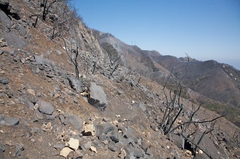
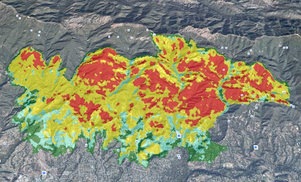
    The problem became apparent immediately. “The San Roque, Mission and Rattlesnake areas got hit hard,” Fayram says. “We’re just now getting the burn intensity information and it doesn’t look good. All three canyon areas have sustained a large percentage of vegetation loss in the upper areas.”

    Burn intensity map overlaid on a Google Earth map shows the intensity of the burn. Red indicates the highest intensity burn areas.
    Click to enlarge photo

    USFS Satellite Data

    Burn intensity map overlaid on a Google Earth map shows the intensity of the burn. Red indicates the highest intensity burn areas.

    Fayram adds, “There are a lot of parallels to the Gap Fire in the Goleta area.” He ticks a series of points off on his fingers “The acreage burned and the amount of vegetation burned is almost the same. There are multiple canyons involved too and the topography is extremely steep. We may use many of the same techniques for mitigating the damage here as we did on the Gap Fire.”

    These techniques include opening up flood control basins, brush clearance along the riparian areas and the use of debris racks. Fayram also mentions the use of hydro mulch as well in some areas, though he acknowledges there were problems with the quality of the material used on the Gap Fire.

    Watershed areas with the fire perimeter overlaid on them show the areas in each canyon most impacted by the burn. Note locations of flood control basins in each canyon.
    Click to enlarge photo

    Flood data courtesy of SB County Flood.

    Watershed areas with the fire perimeter overlaid on them show the areas in each canyon most impacted by the burn. Note locations of flood control basins in each canyon.

    But I point out there is one big difference in that the urban interface is much closer to the burn area and there isn’t much of a buffer between the potential mudslide and flood areas and the homes. “In that respect, the Jesusita Fire was much more like the Tea Fire,” Fayram responds. “In Goleta we had a mile or more of buffer with the orchards but in the upper parts of these canyons there are houses immediately below the burn area. That’s a challenge.”

    The good news, Fayram points out is that it is only mid-May and we’ve got six months to prepare before winter rains are upon us.

    Look for community meetings sponsored by the local agencies in the next few months to answer homeowner questions and help the community prepare.

    Story Help (Click-ability)
    Double-clicking on any word or phrase in this story will open a reference window with definitions and links to other reference material.

    Comments

    Discussion Guidelines

    Post a comment

    Username:
    Password: (Forgotten your password?)

    Comment:

    EVENT CALENDAR

    Previous Month | Next Month

    Today's Events Best Bets Submit an Event

    Local Weather

    Currently:
    Clear Sky
    Temperature:
    63.0°
    Wind:
    13 W

    Surf Report
    • Specials
    • InPrint
    • Top Emails
    • Best Of 2009
    • 2009 Election Coverage
    • Wedding Guide 2009
    • Blue Green Guide 2009
    • SBIFF 2009
    • Tea Fire 2008
    • Local Heroes 2008
    • Calendar of Fundraisers
    • Local Bands
    • Within the Syuxtun Story Circle
    • Camellia Sasanqua
    • Whole New Ballgame
    • Gratuitous Gore on Highway 154
    • Saul Williams Brings Afro-Punk Tour to Velvet Jones
    • Where There’s a Dill, There’s a Way
    1. Travis Armstrong Is Outta There
    2. S.B. Bank & Trust's Rocky Year
    3. UC Campuses Dominate Rankings
    4. What buildings did architect Julia Morgan design in Santa Barbara?
    5. Sexile
    6. Rattlesnake and San Roque Side of Jesusita Trails to Re-Open Friday
    • CREATE AN ACCOUNT
    • LOG.IN
    • CONTENTS
    • CLASSIFIEDS
    • ARCHIVE
    • INFO | ADVERTISING | CONTACT US
    Google
     
    Independent.com Web
    Copyright ©2009 Santa Barbara Independent, Inc. Reproduction of material from any Independent.com pages without written permission is strictly prohibited. If you believe an Independent.com user or any material appearing on Independent.com is copyrighted material used without proper permission, please click here.
    This is our Privacy Policy.