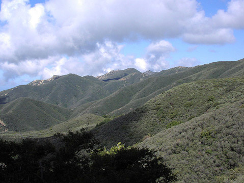
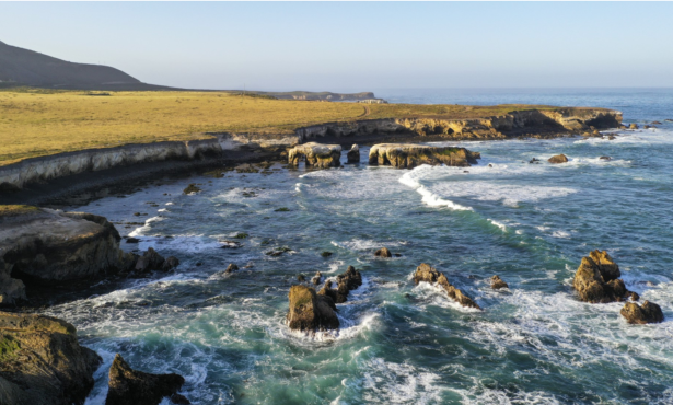
The Santa Ynez Mountains rise majestically above Santa Barbara’s South Coast, forming a scenic evergreen backdrop that enhances the stunning beauty and quality of life in our communities. These rich, green, chaparral-covered hills perched above the vast blue Pacific Ocean create a postcard-like setting that gives Santa Barbara its Mediterranean feel.
Unfortunately, the deep-rooted chaparral woodlands that literally hold our mountainsides together during rainstorms are being clear-cut at an alarming and increasing rate, without regard for their beauty or ecological values. Hundreds of acres have been felled and more land is being clear-cut each day. Many of these clearings are in remote, natural areas not located near homes or populated areas. Tragically, the County currently has no effective policies or ordinances to protect the hillsides, wildlife habitats, and people living downhill from steep, clear-cut mountainsides.
Importance of Chaparral: Chaparral is a beneficial native plant community in Santa Barbara County as well as globally. Chaparral occurs only in some Mediterranean climates and only on a small percent of the Earth’s surface. It is one of the rarest habitats on Earth.
Local chaparral forests harbor many unique species. Some, like the Santa Ynez Walking Stick, are found nowhere else in the world. Our chaparral community harbors at least 40 special-status species including: the side-blotched lizard, the late-flowered mariposa lily, the silvery legless lizard, the American badger, the coast patch-nosed snake, the Santa Barbara honeysuckle, the California newt, and the elusive ringtail.
Chaparral also supports hundreds of plant species which control erosion and protect people from landslides and flooding. When rain falls the chaparral plants capture the raindrops and allow them to trickle into the soil, recharging our groundwater basins.
Species that live in our creeks, including the endangered steelhead, also benefit from chaparral. Creeks would be filled with mud and debris without these woodlands that protect against erosion and sedimentation. Stream flows would dwindle without the rain-capturing chaparral, and fish, frogs, turtles, and other creatures would quickly disappear.
In addition, chaparral can actually help reduce fire hazards. As chaparral is removed, more ignitable non-native annual weeds such as thistle can invade, exacerbating rather than reducing fire hazards. This is already occurring in Santa Barbara County and throughout southern California. Maintaining a healthy chaparral forest is an important step towards preventing the ignition of fires.
Protecting Chaparral Habitats: Despite the many benefits that chaparral provides, Santa Barbara County regulations offer little protection. In fact, the county’s Brushing Ordinance allows unlimited chaparral clear-cuts and does not trigger any environmental protection measures. An update to this 30-year old ordinance is long overdue. Like other county ordinances, the Brushing Ordinance needs a public process for addressing ecological concerns. Any serious impacts – like increased flooding and loss of habitat for endangered wildlife - should be avoided or minimized. Unfortunately, sensitive chaparral habitats are being removed with no public notification, no county review, and no concern for the rare plants and animals that call chaparral home.
Fire Safety in Chaparral Areas: Chaparral should be cleared to create defensible space around homes for wildfire protection. This protects people and homes from fires and can halt the spread of a house fire. When directed by the Fire Department, clearing for fire protection is appropriately exempt from the Brushing Ordinance.
In order to maximize fire safety in mountain neighborhoods and the wildland-urban interface, we believe that:
• Defensible space should be created and maintained around all homes and access roads.
• Homes should be actively fire-proofed through replacement of wood shingles with tiles, and other measures;
• New homes should not be constructed in high fire-hazard areas because they put lives at risk, burden our overtaxed fire response system, and can be sources of wildfire ignition; and
• Orchards should be encouraged, planted, and maintained in foothill locations as fuel breaks between chaparral habitats and residential neighborhoods.
Financial resources for fire safety are limited and should be used to promote defensible space and to fireproof homes instead of to clear-cut remote wildland chaparral habitats. Focusing clearing around homes and roads will protect our community from wildfire, will avoid erosion and flooding, and will protect our watersheds and wildlife habitats.
Lessons Learned from the Chaparral Forest: Chaparral habitats are ecologically fragile. The many plant species help prevent erosion, landslides, and flooding, enhance groundwater recharge, provide homes for dozens of rare animals, and form our communities’ gorgeous scenic backdrops. Clearing chaparral for fire safety can be a necessary and important tool for community fire preparedness, and clearings directed by the Fire Department are properly exempted from county rules and regulations. Poorly planned and unnecessary chaparral clearing projects, however, damage local watersheds and ecosystems and increase risks to our communities.
The county should update its planning tools so that fire safety measures protect the public’s right to healthy watersheds. This would balance important community interests including fire safety and better protection for the many birds and wildlife species that reside in our beautiful but threatened chaparral woodlands.
Brian Trautwein is an environmental analyst with the Environmental Defense Center. Eddie Harris is president of the Santa Barbara Urban Creeks Council and a retired Santa Barbara County firefighter.


Previous Month


Comments
Nice article. Can you please be more thorough and include the exact locations where "Hundreds of acres have been felled and more land is being clear-cut each day." I would personally like to go and see this for myself. Thanks!
surfrmom (anonymous profile)
July 6, 2011 at 9:53 a.m. (Suggest removal)
@surfmom
Check out the ridge just north of Painted Cave on the north side of Camino Cielo and west of Knapp's Castle and the Snyder trailhead. That area used to be all chaparral but was totally wiped out by giant Masticator machines maybe 2 summers ago. Its all turning to weeds now so the idea of creating a firebreak seems to have backfired.
Also check out the ridge on the north side of E. Camino Cielo near the intersection with Gibraltar Rd. I saw the Masticators working there a few years ago too.
EastBeach (anonymous profile)
July 6, 2011 at 7:44 p.m. (Suggest removal)
Here is an article (with photos) about the clear cutting near Painted Cave:
http://www.californiachaparral.com/cp...
tabatha (anonymous profile)
July 7, 2011 at 4:51 p.m. (Suggest removal)
Thank you BT and Eddie for bringing this issue to our attention. Part of the incredible beauty of Santa Barbara is the chaparral, the beach and the ocean. All of our various environments contribute to the diversity of wildlife and the general value of living here and anything that diminishes one part of that threatens the whole.
We should all take the time to send e-mails, letters or phone calls to our Supervisors to ask them to address this issue before it is to late.
Noletaman (anonymous profile)
July 8, 2011 at 11:33 a.m. (Suggest removal)
"Its all turning to weeds now so the idea of creating a firebreak seems to have backfired."
Not at all, now I cannot speak for that location as I have not seen it, but, a fireline can be cut much faster through "weeds" than through a brushfield.
Much of our chaparral lands were once grassland. The Chaparral has come in due to fire suppression. If we could return to a natural fire regime, the areas that are now chapparal would be greatly reduced in size.
"Chaparral should be cleared to create defensible space around homes for wildfire protection. " Just what is defensible space, having seen 200 foot flame heights, and fires jumping 8 lane freeways, it seems that defensible space is open to some interpretation.
Toiyabe (anonymous profile)
July 11, 2011 at 1:49 p.m. (Suggest removal)
Toiyabe has perpetuated a common misconception about chaparral; "The chaparral has come in due to fire suppression."
http://www.werc.usgs.gov/OLDsitedata/...
In their conclusion Moritz, et. al (Front Ecol Environ 2004; 2(2): 67–72) say:
"Our results contradict the widely held belief that large wildfires in California shrublands are the direct result of unnatural fuel accumulation due to fire suppression."
and
"Although prescription burning and other fuel manipulations
should still be useful at strategic locations along the urban–wildland interface, we may need to accept large fires as natural and inevitable events on many shrubland landscapes. .. [snip] ... this study has relevance for many fire-prone regions that are routinely exposed to extreme fire weather. Minimizing losses of life and property will ultimately require a science-based approach that integrates fireproofing of structures, intelligent landscaping, better evacuation preparation, and land use planning that constrains rapidly expanding urban–wildland interfaces."
binky (anonymous profile)
July 11, 2011 at 3:19 p.m. (Suggest removal)
"As one of only five areas with a Mediterranean-type climate in the world -- all of which are on the hotspot list -- the California Floristic Province is characterized by hot, dry summers and cool, wet winters. The region contains a wide variety of ecosystems, including sagebrush steppe, prickly pear shrubland, coastal sage scrub, chaparral, juniper-pine woodland, upper montane-subalpine forest, alpine forest, riparian forest, cypress forests, mixed evergreen forests, Douglas fir forests, sequoia forests, redwood forests, coastal dunes, and salt marshes. "
"Similar plant communities [to chaparral] are found in the four other Mediterranean climate regions around the world, including the Mediterranean Basin (where it is known as maquis), central Chile (where it is called matorral), South African Cape Region (known there as fynbos), and in Western and Southern Australia."
That is, chaparral is a type of vegetation that has adapted to a Mediterranean-type climate, similar types of which are found in only 5 places in the world. The fact that there has been simultaneous evolution speaks highly to the fact that chaparral has been around for a very long time and is highly adapted (evolved) to the conditions in which it grows.
To state that there was once grassland instead of chaparral is
simply incredible. It also indicates a complete lack of understanding why grasslands occur in certain areas, and why chaparral is found in others.
Unfortunately, more than 99% of the grass growing in the grasslands of CA today is non-native.
Sources:
http://en.wikipedia.org/wiki/Chaparral
http://www.biodiversityhotspots.org/x...
tabatha (anonymous profile)
July 11, 2011 at 8:12 p.m. (Suggest removal)
And now we are blessed with mexican nationals polluting the heck out of our backcountry by growing pot in it.
Riceman (anonymous profile)
July 20, 2011 at 6:01 p.m. (Suggest removal)
I thought this was front country:
"The locations included three grows in the San Antonio Creek area, which yielded 9,652 plants and two additional separate grows above Montecito in the Romero Canyon area, which yielded 8,726 plants."
Also, if there was not a market, there would be no growing. As one Edhat poster pointed out "The problem is us."
tabatha (anonymous profile)
July 20, 2011 at 8:16 p.m. (Suggest removal)
Brian has been tilting at this particular windmill quite vigorously at Planning Advisory Committee meetings, and, I have to admit, his alarmist presentation does raise some concerns which we would be fools to ignore. Despite EDC's Quixotic crusade regarding Tranquillon Ridge fiasco and their jihad at Goleta Beach, I must reluctantly conclude that they may, in this instance, be onto something. Perhaps.
Correct me if I'm wrong, but assuming that the gloss on this matter which Brian presents at http://www.californiachaparral.com/cp... is not a Chicken Little scenario ala the DCPP scare stories we have been hearing of late,
and therefore it is incumbent upon all of us high spirited "bright green" visionaries to lay seige to the castle in order to make peace in the valley, the following question is unanswered:
Why does the article ask us to email Janet Wolf when it is Joni Gray and Steve Lavagnino who probably most need convincing on this issue?
This is, if we follow the EDC leadership, we would be proposing a classic case of the State Interest abrogating the presumptive right of property owners.
If the state interest is sufficiently urgent to trump the presumptive private property rights which must perhaps be subrogated, it would be the more conservative, not the most liberal Supervisors who might object to any legislative remedies.
Emails to Janet Wolf are not going to accomplish much, she is already in the ecologically-aware camp of those who are quite demonstratively concerned about the environment, and she gets Earth Democracy Buuut - I don't think that Steve or Ms. Gray would hesitate to enact an ordinance if they thought that a laissez-faire neglect of this issue might put at risk our vineyards, cattle ranches and wild land residences which might be subjected to under-insured losses if the chapparal depletion did result in yet another traumatic forest fire in our county.
But don't forget that to some extent, our addiction to the Concrete Jungle has occluded us from recognition that to some degree natural burns are part of nature's cycle, and if we don't create a focused response to the legitimate concerns of private property owners we will just be regarded as a http://www.appropedia.org/Clown_Army
Geof_Bard (anonymous profile)
July 22, 2011 at 1:58 p.m. (Suggest removal)
So it seems this is taking place on some immediate ridge lines right behind SB... I would like to hear via the Forest Service fire fighting perspective on how effective this "mastification" is. It must be much easier to control "weeds" than chaparral especially when clearer spaces are needed for dumping fire retardant (hopefully that mixture gets better) when fighting fires. Personally I'm not too upset about it here because this area doesn't fit my idea of "remote" and is much more of a wide urban/wildland interface. Certainly not wilderness. Maybe it just comes down to different interpretations of what type of fire suppression to engage in. I hear all of the chaparral arguments, but in this case and with how terribly fast we've seen fires move in the past, this is one issue I can live with. The much bigger watersheds in the real backcountry wilderness are thankfully immune from this type of clearing. Sometimes we just need the sacrificial lamb... live with it.
surfrmom (anonymous profile)
July 22, 2011 at 7:10 p.m. (Suggest removal)
How effective was the Windy Gap scar at stopping fires from jumping? Not at all.
In high wind with lots of embers, what has been cleared now will be ineffective at stopping fire from spreading. Instead what has been cleared, will be the beginning of the degradation of the whole area as noxious weeds such as Star Thistle take hold.
I am not knowledgeable about watersheds in this area - so this is just guesswork on my part. The San Marcos Pass area receives far more rainfall than the back country wilderness. In an area often plagued by drought, we should maximize sources of water and look after what we have.
A better response is to make homes withstand fire, as one home did in the Tea Fire. Otherwise, it is just wasteful "imperialism" of wilderness areas from which, if left untouched, we all benefit and for the most part do not understand or appreciate.
tabatha (anonymous profile)
July 23, 2011 at 1:47 p.m. (Suggest removal)