
Scaling Grass Mountain
Santa Ynez Hike a Worthy Challenge with Great Views


By some seasons gold and by others emerald-green, the pyramidal slopes of Grass Mountain catch the eye from every end of the Santa Ynez Valley. Though its neighboring peaks are slightly taller, the inviting and glowing slopes of Grass Mountain are singularly attractive and almost incomparably challenging relative to other regional inclines. Approach its beckoning visage, and you will find yourself one of the best and most challenging day hikes in the area.
Before you begin, obtain a permit at the trailhead off of Figueroa Mountain road. Grass Mountain is private property, and without the very easy-to-obtain permit you will be technically trespassing. Midland School utilizes Grass Mountain as an educational backyard, and in the spring, students take to its slopes to summit its slanting sides. Respect their rules, and treat the trail with care.

The Grass Mountain trailhead is two miles past Midland, just beyond a cattle guard at about 1,200-1,300 feet in elevation. Depending on if you are of the bipedal or four-hoofed variety, you have before you two options for scaling the mountain. A wooden stile marks the way for hikers, leading left. You follow the oaken banks of the seemingly perennial Alamo Pintado Creek. This general region, along Alamo Pintado and Zaca Creeks, once beheld the major late-period Chumash villages of Soxtonokmu and Xonxonata, leading as a gateway to sacred sites in the currently private landholdings of Zaca Lake and, beyond, the wildlands of the San Rafael. As you begin your ascent it is worth considering what other histories have filled this protected land, and what others, still to come, may cross its foothill flanks.
After an initially easy beginning, the challenge begins. Grass Mountain stands tall before you at 3,685 feet, meaning you have about 2,000 feet of elevation gain over the next couple of miles. The trail lies plainly, following the tree line that contours the mountain’s southwestern slope. The first period of ascent is relatively mild, humping over a shoulder of land with a few resting spots underneath broad oaks, where on the adjacent hillside you can view some surprisingly beautiful folds of striping, pinkish earth. Particularly on a hot day, you would be wise to pause on this middle section, as the next and final stretch has neither shade nor mercy.
Depending on your idea of an enjoyable hike, the climb to the top is either very fun and invigorating, depleting and heartbreaking, or some combination of these states. At points the ascent looks almost completely vertical, as if you were scaling a 90-degree wall. And just when you believe you’re closing in on Grass Mountain’s flat top, a few hundred feet upward you realize the peak is yet further still. Though it poses none of the navigational challenges or rock hazards of scrambling up Arlington Peak’s sandstone spine, the Dragon’s Back, Grass Mountain is perhaps on par as a test of vertical determination. However, in the spring, hikers will be encouraged by swaying crowds of lupine and poppy, rooting you on from their greenly grassy roots.
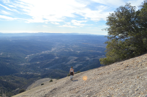
Finally, you reach the top, and the glory is yours to take in. Below you unfolds the Santa Ynez and all its tributaries, framed by patches of wineries and farmlands, the towns and tasting rooms all seeming small, with the Santa Ynez Mountains guarding the shining sea. So steep is Grass Mountain that you can’t even see its walls dropping down so sheerly beneath your feet. You could continue along the Zaca Ridge to reach Zaca Peak, though on a recent December visit a true trail was hard to discern and not worth the effort. Some have said it is a tradition to strip naked on the summit, though this is up to your discretion.
In all, the hike can be done in 2.5 or 3 hours and can be done year-round. Whether you ascend the mighty Grass Mountain for the beauty, the challenge, or the tradition of it all, it makes for an excellent day hike to test your endurance and to reward yourself with spectacular views.
For more information on the Midland School, visit midland-school.org/.
Information on Chumash villages and sacred sites credit goes to Joan Brandoff and Dan Reeves, “Shell Bead Production at Interior Chumash Villages” https://scahome.org/wp-content/uploads/2014/10/Proceedings.28Brandoff.pdf and Dr. J. Anderson, “Jonjonata: And Chumash Indian Traditionalism” http://www.angelfire.com/id/newpubs/jonjonata.html.


