Face-to-Face with the Scherpa Fire
Ray Ford Recounts the Last Two Days of the Santa Barbara Blaze

The fire began just after 3 p.m. on a sunny Wednesday afternoon in a small lot tucked between two houses on La Scherpa ranch near the crest of Refugio Road in the eastern Santa Ynez Mountains. The circumstances were eerily similar to those during the 1955 Refugio Fire, which broke out on September 6, 1955, just a few feet from this fire.
Though the cause of the Scherpa Fire hasn’t been made public yet, the focus has been on getting ahead of the blaze and slowing its rate of expansion down to the point that a combination of air attack resources, dozers, hand and engine crews, and hot shots can make a difference.
The air attack response was immediate — the heavy tankers, including a DC-10, helicopters, and smaller aircraft were on the fire within minutes. The Type 2 and 3 engines and dozers were not far behind. Firefighters focus every effort on putting maximum resources on the fire to slow things down so they can begin “building a box” around the flames using roads, dozer lines, hand lines, and the like to create a containment zone. In steep, rugged land like that along the eastern flank of the Santa Ynez Mountains, the challenge is immense.
The canyons line up from west to east: Refugio, Venadito, Corral, El Capitan, Gato, Las Varas, Dos Pueblos, and beyond to the Goleta Valley. The winds here have a tendency to push a fire to the east, and when combined with the sundowner winds that direct the force of the fire down-canyon and morning diurnal breezes that help push it back up-canyon, stopping the lateral move of the flames can be difficult at best.
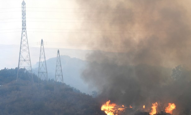
The fire quickly began moving eastward across the upper part of Refugio Canyon, expanding within an hour from 20 to 150 acres, and when the sundowner winds hit hard, the flames quickly turned down-canyon, blackening the eastern Refugio ridgeline and upper Venadito within a half mile of Highway 101 before the sundowner effect began to subside. In Corral and Las Flores canyons the fire pushed even further south to within several hundred yards of the highway before the winds abated there.
Thursday Morning Reconnaissance
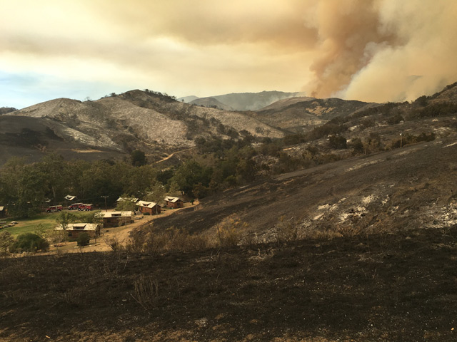
It became clear early in the morning Thursday that the fire had hit the upper part of Refugio, Venadito, and Las Flores canyons hard, with hundreds of acres of blackened hillsides still smoldering as the sun began to filter through the clouds of smoke. A tour of Venadito Canyon confirmed that no structures had been lost. The refrain was echoed in Refugio, Corral, and Las Flores: Hit hard but no losses.
“Today is a transition day,” said Chris Mailes, a battalion chief for the City of Santa Barbara Fire Department. “By that I mean that we’re moving from cooler temperatures to much hotter ones, with lower humidity and more difficult firefighting conditions.” Clearly, the goal was to hit the fire line even harder in the hopes of beginning to build a box that could contain the fire as the days grew hotter. Sadly, that was not to be the case.
Air Attack, Firing Out
Building a containment box in an area like the Gaviota Coast is nearly impossible. Refugio Road offers the potential to stop lateral movement to the west, but its narrow twisting character and thick roadside brush makes that a major challenge. East Camino Cielo is equally narrow and brush-covered. Sitting on the upper edge of an almost vertical headwall, it creates safety issues and the potential for embers to start fires on the north side of the road in equally inaccessible locations. To the south, Highway 101 and the ocean provide the only sure buffer, but at the potential cost of disrupting traffic, damaging orchards, and burning homes.
The most vulnerable side of the box lays to the east in the canyons, and it may be that eventual success will be found in using the ranch roads to create the buffers that can’t be created on the ridgelines, especially when the sundowner effects are in play.
“Last night we got a column shift a little after 6 p.m.,” Mailes told me. “The fire was no longer heading up and it was starting to turn down toward the ocean. That’s the first sign of a sundowner as it is starting to come up and over the mountain. Around 7 p.m. we started to get a downward push, and in a really short time, perhaps 20 minutes, we got a hard down-canyon push. By 9 p.m. the canyons were getting lit up.”
Fire strategy for the day was to focus on shoring up some of the weak parts of the box before Thursday’s sundowners came into play again. That meant laying down thousands of gallons of retardant on the eastern ridgelines, including those separating Refugio and Corral canyons and the Las Flores and El Capitan canyons and to begin firing out the most vulnerable parts of Refugio Road. The goal: keep the fire from spreading west across Refugio Canyon or east beyond Corral and Las Flores canyons.
Through midday, CAL FIRE crews burned out the narrowest parts of Refugio Canyon below Circle-Bar-B Ranch, and the assortment of jet aircraft made dozens of rounds on the eastern flank of the fire. By early afternoon, while the canyon fire-out was going extremely well, problems began to develop on the north and eastern flanks. The heavy smoke along the east side made retardant drops difficult. The fire also began to make a strong upward push, with two major columns developing, one heading back up Refugio Canyon towards La Scherpa Ranch and the other further to the east that posed a potential threat to Santa Ynez and Broadcast peaks. As a result, the air drops shifted from the east side of the fire line to the upper side.
Column Shift Begins
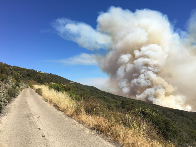
Just at the point where it appeared certain the fire would reach East Camino Cielo, with the major column within a half mile of the crest and climbing steadily, the wind began to pick up just after 4 p.m., causing the columns to turn east and break up. It was good news for the moment, but within a half hour, as the wind increased to 30-35 mph gusts, the column started to move away from the crest and down into the upper end of Corral Canyon. Above me, the air attack shifted once again, flying straight overhead, barely above the outstretched chaparral, laying down successive layers of retardant on the ridgeline immediately below me.
Just at the point where several of the tankers were lining up one after the other, including the DC-10, to continue the long red line of retardant, the increased winds began creating enough turbulence that they were called off for the day.
Prognosis for the Evening
I stopped and talked to one of the crew chiefs who was supervising the action from Camino Cielo. He was not happy. “Not been a good day for us,” he said. “The sundowner’s kicked in even earlier, and it looks like the fire will be in El Capitan Canyon tonight.” Then he added a kicker. “When we get the morning winds tomorrow, there’s a good chance the fire will hit the crest.”
It took me a bit longer to get down from the top of the mountains than I’d planned. Along the burnout area in Refugio Canyon a large oak came down and an engine crew was busily cutting it up and getting it off the road. It was dark by the time I got down to the highway. I turned east and took the frontage road toward El Capitan, wondering what things would look like. In the distance I spotted what looked like dozens of engines fully lit up, lining the road.
But as I got closer I realized the engine lights were actually the tops of rows and rows of flickering flames in the open areas near the Ocean Mesa RV park. El Capitan Canyon was fully engulfed. The fire in the upper canyon was intense and I worried about tents and cabins going up in flames. But rather than the fire engulfing the canyon, the firefighters were furiously pushing back, burning out the hillsides and turning the flames back.
There was a clearing in the middle that provided a safe zone, but the first impression was of being overrun by fire. Tree-high flames were burning within feet of some of the cabins, but within minutes the flames began to move away from the structures, uphill, and away from us.
The scene was incredibly eerie but it turned out that the back-firing operations may have ended up being one of the most effective tools in controlling fire in country where access to large parts of the fire perimeter is impossible.
Friday on the Line
Friday promised warmer temperatures and lighter wind, some good news and some not so good. Air attacks would hopefully hold the fire on the upper perimeter, and back-firing may serve to protect structures in Gato Canyon and further east.
As is often true in fires like this, the wind holds the key to success.