Santa Barbara County Officials Release Debris Flow Risk Map
Also Update Evacuation Terminology with Three Levels of Urgency

In the catastrophic wake of the “1/9 Debris Flow”— as public-safety officials are now calling the January 9 natural disaster in Montecito — the Santa Barbara County Office of Emergency Management (OEM) has launched a new interactive map designed to provide residents countywide with more precise evacuation information should another significant rainstorm bear down on the region this season or beyond.
Based on debris-flow analysis of the January disaster — which killed 21 people, with two others still unaccounted for — future evacuation advisories and orders will be rolled out according to where particular homes or businesses are located within or adjacent major Montecito watersheds, essentially all properties in the vicinities of Montecito, San Ysidro, and Romero creeks and their tributaries.
“We now need the public to go to this map,” urged OEM Director Rob Lewin, speaking at a press conference today at Montecito Fire Protection District headquarters. “We need to prepare for future storms. Let us not be fooled that the mountains have been flushed of debris.”
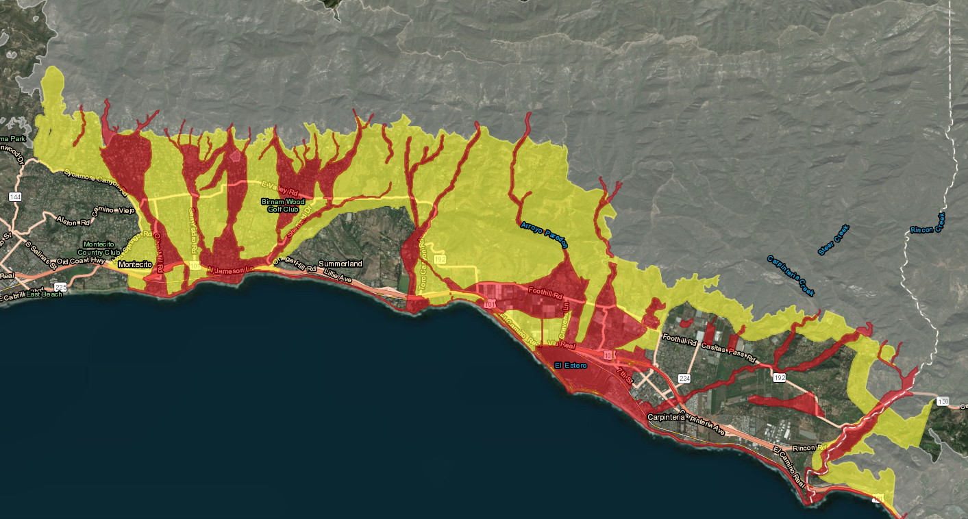
The county’s new Debris Flow Risk Areas Map is designed to show the possible reach of flooding and debris flows in the event of a storm producing more than half an inch of rain per hour. Delineated in red, properties within the footprint of the 1/9 Debris Flow are considered to be at “extreme risk” to suffer the same destruction should another big storm strike. Properties outside the footprint, in yellow, are likely to be surrounded by destruction — including impassable roads — and cut off from utilities; these areas are considered “high risk.” High and extreme risk zones stretch from Sycamore Canyon Road to the Ventura County line. They also exist in watersheds impacted by the Sherpa, Whittier, and Alamo fires.
The map is equipped to pinpoint any address countywide so that a resident, for example, can determine if he or she lives in an area deemed dangerous.
Sheriff Bill Brown also introduced the county’s new evacuation terminology, detailing three levels of urgency. If a major storm is on the way, he said, public-safety officials will first call a “pre-evacuation advisory,” meaning that residents ought prepare to leave and pay close attention to weather reports and emergency updates.
The next level is a “recommended evacuation warning,” he said, representing high risk for loss of life and property.
The third and final level is a “mandatory evacuation order,” meaning there’s an extreme risk for loss of life and property. “If you stay, it’s at your own peril,” Brown added.
Brown noted that none of the new terminology uses the word “voluntary” because during December and January evacuation events related to the Thomas Fire and subsequent debris flow, respectively, people tended to focus more on word “voluntary” than “evacuation.”
Also on hand, Montecito Fire Division Chief Kevin Taylor spelled out the sequence of events should potentially destructive storm appear in the forecast. 72 hours ahead of the storm, he said, public-safety officials will issue the pre-evacuation advisory. At the 48-hour mark, Sheriff Brown will issue the evacuation warning as first responders pre-stage in strategic, safe locations. When the storm is 12 hours away, the mandatory evacuation order will become effective. And in the final two hours before the storm hits, some surface streets will be closed and staging areas will be manned. At that point, added Captain Cindy Pontes with the California Highway Patrol, Highway 101 will be shut down in both directions between Milpas Street and Highway 150.
At this point, said Taylor, “The number-one thing people can do” is register for Aware and Prepare alerts at readysbc.org.