
Fire Command Considers Burning Out Backcountry
Entire Dick Smith Wilderness Inside Possible Burn Perimeter

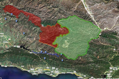
In a sign that fire command may not believe it can stop the fire from crossing the Santa Ynez River and moving to the front country, officials are looking into burning out a huge part of the Santa Barbara backcountry.
With high temperatures and low humidity predicted for the next three days, operations leaders decided are considering a strategy they hoped they’d never have to use: circling the entire fire boundary and burning back into it. This represents an expansion of the fire perimeter that could encompass an additional several hundred thousand acres.
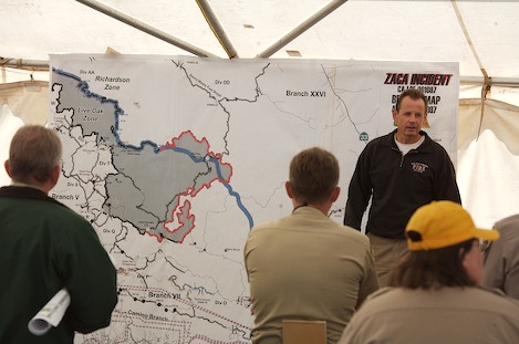
At the morning cooperators meeting this morning, Incident Commanders Mark Schmitt and Bill Molumby told those present the burn, once started, would take 10-14 days and could begin on the north part of the fire line as soon as resources were in place and on the south side as early as Monday. County public information officer William Boyer, however, noted in a later interview that no decision has been made in the matter and that the back country burn was still only a move crews were considering.
In somber terms, Molumby, who is the Incident Commander for the Forest Service Type 1 team, described a boundary that could include all of the Dick Smith Wilderness, close Highway 33 near Ozena at times and turn what is now an 80,000 acres fire into one that could consume a large part of Santa Barbara County.
“Once you pull the switch,” Molumby told the stunned crowd, “there’s no turning back.”
“All we need to begin the burning is to get the logistical pieces in place,” Schmitt added. “We’d planned on starting the burn on the north side along the Sierra Madre crest but we weren’t quite ready.”
Operations leaders expect that about 60-70 percent of the country inside the perimeter would burn. “We’ll have a black edge on the boundary but there’ll be lots of islands inside it that won’t burn.” Molumby explained.
With large portions of the San Rafael Wilderness already burned, the impacts on wildlife and watershed quality will be immense as well as the amount of smoke, ash and other particulates that will be released when an area this size burns.
Tonight, another in the series of community meetings will be held at the Museum of Natural History. Meeting time is 6 p.m. Perhaps more explanation of the burn out will be given then.
On the lower front of the fire, there was additional movement on the fire line, with flames moving over Pie Canyon Jeepway and down into the wilderness near Indian Camp.
On the upper fire line, the fire made headway into the Sisquoc drainage, expanding both down to the river and west towards Rattlesnake Canyon.


