
Zaca Fire Threatens to Move into Ventura County
Spot Fire Causes Fire to Jump a Small Section of Monte Arido Ridge

For the Record
171,750 acres burned
16,305 burned last 24 hours
Cost:$78.5 million
“A good plan executed today is better than a perfect plan executed tomorrow.” – General George Patton Jr.
Jumping the Line
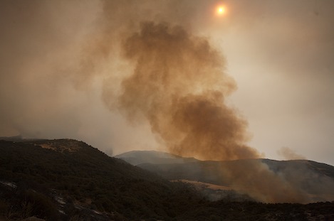
For most of the morning yesterday, smoke-filled skies made it difficult for operations leaders to see exactly how much of the Agua Caliente drainage had been burned.
Near Ogilvy Ranch in Mono Creek, hand crews were working hard to contain the fire along a ridge leading east to the Hildreth Jeepway, but nobody new for sure what was happening In Agua Caliente.
In the early afternoon when the inversion layer lifted, and with a bit more visibility, forward observers (FOBs) could see the fire had moved down into the canyon and was working its way south into Diablo Canyon. By 2pm, with the winds picking up in the canyons, the fire began a major run east directly up Agua Caliente.
One of those at Live Oak told me the radio traffic was intense. “From 2-4pm the reports coming back to us were that we’d lost the Monte Arido ridge. By 5pm, however, we got the word we’d held the ridge.”
The commotion heard on the radios was focused on a section of the Monte Arido ridge where the fire had jumped the line. Two hundred acres had burned into Matilija Wilderness on the Ventura side before air attack could get a handle on it. Without any hand crews in the area, everyone thought the ridge was a goner, but with an intense air attack out in front of the slopover they were able to check it – at least for the evening.
An Intense Afternoon
At the morning briefing this morning, quoting Patton, Incident Commander Bill Molumby reminded the assembled fire fighters that despite the setbacks the contingency plans set in place more than a month ago still provided plenty of opportunities to check the fire.
“Immediately we had back firing in place along our pre-established lines and had good success controlling the fire’s movement down Mono Creek near Ogilvy Ranch.” Because the fire was putting up such a large plume in Agua Caliente Canyon, they were also able to backfire from the air using heli-torches along several miles of the Monte Arido ridgeline.
With the force of the fire directed up into the plume, once the torches had lit the upper slopes rather than running uphill as they might normally do the flames were sucked downhill into the plume.
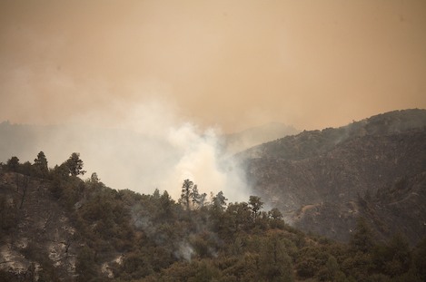
This is typical of backfiring operations where the fire will be ignited lower down on the slopes, allowed to build into a column, and then the upper slopes selectively burned so the uphill fire is drawn into the downhill fire, thereby moving it away from the containment line.
New Evacuation Warning
Due to the increased fire activity, at 8pm last night the Santa Barbara County Sheriffs Department and fire authorities issued an “EVACUATION WARNING” for East Camino Cielo Road from Gibraltar Road east to the Ventura County Line. Ironically, with the exception of caretakers at Gibraltar Reservoir and Jameson Lake, no one lives in the area covered by the warning.
However, as a sign the County is taking the fire’s potential to reach the front country, fire crews and dozers were sent up the old Romero Canyon Road that leads up to Romero Saddle. Reports are the upper part of the road, now a favorite single-track ride of mountain bikers, is being bladed out to the top.
Despite these precautions, it should be notes that the fire’s predominant movement continues to the east and northeast in a direction that is placing far more pressure on the Ventura County line above Matilija Canyon than on the Santa Ynez Mountains.
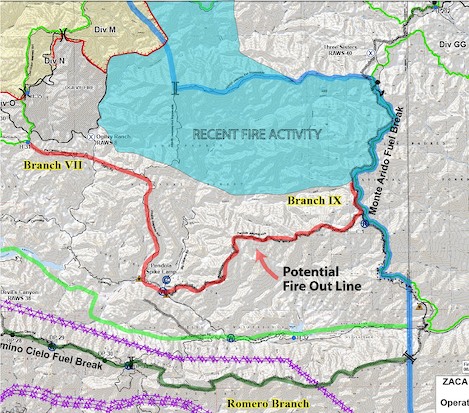
Note the potential back fire line in red along with the two "fallback" lines in lighter and darker green (Santa Ynez River and SY Mountain crest). The fire is much more of a threat to continue southeast into Matilija Canyon than turn back towards Santa Barbara. (Edits added to the map by Ray Ford.)
On the south edge of the fire, Operations is looking at back firing along the Pendola Jeepway today. The 10-mile long route leads from the 6,003 foot crest of Monte Arido down to Pendola Station. “We have a tough day ahead of us,” one of the operations leaders reported at the morning briefing. “There are a lot of pieces we need to hold.”
As outgoing County Incident Commander Mark Schmitt put it, “The fire hasn’t given it an inch. But then we haven’t given it an inch either.”


