Touring Santa Barbara County’s Fire Danger
A Firsthand Look at Where Will Burn Next
While much of Southern California was on high alert this week because of the potential of Santa Ana winds in the region – the troublemaker spreading the fire to burn hundreds of thousands of acres last month – Santa Barbara fire officials continue to keep their eye on trouble spots around the county, and are doing much to keep the public informed of the dangers surrounding their homes.
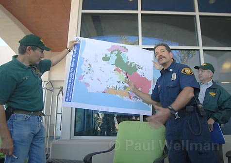
A lot of people don’t realize the dangers in this county, County Fire Capt. Eli Iskow said. “We want to make people think about safety.” And that’s why Iskow recently brought along several Santa Barbara media outlets for a flight all over Santa Barbara County to look at the county’s fire conditions and concerns, as well as view the paths of past fires in the county.
While the Zaca Fire scorched more than 240,000 acres over the summer – the most in county history and the second most in state history – there is still plenty of fresh fuel for large and dangerous fires throughout the county. And so we took off last Thursday from Santa Barbara Airport in a small, single-engine Cessna plane with Santa Barbara County Sheriff’s Department Aero Squadrons to check some of the hot spots around the county still facing fire danger.
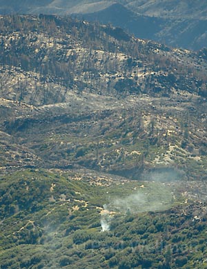
We began by heading north and west to the community of Cebada, amidst the wine grape-laden Santa Rita Hills. On this picture perfect day from 8,000 feet, the potential for fire is obvious. The green splotches of thick brush are here, there, and everywhere, and in some areas haven’t burned for quite some time, meaning they are fuel for a potentially serious fire. Though there are only a few hundred homes on the hill of the community, the residences are pretty much isolated when it comes to road access. That means if there’s an emergency situation in these neighborhoods, namely a fire, county rescue will have a difficult getting into the area, while residents may have a hard time getting out. “There’s one road in,” Iskow said. “If it’s blocked they have nowhere to go.”
From Cebeda we headed north and a little bit east to Tepusquet Peak, not far east from Santa Maria between the Sisquoc River and Highway 166. On the way we could see the burn scars from the Cemetery Fire, which began in August not far from the city of Lompoc. The fire ended up burning to the south, but if the wind had turned the other way, Iskow said, it would’ve gone straight into Lompoc.
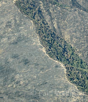
The canyon of Tepusquet Peak is a very high risk area, Iskow said. Running down from the peak you can see very thick brush heavily covering the canyon, and it’s obvious a fire in that area could quickly lead to trouble. About 200 homes sit in the canyon or at the bottom. The area hasn’t had a fire in about 80 years, which means the brush is ripe fuel for fire. The closest station is in Sisquoc Valley – not close to the area. “We’re not going to be there in time for a serious fire,” Iskow said. “There’s just no way.”
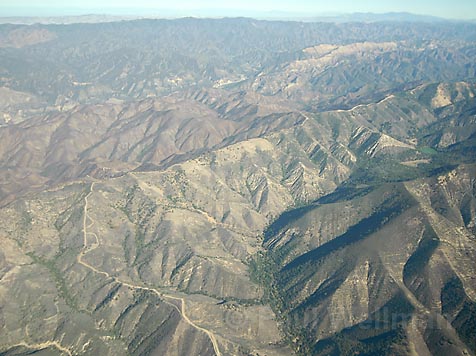
As we head to Cuyama Peak, the burn scar from the 1966 Wellman Fire, the last major fire in the San Rafael Wilderness, is still evident. That fire consumed more than 93,000 acres. Along the way we reach a point where Iskow notes that for the next 44 miles to the east, all the ground is scorched as a result of the Zaca Fire. The ground is brown and dead, with no signs of life and just little splotches of green remaining.
One of the pilots in another plane sees smoke to the south, 1.5 miles east of San Rafael Peak, and a couple of planes go to investigate. There’s speculation that it is just a hot spot remaining from the Zaca Fire, and that’s what it turns out to be. There are still islands of unburned land in the rugged country that will catch fire, but there is no way for it to spread, so it just burns. Iskow says this will continue until heavy rains come to extinguish the hot spots.
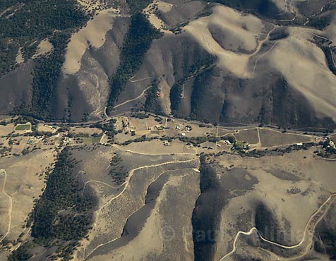
After cruising over Cuyama Peak, we fly to Gibraltar Reservoir, where much of the surrounding land is burnt. With a lot of rain, Iskow explains, the silt leftover from the Zaca Fire will flow into the surrounding watersheds and deteriorate water quality. Just mountain ridges to the north and south could also be seen, which fire officials used as areas to stop the Zaca Fire from spreading. “We had explosive potential,” Iskow said, noting that some flames reached several hundred feet in the air.
If the wind had caught the flames, they could’ve pushed over the north ridge and continued on far into the wilderness. The canyons in these areas were burning at a rate of 5,000 to 12,000 acres a day, which led to those huge smoke plumes being seen in Santa Barbara over the summer, Iskow explained. “There’s nothing you can do but back off and create a firebreak.”
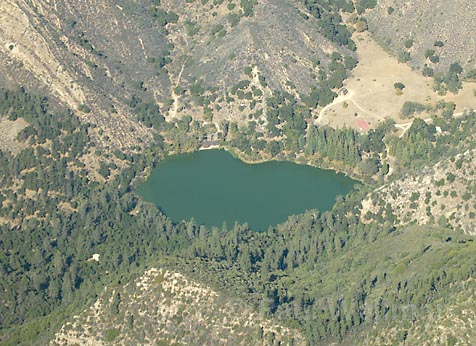
After a look at the area where the fire started, not far from Zaca Lake, which has a fair amount of brush fuel surrounding it, we headed to the Woodstock area east of Los Olivos off Highway 154, not far from October’s Sedgwick Fire, which covered 750 acres with a push from Santa Ana winds on the same day many of the more impacting Southern California fires began. The scar of the fire which put almost 400 homes in danger was visible. The fire could’ve done much more damage, but winds died down enough for firefighters to gain control.
The area has the same potential to cause devastation as the 1990 Painted Cave Fire, which swept through the neighborhood from San Marcos Pass to the Hope Ranch area in only 30 minutes. We had flown over Painted Cave earlier, and could see remnants and burn scars still there.
As we returned to Santa Barbara Airport, I realized I had seen firsthand what I had been hearing from the County Fire Department for weeks and months now – the potential for fire was all too real. This media flight was scheduled to take place July 1, three days before the Zaca Fire began. It was called off because many firefighting resources were consumed fighting the Ranch Fire in the North County. Those two fires are just two of several which have consumed several hundred thousand acres throughout the county this summer and fall.
And while many of the fires in Santa Barbara County steered clear of populated areas and structures, the devastation in Southern California has made people even more cognizant of what can happen when these fires happen in populated areas. With this in mind, Iskow said, it is important for people to be ready. People living in the areas mentioned above, and even those not, should be prepared by creating a wildfire action plan.
Go to SBCFire.com for more information on what should be included in the plan, and how to make sure your family and neighborhood are prepared.