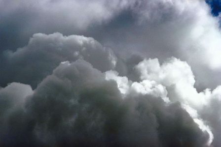
National Weather Service Predicts El Ni±o Winter
Current Weather Conditions Indicate Future Wetness and Wildness
It may be hot, sunny, and dry right now but folks from the National Weather Service say Santa Barbara could be in for a change once late fall rolls around.
Based on current sea surface temperatures in the equatorial waters of the Pacific Ocean, meteorologists are ringing an alarm the world over about the imminent return of El Ni±o, that often bemoaned weather cycle that typically delivers wet, wild, and warm storms all winter long to the coast of Southern California and record snowfall to the Sierras. “Earlier this summer [an El Ni±o pattern] was a potential,” explained National Weather Service meteorologist Eric Boldt, “but now it appears to be imminent. We just don’t know how strong of one it will be.”
A reason for celebration among surfers and a reason to batten down the hatches for most others, El Ni±o is the technical term used to describe the somewhat mysterious weather trend of surface water temperatures increasing above normal in the tropical waters of the Pacific. Since the belt of the Pacific essentially powers the winds of the world, a jump in temperatures there often results in a tweak to global weather patterns. Locally, these mood swings historically spell a lower-flowing jet stream that delivers Santa Barbara’s south-facing coastline the kind of big winter storms that have been missing in Santa Barbara the past two years, thanks to the high-riding jet stream that is the calling card of El Ni±o’s sisterly inverse, La Ni±a. “In and of itself, El Ni±o doesn’t guarantee anything weather wise, but [since we began studying it in the 1950s] it has proven to bring more intense storms to Southern California throughout the winter season,” Boldt explained.
Like most weather phenomena, El Ni±o comes in degrees of intensity that correspond to how much warmer equatorial waters become. According to Boldt, it takes an increase of about a half-degree Celsius from normal readings to get meteorologists talking about El Ni±o, but it isn’t until you have three consecutive months of these higher-than-normal temps that El Ni±o becomes official. Currently, we are about nine weeks into above-average readings – including some well above-average – said Boldt, who suggested that by September we will know just how real and severe this current incarnation of El Ni±o is.
For a point of comparison, the last two El Ni±o events, the winters of 2006-7 and 2004-5, were both “weak” ones, with the latter still dropping record rainfall amounts for many areas and the former amounting to one of the driest “rainy” seasons in recent memory in Southern California. While the 1997-98 El Ni±o, the one that seems to live on in the memories of Southern California residents, and especially surfers, as being the biggest and baddest of the past 20 years, was considered a “strong” version of El Ni±o. In Boldt’s estimation, current readings are trending, that is if patterns hold, towards a “moderate to strong” El Ni±o for this winter.
As recently as late May, the folks from the National Oceanic and Atmospheric Administration (NOAA) were forecasting a roughly 50 percent chance of an entering an El Ni±o cycle. However, as June recordings filed in, the sea surface temps started to go a bit bonkers, leaping 0.5 to 1.5 degrees Celsius above normal and the El Ni±o buzz began. While some forecasts have in recent weeks downplayed the formation as a result of a slight cooling of key temperature readings, there is no doubt, based on current NOAA charts, that temperatures are still above average.
Perhaps more telling is the anecdotal evidence being talked about in harbors and surf spot parking lots throughout Southern California. Tales of unusually warm water temps and sightings of such animals as sea turtles and yellowtail tuna in stretches of ocean that usually don’t see such life except during El Ni±o cycles have been commonplace for much of the past month from Pt. Conception to San Diego. “Everything is definitely warmer than normal right now,” Boldt said. “Now we just have to wait and see how things look in September.”