
Erratic Winds Push La Brea Fire North and West
Additional 10,000 Acres Burned by Midnight Tonight

Just when firefighters thought they had a handle on the slopovers in Moon, Spoor, and Eckert canyons on the Cuyama side of the Sierra Madre Ridge and the west edge of the fire, 50 mph nighttime winds pushed La Brea Fire all over the place.
The result was an additional 5,000 acres of chaparral burned last night and what appears to be another 5,000 acres today. By tomorrow morning, fire officials expect the total acreage burned to exceed 30,000 acres. In wilderness that might not sound like much, but just this day’s losses would exceed the acreage burned in the Gap or Jesusita fires by about 20 percent. The difference is that neither communities nor homes, fortunately, are directly threatened.
So what happened today? One might actually ask, “What didn’t happen?” Despite the unpredictable winds, the fire did not take off in an easterly direction and follow the Sisquoc drainage upstream. Winds generally follow topography and drainages so one might have expected the fire to head east as it did during the Zaca Fire. If it had done this, an additional 40,000-60,000 acres might have burned. That may still happen, but it isn’t clear from today’s action that it will.
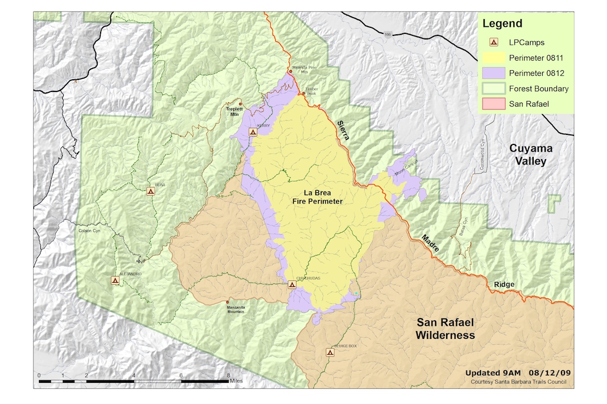
What did happen is that the winds pushed the fire further downhill into the Cuyama Valley and, actually, just over the forest boundary, so this is now technically both a federal and state lands fire. I’m told that a number of the local TV stations warned viewers that the flames were beginning to threaten homes, but I’m not thinking this is the case. The area in possible danger is below Moon and Eckert canyons toward the Cottonwood Canyon area This is pretty flat country with lots of grassland, oaks, and homes that are small and scattered – pretty easy country for CDF engines to protect. Backfiring will be easy, if needed.
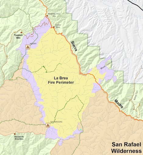
More of concern could be the south and west flanks of the fire. As one might surmise from the map shown above, the half-mile thick ring of purple tells the story. The fire is slowly chewing up chaparral all around the edges and slowly moving outward. Neither of these edges is moving directly toward homes in the Tespusquet Canyon area, so that is very good news.
But what it is doing is heading downhill towards the Sisquoc along La Brea drainages toward the Sisquoc and northwest toward Highway 166. Either of these flanks of the fire could eventually cause problems, but not tonight and, if so, not for days. And the good news that what was true yesterday – and still is today – is that the fire continues to be centered in 80-year-old brush. This creates headaches for firefighters and lots of fireworks, but as the flanks expand outward, eventually conditions will shift to favor those who are doing everything they can to keep the fire under control.
That is, of course, if that evil east wind doesn’t show up and push the fire up the Sisquoc in the next few days.
Stay tuned.


