Easter Earthquake Rumble
Mexico-Centered Quake of 6.9 Shakes Locally

An earthquake registering 6.9 on the Richter scale hit 16 miles south of Guadalupe Victoria, Baja California, Mexico, and was felt locally at approximately 3:45 p.m. Sunday afternoon. The official time of the earthquake was Sunday, April 4, 2010, at 3:40:39pm
The NOAA/ NWS/ West Coast and Alaska Tsunami Warning Center has issued a statement regarding potential tsunamis: “A strong earthquake has occurred, but a tsunami IS NOT expected along the California, Oregon, Washington, British Columbia, or Alaska coast. NO tsunami warning, watch, or advisory is in effect for these areas.
“Based on the earthquake magnitude and historic tsunami records, a damaging tsunami IS NOT expected along the California, Oregon, Washington, British Columbia, and Alaska coasts. Some of these areas may experience non-damaging sea level changes. At coastal locations which have experienced strong ground shaking, local tsunamis are possible due to underwater landslides.
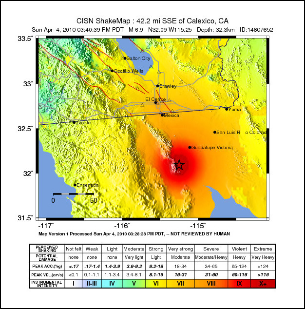
“At 3:41 PM Pacific Daylight Time on April 4, an earthquake with preliminary magnitude 7.0 occurred 45 miles/72 Km southeast of El Centro, California.”
Centered approximately 108 miles east of Tijuana, the quake shook local Santa Barbara homes mildly, pools splashed, and residents and their animals grew uneasy. At this time, no damages have been reported. We will post any futher information as it becomes available.
Updated, 5:02pm: Magnitude of the quake has been raised to 7.2 Mw.
Update, April 5, 8am, from USGS: Tectonic Summary
The magnitude 7.2 northern Baja California earthquake of Sunday April 4th 2010, occurred approximately 40 miles south of the Mexico-USA border at shallow depth along the principal plate boundary between the North American and Pacific plates. This is an area with a high level of historical seismicity, and also it has recently been seismically active, though this is the largest event to strike in this area since 1892. Today’s earthquake appears to have been larger than the M 6.9 earthquake in 1940 or any of the early 20th century events (e.g., 1915 and 1934) in this region of northern Baja California.
At the latitude of the earthquake, the Pacific plate moves northwest with respect to the North America plate at about 45 mm/y. The principal plate boundary in northern Baja California consists of a series of northwest-trending strike-slip (transform) faults that are separated by pull-apart basins. The faults are distinct from, but parallel to, strands of the San Andreas fault system. The April 4 main-shock occurred along a strike-slip segment of the plate boundary that coincides with the southeastern part of the Laguna Salada fault. Although the location and focal-mechanism of the earthquake are consistent with the shock having occurred on this fault, we do not yet have surface rupture or other confirmation. Aftershocks appear to extend in both directions along this fault system from the epicenter of today’s event. The aftershock zone extends from the northern tip of the Gulf of California to the Mexico-USA border.
Earthquakes having magnitudes as high as 7 have been historically recorded from the section of the Pacific/North American plate boundary on which the 4 April 2010 earthquake occurred. The 1892 earthquake occurred along the Laguna Salada fault system, but significantly farther northwest than today’s event epicenter. The 1940 Imperial Valley earthquake approached magnitude 7, though it occurred farther to the north and on the Imperial fault. Both the 1892 and 1940 earthquakes were associated with extensive surface faulting. An event of M 7.0 or 7.1 occurred in this region in 1915, and then a M 7.0 to 7.2 in 1934 broke the Cerro Prieto fault with up to several meters of surface slip.
In the vicinity of the 4 April 2010 earthquake, there are several active faults and it has not yet been determined specifically which fault the earthquake occurred on. Within the transition from the ridge-transform boundary in the Gulf of California to the continental transform boundary in the Salton Trough, faulting is complex. Most of the major active faults are northwest-southeast oriented right-lateral strike-slip faults that are common in mechanism to the San Andreas fault and parallel Elsinore and San Jacinto faults, that run north of the Mexico-USA border.