
White Fire Blackens Backcountry
A Personal Report and Collection of Stats from the Wildland Blaze

The early afternoon of a beautiful Memorial Day Monday turned ugly when flames that erupted from the White Rock Day Use Area along the Santa Ynez River were driven north across the river and began climbing up the slopes of Sage Hill within minutes. Winds were averaging 20-25 mph with gusts 10-15 mph above that.
Though it hasn’t been confirmed, the fire was reportedly started by an unidentified man who scattered spent BBQ coals on a patch of dry grass. Witnesses said they saw the man quickly depart the area when the grass caught fire. Despite requests that County Fire spokesperson Captain David Sadecki speak about these rumors, he has yet to comment on them.
The immediate concern was for canyon residents and the hundreds of campers and day use groups who had flocked to the Santa Ynez River. One couple who had ridden their mountain bikes from Upper Oso up and over a nearby trail called the Camuesa Connector barely escaped when they looped back along the river and attempted to ride back up to Upper Oso where their car was parked. Santa Barbara County Search & Rescue members were able to drive in and bring the car down to the distraught pair. They helped numerous others evacuate. Around 6,000 people in total fled the area with approximately 600 firefighters from numerous agencies descending on the scene.
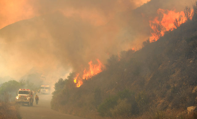
As I drove into the area shortly after the White Fire became a full-fledged emergency, I could see a steady stream of cars exiting the canyon. There were others who were allowed to drive in past the road closure near Fremont Camp to rescue horses that were pastured in the canyon. East of the White Rock Day Use Area, I was amazed by the fire’s impact. From that point all the way to the first river crossing, almost all of the vegetation in the riverbed and hillsides north of it had been burned to the ground. Several engine crews were in the process of mopping up along the road just before the Los Prietos Boys Camp where they had barely kept the fire from crossing to the south side and creating infinitely more problems.
Heading across the river to the Lower Oso Picnic Area, I spotted small fires along the road, and when I turned and went up toward Upper Oso, I could see billowing black clouds of smoke, swirling angrily as they headed hundreds of feet into the air. Continuing further I could see that parts of the Upper Oso area were completely engulfed in flames, with several of the steeper hillsides filled with 40- to 50-foot-high walls of fire.
Throughout the canyon one could see spot fires, walls of flame, and burning oak trees and fields of grass all situated in steep, rugged, and mostly inaccessible topography. I knew there were few roads into the mountainous country north of the river and that the fire would be difficult to contain. The good news, at that moment, was that evacuations went well and as the fire moved eastward it minimized the danger it would jump the river and threaten canyon homes or the Painted Cave area.
The fire — as of press time — has stayed high, on the north side of the river, and has moved east of Oso Canyon to a point about where Falls Picnic area is located at the second river crossing. There are numerous engine and hot-shot crews stationed along the river road to ensure the fire does not spread across it and to knock down small hot spots that burn here and there above them.
By the end of the day Monday, it was unclear what the morning would hold. From the river’s edge, everything seemed calm, but in the hotspot areas such as Upper Oso or upper Aliso Canyon north of the ranger station, firefighters were battling massive walls of flames. A warming trend is predicted for the next few days, but it will be the wind that could determine whether the White Fire has a short shelf life or becomes something more powerful and dangerous. The goal, however, is clear: keep the fire north of the river at all costs until weather conditions are more favorable to contain it. “It’s only May,” one firefighter exclaimed, “and we are two months ahead of typical fire conditions.”
Tuesday morning brought hope. The past evening’s ferocious winds had died down, and cloud cover helped keep the temperatures down and the humidity up. During a morning briefing with fire officials, they explained the White Fire had grown to 1,800 acres and was barely 10 percent contained. Armed with shovels, chainsaws, and bulldozers and backed by a small air force of six air tankers and seven helicopters, responders would focus on perimeter control and keeping the fire on the north side of Paradise Road.
Whereas Monday was occupied with evacuation efforts and structure protection, Capt. Sadecki said, “As soon as the fog lifts, the tankers and helicopters will begin bombing the eastern flank of the fire with chemical retardant and water scooped from nearby reservoirs.” Sadecki also noted the eastern side is open wildland, with “nothing but vegetation … no houses, no improvements.” Without having to worry about homes or people, the day’s task was to pour water and retardant on the eastern side of the fire to the point that hot-shot crews could make their way over a series of ridges, canyons, steep terrain, and loose, rocky soil to establish a two-mile-long line to tie in with the river road and the Buckhorn-Camuesa Jeepway.
As I made my way up the Santa Ynez River Canyon on Tuesday, the difference was remarkable. Rather than thundering mountains of fire, smoke, and ash, the hillsides were dotted with wisps of smoke and an occasional burst of flame. After quick drives along the river and the Upper Oso area, it became clear that the firefighters, with massive amounts of aerial support, had been able to establish reasonably secure perimeters around two triangle-shaped areas within which the fire was then burning, east and west of the Upper Oso drainage. Of the two, the triangle marked by the ranger station, Alison Canyon, Oso Canyon, and the river still had plenty of fuel to be burned within it but little capacity for the fire to jump its lines.
More good news came when I crossed the river east of Falls Picnic Area to check out the area east of the Upper Oso drainage. Fire crews had containment lines all along the river, and it was clear the fire was no longer moving eastward and was now heading further into the interior. At this point I reversed course and headed back over to Upper Oso and worked my way up the Buckhorn Jeepway, an extremely steep, narrow and rugged dirt road that leads up to Little Pine Mountain.
The effectiveness of air support often depends on what is happening with the winds. Tuesday, the wind had slacked off, but every few minutes it gusted to 20-plus mph — at least at ground level. Jim Kunkle, who runs the Santa Maria Airport tanker base, said the tankers had been grounded for about an hour because of high winds and turbulence in the canyons. In the two hours I spent up there, the newest plane in the firefighting arsenal — a Neptune BAE 146 — made three drops. The plane is an actual jet, not quite the size of a DC-10, but it has the capacity to carry a load of between 3,000-5,000 gallons.
The Neptune doesn’t appear that big in the sky until you notice the lead plane, which looks more like a gnat leading a charging warrior into the fray. The jet circled twice clockwise, then after a second pass curved right into a counter-clockwise pattern circling a long ridge off to the east. Then it came charging over the ridge and dipped down, dropping toward the knoll I’m on before lifting upward and releasing its payload.
The pattern continued on as more and more drops were made; and while they were, reinforcements came in the form of dozens more hot shots on the ground who followed the aerial act. Their job was to cut about two miles of hand line more or less over a series of ridges and canyons to tie in the final piece that could lead to full containment. Though it may take a few days, it appeared on Tuesday afternoon that the course of this battle may be shifting our way.
Tuesday night, Forest Service officials said that while the fire had grown to 2,025 acres, it was 65 percent contained and residents were being allowed to return to their homes.


