How the Thomas Fire Quickly Became the Fourth Largest Wildfire to Burn in California
242,500 Have Gone Up in Flames Across Two Counties

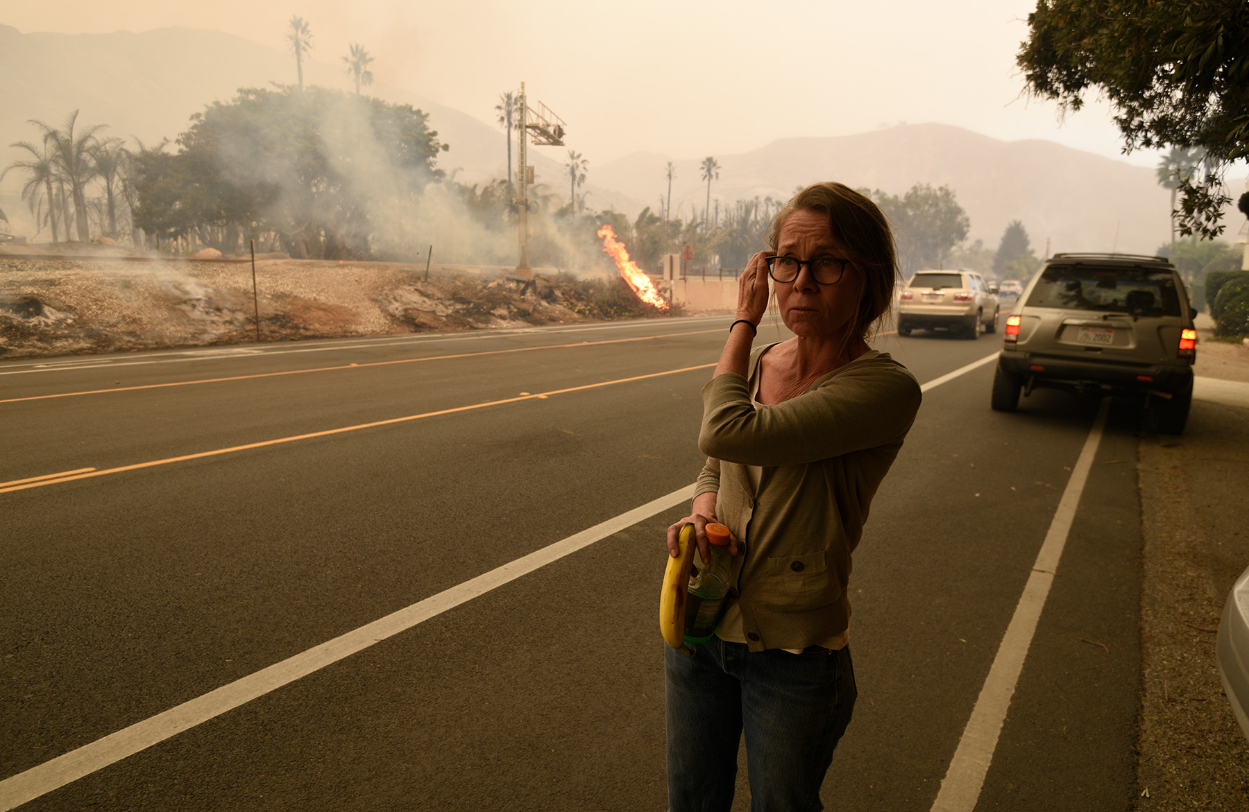
At the corner of San Andres and Micheltorena streets on the city’s Westside, a lone street preacher holds forth as wisps of ash dance from his ankles to his knees. A few phantom cars whoosh by. The air is choked with the incinerated remains of nearly 1,000 burned-down homes and who-knows-how-many millions of plants and animals. The preacher’s voice — magnified by a portable PA system — cracks with amplified distortion. No one stops to listen. A young man carrying a plastic bag of tangerines — his face obliterated by a blue respirator mask — appears on a skateboard, gliding silently past. He doesn’t slow down. It’s the same old sermon, after all: fire and brimstone.
But on this muffled morning, it also happens to be the weather report.
Welcome to the Thomas Fire.
Santa Barbara may be the land of milk and honey, but it’s also become the land of the perpetual fire drill. Ten years ago, when Arnold Schwarzenegger was still California’s governor, Santa Barbara learned the hard way that fire season had expanded into a year-round event. We had three wildfires and three mass evacuations within 18 months. You’d think we’d be used to it by now.
But every fire is new.
Every fire is different.
And every fire is profoundly disturbing.
The Thomas Fire started out in Ventura County just outside the City of Santa Paula on the evening of Monday, December 4. Incidentally, that is the feast day of Saint Barbara, our city’s namesake, who, back in the day, was the patron saint of those facing imminent peril. But this fire is named after another Catholic saint, Thomas Aquinas. That’s the name of a small Catholic college where the fire originated.
Since its inception, the Thomas Fire has proved voracious. On day one, it gobbled up 65,000 acres. Fueled by Santa Ana winds, it spread 15 miles, eating up the equivalent of an acre per second. On Saturday, it traveled six miles. A few days later, it grew by 61,000 acres; on another by 50,000. On any one of those days, County Fire Chief Eric Peterson told the county Board of Supervisors, it burned more acreage than the recent Sherpa, White, and Alamo fires combined. “This is historic,” said Peterson. “Unprecedented.”
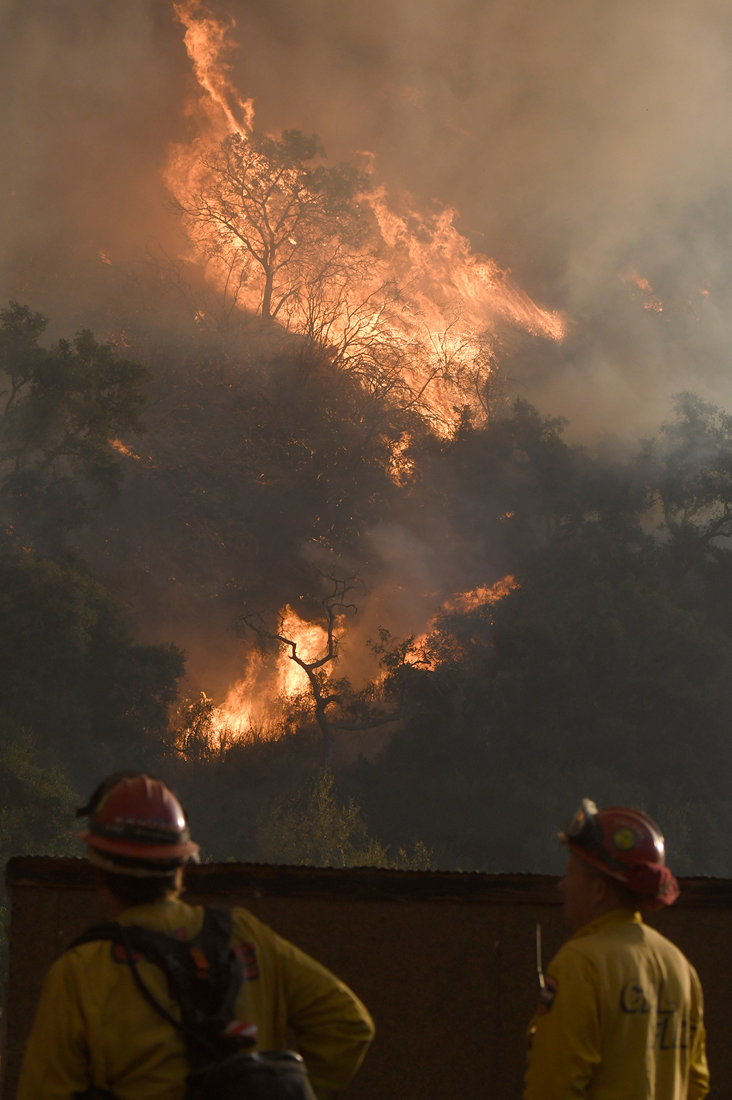
The Thomas Fire got so big so fast that even the trained professionals have had a hard time keeping up. During a recent community forum at the San Marcos High School auditorium, the heads of all the firefighting agencies battling the Thomas sought to reassure everyone they had the “best firefighters on the planet.” This forum, like many public presentations before and after, is designed to win public trust — critical if residents can be expected to evacuate when the mandatory order is given. Mandatory evacuation orders have been issued in neighborhoods from Ventura to Montecito. But accurate information is difficult to come by in a fire as fast as this one. Even these ranking top brass had trouble agreeing on the number of acres consumed by the fire. One said it was 173,000, another said 200,000, and a third insisted it was 220,000. By the end they all estimated it had hit 225,000 acres.
What people really need to know — both firefighters and neighborhood residents — is the exact location of the fire. On Tuesday evening, eight days after the Thomas began, there is at last a map in which residents can type in their addresses and find out how close the fire is from their homes. This is thanks to Santa Barbara Fire Chief Pat McElroy, who realized such information was needed. Working through the unified command, the map was designed and launched within 24 hours. It’s tough convincing people to leave their homes when it is still safe — before they see the actual flames pouring into their backyards. But by then, of course, it is too late. McElroy hopes this will help persuade them to believe the mandatory evacuation order when it comes.
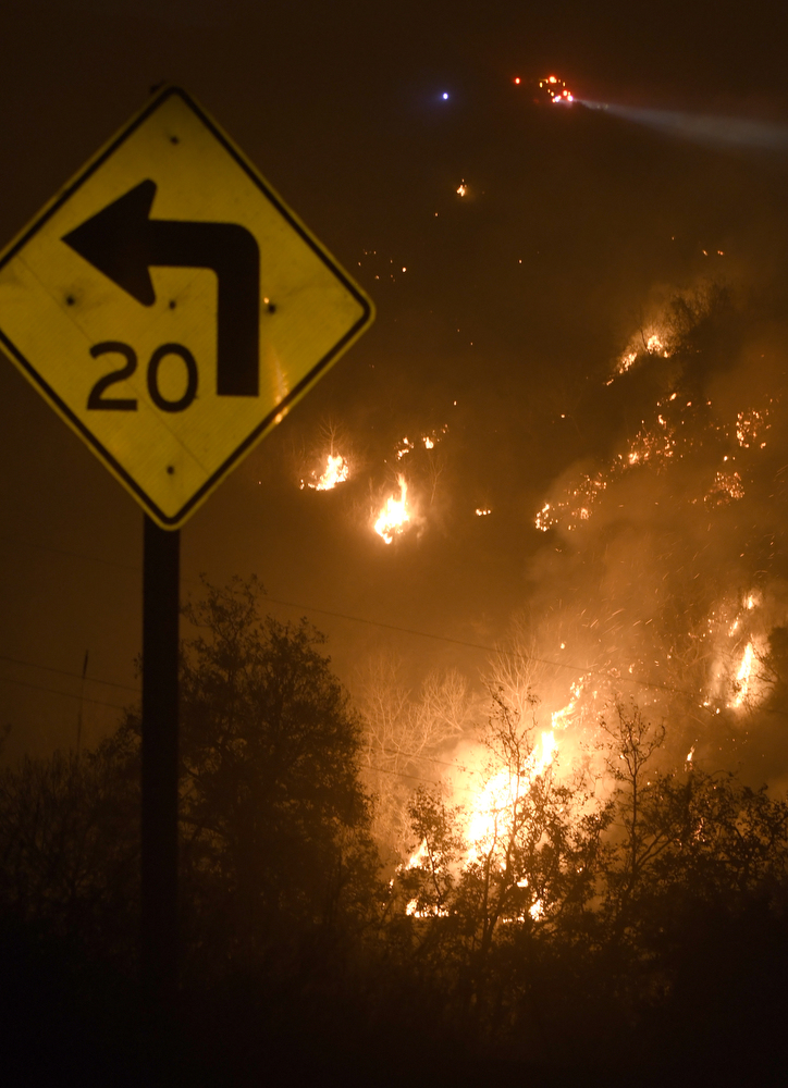
With a fire like the Thomas, time is of the essence. It has already leapt across Highway 33, destroyed hundreds of homes in Ventura, jumped over Highway 150, and even — a few times — reached across the 101 freeway, incinerating, among other things, the lush palm-tree nursery on the Pacific side. On Tuesday night, when the Santa Ana winds had died down a bit, Incident Command was confronting whether they would be able to stop those same winds from pushing the Thomas Fire downslope past Highway 192. That’s the heart of Montecito and the pathway to the City of Santa Barbara. It’s where most of the people are.
Santa Ana winds blow out of the north and push down the mountainsides. In Santa Barbara, we don’t usually see them in December. Occasionally. But what had never happened before is a continual blast of Santa Ana winds blowing day after day after day. “We used to be able to say with some certainty, ‘Fires will do this.’ Or ‘Fires will do that,” said Chief McElroy. “That’s not true anymore. That’s what’s scaring people.”
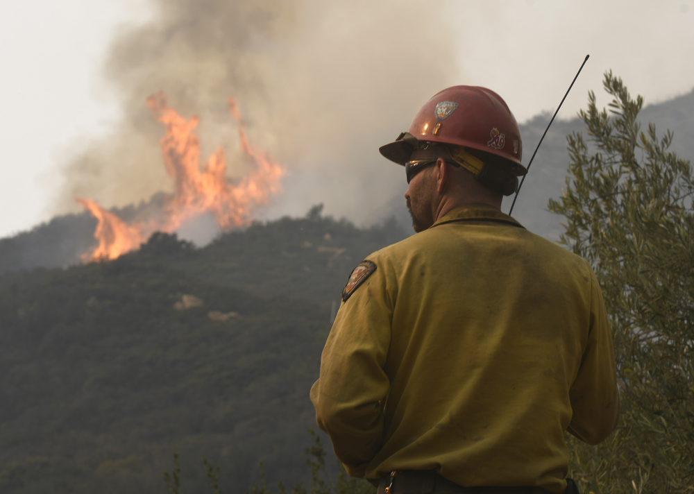
The Thomas Fire has been designated the top priority among all fires in the country. Accordingly, a massive army of firefighters has assembled: more than 8,000 personnel, 28 helicopters, six fixed-wing air tankers, a DC-10, and a 747 dropping millions of gallons of water and retardant. There are trucks, engines, and crew from just about every state and every county. It’s like a United Nations convention of firefighters. A small city of Oregon where it rains 250 inches a year sent its only engine, looking very much like a converted pickup truck with a hose attached. The Morongo Mission tribe sent a crew of hot shots. Ranks are designated by the color of headgear. Captains wear red, firefighters yellow, and chiefs white. The prison inmate crews — who clear the brush to create or expand defensible space before the fire hits — wear orange. Not surprisingly, they are known as “carrots.”
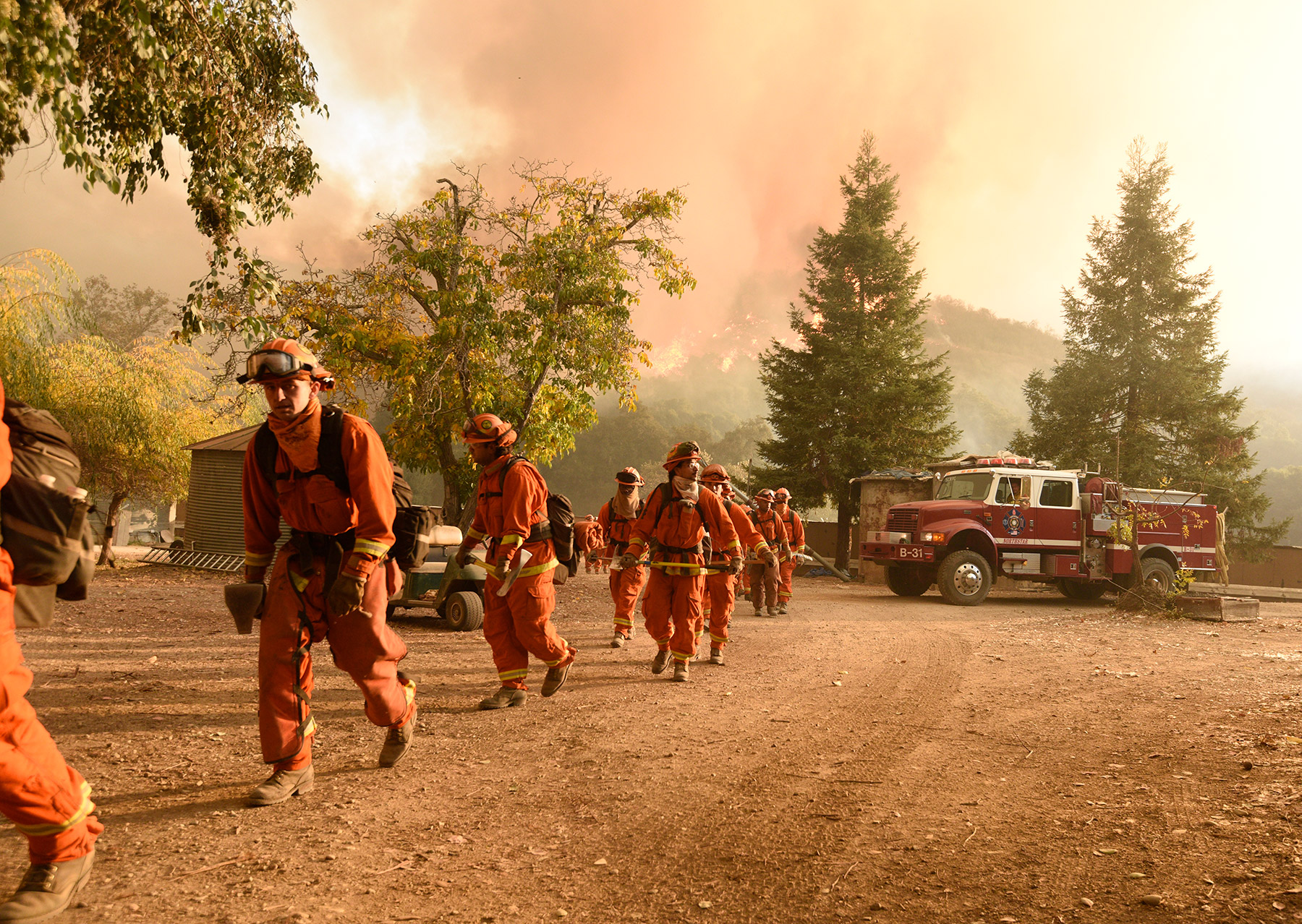
Climbing up the steep incline into Toro Canyon, crews from different regions worked in grimy common purpose, cutting lines through the brush with chain saws, perhaps the most important firefighting tool ever invented, followed by guys wielding axes told to “cut to black,” meaning cut through roots down to the burned earth. Other crews were laying hose where the soil was loose and slippery and the possibility of rocks rolling down on them was real. “If you see one coming, jump,” one firefighter said. “You’ll land on your ass and probably hurt yourself, but that’s better than having your knees taken out.”
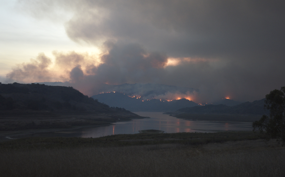
The incident command goals are twofold: to protect the South Coast’s watershed in Los Padres National Forest and to protect people and their property. Should the Los Padres be allowed to burn unmolested, the runoff of ash and dirt,loosened by the loss of vegetation, into the South Coast’s three main reservoirs — Juncal, Cachuma, and Gibraltar — could pose serious water-quality and supply problems. For Juncal and Gibraltar, it may already be too late. The plan is to push the Thomas Fire to the northwest, into the site of the 2007 Zaca Fire, where the fuel load is much lighter and easier to fight.
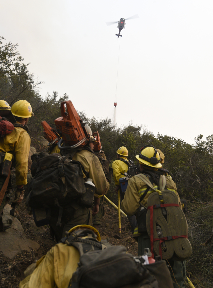
To protect human civilization and the urban interface, the plan is to hold the line at Toro Canyon if possible. But by Monday night, the fire had managed to escape, gobbling up some of the Romero Canyon watershed that runs parallel to Toro Canyon in a westerly direction. In response, air tankers, helicopters, and ground crews spent the better part of Tuesday attempting to pound that area into submission.
Since then, the incident commanders — a unified group of state, federal, and local fire chiefs who’ve been working fires together over the last 20 years — have devised a successive series of fallback positions to protect people and property and keep the fire from running down the front-country slopes. But the final line in the sand is Highway 154. In the days ahead, Highway 154 will increasingly become a long staging area. There’s an existing firebreak running from up on 154 at Windy Gap to Camino Cielo. The plan is to buttress and expand that.
To date, the largest fire in Santa Barbara County history is the Zaca Fire. It’s the fourth-biggest fire in recorded state history. It took the Zaca Fire two full months to burn 240,000 acres. It took the Thomas Fire only a week. The Zaca Fire cost $118 million. Incident commanders estimate it will cost more than $120 million to contain the Thomas, which they expect will happen sometime around Christmas.
Little wonder Governor Jerry Brown, a former Jesuit seminarian with an apocalyptic sense of environmental urgency, found the situation at the Ventura Fairgrounds headquarters of Incident Command on Saturday morning so alarming. At the time the Thomas Fire first erupted, Southern California was already battling five other infernos — from San Diego to Los Angeles. Most of them are now contained. But when you find 8,000 firefighters facing down a huge blaze days before Christmas, well, maybe he was right when he said, “This is the new normal.”

Santa Barbara has experienced record-shattering heat this year. And the year before that. And the year before that. For the past 250 days, we’ve had no appreciable precipitation. Translated, that’s 250 days without even one-tenth of an inch of rain. No rain is predicted in the next week. For the past eight days, the South Coast’s relative humidity has hovered in the single digits. On Tuesday, it dropped down to 1 percent.
Despite the seriously scary fires Santa Barbara has experienced in the last decade — the Gap, the Jesusita, the Tea — an astonishing amount of backcountry acreage has never burned in 50-90 years. After 20 years without a fire, the volume of dead vegetation in a forest exceeds that of live plants. Dead plants contain no moisture. It’s like someone planted millions of Molotov cocktails and the Thomas Fire is harvesting them.
In the meantime, the Thomas Fire has Santa Barbarans torn between terror and denial. People stop, stare at the red fire sun, and take selfies. The face mask, screening out the invisible particulates that inflict serious lung damage, has become ubiquitous, prompting people to stare hard into the eyes of passersby lest they pass a friend without saying hello. Do we know each other? Accustomed to surfing the surreal, Santa Barbarans adapt; the horrific — however exhausting and mesmerizing — becomes normalized.