UCSB Scientists Scour Montecito Creeks for Clues to the 1/9 Debris Flow
Dispatches from a Disaster: Part I
Tom Dunne has tramped all over the enormous debris flows, dozens of miles long, that were triggered in May 1980, during a volcanic eruption and avalanche on Mount St. Helens in Washington. But he has never seen anything like what happened in Montecito on January 9, when a catastrophic debris flow was triggered not by an eruption or landslide, but by a deluge that cut hundreds of thousands of narrow channels into the scorched mountain slopes.
How did that rainfall — a few intense bursts within a matter of minutes, beginning at 3:34 a.m. — generate enough mud to launch giant boulders down the narrow canyons, across the valley floor, and all the way to the beach?
“That’s the thing I’m trying to understand — the unfathomable intensity of the event,” said Dunne, a UCSB professor of geomorphology, or the science of the physical landscape. “In terms of damage to an urban area, I’ve only seen something like this in Japan, where you’re living on the side of active volcanoes.”
Dunne is part of a UCSB team that includes Ed Keller, a UCSB professor of earth sciences; Kristin Morell, an assistant professor of earth science; and Doug Jerolmack, a University of Pennsylvania professor of geophysics who was on sabbatical at UCSB when the debris flow occurred.
The team is studying the physics of the debris flow, the historical record of such flows in Montecito, and the rate of accumulation of the boulders in the canyons above the community. It’s an ambitious, long-range project; the scientists hope to advance the public’s understanding of what to expect after wildfires.
“I’ve never been close to something that happened so recently,” Jerolmack told an audience at UCSB’s Kavli Institute for Theoretical Physics in March. “The evidence is being erased day by day.
“We’re trying to do this forensic science of figuring out how big and how fast this flow was so that we can understand how it was made … We don’t have direct observations; it happened at night.”
In Montecito today, Jerolmack said, “It will be harder for something like this to happen again.” But, he cautioned, “There are some parts of these canyons where debris flows are just sitting there and never made it all the way down. So there are some boulders there, but not nearly as many as there were before.”
Keller and his students are mapping the boulders in the canyons above Montecito in order to measure the rate at which they pile up there — how rapidly the “gun” is loaded. It may take centuries for enough boulders to roll down the slopes and fill up these canyons, Keller said; no one really knows for sure.
Montecito and Santa Barbara were built on top of prehistoric debris flows, but scientists know the dates of only two of them; the flow at what is now Rocky Nook Park (1,000 years ago) and Mission Ridge (125,000 years ago). Much more work needs to be done before the overall frequency can be determined, Keller said.
In the short term, with little vegetation growing back in the burn scar of the Thomas Fire, the largest fire in California history, the Carpinteria Valley, Montecito, and many communities in Ventura County are at risk of a debris flow or a debris-laden flood in heavy rains next winter.
“To the east of us, there are many canyons that burned and did not receive anywhere near the same intensive rainfall,” Dunne said. “They could unleash debris flows if they experienced a squall line like the one here.”
‘Firehoses of Mud’
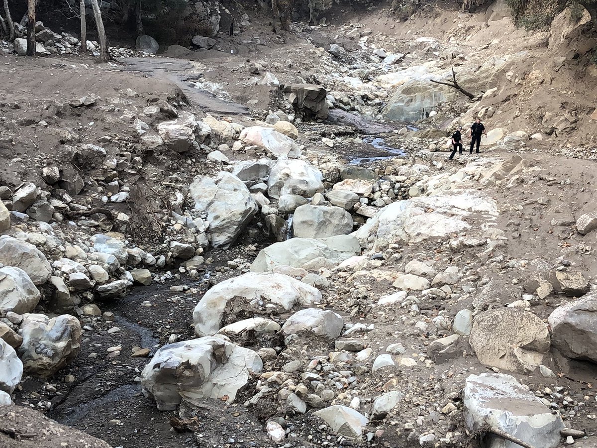
Twenty-three people were killed on January 9, and 470 structures were damaged or destroyed. It was several weeks before Dunne could get permission from the U.S. Forest Service to hike up into the charred canyons above Montecito. He wanted to see up close some of the hundreds of thousands of narrow channels, or rills, that the intense rainfall cut into the bare slopes on January 9. If he could measure them, he could estimate how much mud they generated.
The rills — between 4 and 12 inches deep and spaced half-an-inch to an inch apart — formed very quickly in the deluge, Dunne and Jerolmack believe.
“The hillside went from being barren to being dissected by thousands of these rills,” Jerolmack said. “The rainfall eroded them, and these rills became like firehoses of mud shooting straight into the channels.”
The resulting slurry of mud had the consistency of honey, scientists say; it buoyed up piles of boulders that were stacked in the canyons and propelled them downstream, also in a matter of minutes.
“It takes a lot of power to move a boulder down a creek,” Dunne said. “No one has yet been able to explain the mechanism that produced mud at such a rate in this kind of event. If I understood it, I could predict the kinds of rainstorms that would produce other debris flows. But I don’t know whether I’ll be successful.
“What we know from other debris flow events is that the mechanism of initiation is critical to determining all the other things — how big the peak flow rate was and how much warning time you have.”
There wasn’t much time on January 9. Based on anecdotal accounts, the flow reached the sleeping community of Montecito sometime between 3:40 and 3:47 a.m., with the boulders bobbing and knocking against each other up front — a deadly battering ram.
The boulders resisted the mudflow behind them and made it deeper, intensifying the hazard, Dunne said. The data, he said, will show whether significantly more of the flow would have been contained in the creek channels without this levee of boulders in front.
Among other seemingly impossible tasks, Dunne and his wife, Joan, are photographing a boulder from enough angles to assemble a 3-D picture of it. Then they will calculate the volume and weight of the boulder and figure out how much mud it would take to pick it up. They learned the technique from students.
“I think it’s fun,” Dunne said.
Dunne had only 24 hours in February to study the burned slopes before it rained again and the rills began to collapse. Now, he said, he is left to pore over high-resolution aerial photographs of the mountainside, taken shortly after January 9.
“That set me back weeks or months,” he said. “Things that we could have measured quickly in the field, we have to figure out a way to get from photographs.”
Mud ‘Super-Elevations’
In recent months, Dunne and his students have hiked Hot Springs, Cold Springs, Montecito, Oak, and San Ysidro creeks and their tributaries from East Camino Cielo to the ocean, lugging survey equipment to record the elevations of mudlines on trees and buildings — hundreds of them.
Amid the massive cleanup of Montecito, the evidence is fast disappearing. “I see all this data going away,” Dunne said.
A public request in April for photos, videos, and audio recordings of the flow yielded few results. So Dunne’s crew must piece together the data from the fragments that remain. They record the elevation of mudlines that haven’t yet been power-washed off of trees at the outside margins of the flow, where it was lowest and slowest, and nearer the main channel, where it ran deepest and fastest. The “super-elevations” — mudlines where the flow smacked into and ran up tree trunks as it surged downstream — will reveal the greatest velocities of the flow.
When the data is analyzed, the UCSB team will be able to describe the depth, volume, and velocity of the live debris flow as it raced down the canyons and across the valley floor. By contrast, the FEMA (Federal Emergency Management Agency) recovery map, due to be released on June 11, will show the topography of the mud deposits that were left behind.
Preliminary observations suggest that the flow was traveling fastest — about 27 miles per hour — in the upper reaches of San Ysidro Creek, Dunne said. (Anecdotally, residents report two surges on San Ysidro.) The deepest flow recorded to date — more than 20 feet deep — was at the Cold Springs trailhead on East Mountain Drive.
Dunne hopes to finish surveying the mudlines in the lower reaches of Buena Vista, Romero, and Toro creeks in the next few weeks. He and his students will survey Santa Monica and Carpinteria creeks in the Carpinteria Valley this summer.
In September, Dunne will travel to an observatory in Yunan, China, where scientists can watch a debris flow triggered by a landslide every afternoon during the monsoon season. For 40 years, the Chinese have been monitoring a large number of flows of different sizes here. Will they have any insights into how an ocean of mud came down on Montecito?
“I’m going to talk to Chinese scientists who are actively researching these processes, but I can’t tell you how I’m going to solve the problem,” Dunne said. “Science usually has to admit uncertainty.”
Tomorrow, in Dispatches: Part II, Dunne and survivors compare notes on the deadliest stretch of the 1/9 debris flow.
Dunne will give a presentation on the UCSB team’s research at the Karpeles Manuscript Library in Santa Barbara at 2 p.m. on July 21.