A Good Rain Finally Falls
Gibraltar Dam Spills, Cachuma on the Rise

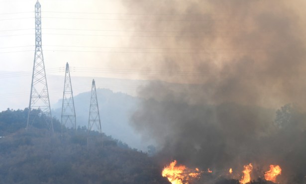
Nearly five inches were captured at Jameson Reservoir in the hills above Montecito from the rain that finally fell in torrents through the early hours on Thursday. The downpour triggered for the Carpinteria and Montecito areas first a watch alert at 2:14 a.m. and then a flood and debris flow warning at 4:50 a.m. from the Aware and Prepare early warning system. No road-blocking floods or mud flows were reported, Officer Maria Barriga with the California Highway Patrol said, though rocks and mud fell on streets in the mountain communities along State Route 154.
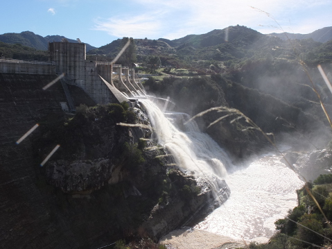
Gibraltar Reservoir, which collected more than five inches from the week’s rain, spilled near 9:30 a.m., Shawn Johnson with county hydrology reported. The spillover is running down the Santa Ynez River, headed for Lake Cachuma, which rose by noon by more than two feet to over 32 percent full. Runoff from the watersheds flowing to both reservoirs will continue to raise Cachuma’s water level for several days, said Johnson. Lake Cachuma Operations, which is run by the Interior Department’s Bureau of Reclamation, has not updated its inflow and outflow report since January 15.
Gibraltar’s overflow spun the stream gauge right below the dam to 8,130 cubic feet per second (CFS), or more than 60,000 gallons spewing from the dam per second. On the other side of the mountains, Mission Creek near the 101 was surging at 525 cfs at its peak at 7 a.m. Montecito Creek crested at 625 cfs at about the same time.
The debris basins in Montecito captured about 30,000 cubic yards of mud and rock, flowing down from the hills burned over by the Thomas Fire in December 2017, said county emergency director Robert Lewin, who spent the night with his team at the emergency management center. The basins will be cleared quickly, he said, at a cost of a half to a full million dollars.
The dry rain earlier in the week kept the ground from being overly saturated when last night’s storm arrived. “I can’t say I’m disappointed,” said Santa Barbara’s water manager Joshua Haggmark. “For many reasons I prefer the steady, gentle rain over the intense downpours that were predicted. Given the threat of debris flows, the latest rainfall has been a perfect balance of volume and intensity to avoid major damage.”
Eric Boldt with the National Weather Service called it a “curve ball.” Earlier in the week, “All models agreed on intensity and amounts, but we only received about half of what was indicated. Mainly the system split apart as it reached the coast. The low pressure center moved north toward Monterey while the rest of the system moved south of Pt. Conception. It had the potential to trigger strong thunderstorms, but this fell apart when the system split.”
Thursday’s rain system held together and had help from an “atmospheric river” moving in from the subtropics. Just as the early morning weather alert was pinging cell phones, about 1.2 inches per hour was landing in eastern San Luis Obispo County, as well as lightning strikes in SLO and western Santa Barbara County. It blew through and over to the San Gabriels, and the forecast is back to chilly and dry all next week. To date, the county’s rainfall is at 126 percent.
Editor’s Note: This article was updated on January 19 to track the information from Lake Cachuma Operations.