
New Evacuation Warning Issued for Alisal Fire
Update: Santa Barbara County Fire Reaches 9,000 Acres, Threatens Refineries
For the latest update, click here.
[Update: Oct. 12, 4 p.m.] Persistent winds continue to not only fan the Alisal Fire but cause fire brands to leapfrog across wide stretches of the hills and steep canyons of the Refugio area. By about 3 p.m., fire brands landing in Las Flores Canyon were starting fires, potentially threatening the Exxon refinery down the canyon. Specific information on the refinery’s fire plan were not available, but when viewed from satellite imaging, the facility appears to have a well-cleared area around it.
The fire estimate stands at 9,000 acres or more as of Tuesday afternoon. A wind shift cleared the smoke away from El Capitan, temporary home to the incident command center, but brisk winds are blowing steadily out of the north northwest again, gusting to about 30 mph in Refugio. The fire was making a run uphill near Mariposa Reina, the other refinery on the Gaviota Coast, Los Padres spokesperson Andrew Madsen said.
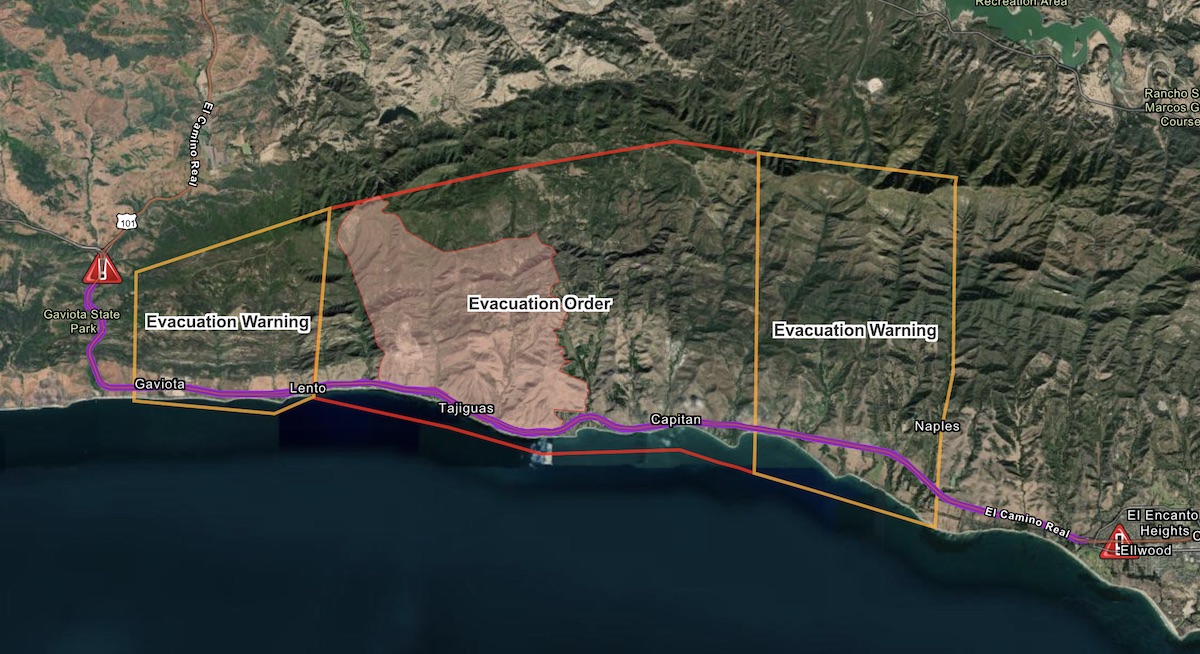
A new evacuation warning area was called around 3 p.m. for the area east of Calle Mariposa Reina, where the big Gaviota Oil & Gas Plant is located, and west of Arroyo Hondo Canyon up to West Camino Cielo Road.
Evacuation warnings for the area east of El Capitán State Beach Park, west of Dos Pueblos Canyon Road, and south of West Camino Cielo remain in effect, as do mandatory evacuation orders for anyone living in Arroyo Hondo Canyon, Refugio Canyon, and the area between El Capitán State Beach and West Camino Cielo. More info: ReadySBC.org.
The evacuation center at Dos Pueblos High School (7266 Alameda Ave., Goleta) remains open to evacuees, and the Earl Warren Showgrounds is open to anyone with animals in the affected area.
Highway 101 remains closed between Highway 1 near Lompoc and Winchester Canyon Road in Goleta.
[Update: Oct. 12, 3 p.m.] The Alisal Fire has reportedly jumped Refugio Road and is established in Venadito Canyon, where La Paloma Ranch lies in the upper foothills and the historic Orella Ranch closer toward the highway. Venadito is to the east of Refugio, which puts the active fire line about a mile and a half from El Capitán.
As firefighters burned pockets of dry grass along the northbound 101 near Arroyo Hondo, which lies below the origin of the fire yesterday, the Board of Supervisors declared the Alisal Fire a local emergency. The supervisors’ resolution stated approximately 270 residents were ordered evacuated and another 260 were under evacuation warning, while at least 100 structures were threatened, not only homes, ranches, and the state campground at Refugio but also Tajiguas Landfill and the railroad tracks and service. The decision paves the way for the governor to declare an emergency in the county and the concomitant emergency funds that could follow.
[Update: Oct. 12, 1:30 p.m.] With wind conditions still too frisky — both aloft and on the surface — no fixed-wing firefighting aircraft have yet been deployed on the Alisal Fire, which has grown now to about 7,000 acres in size. Four to five helicopters have been deployed, however. Highway 101 remains closed, Caltans confirmed.
If and when the winds die down, as predicted earlier in the day, air tankers can be made available from bases in Paso Robles and Porterville. That’s according to Captain Daniel Bertucelli, public information officer for the County Fire Department. Bertucelli would not hazard an estimate as to how many planes can and will be made available at that time other than to say “several.” He added that the Santa Maria Airport includes a facility where firefighting aircraft can both refuel and replenish their load of fire retardant.
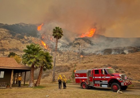
In the meantime, Bertucelli said, about 700 firefighters are deployed, creating lines around the fire. “They’re doing good work, important work,” he said. “It’s just not as visible as an air tanker flying across the horizon.”
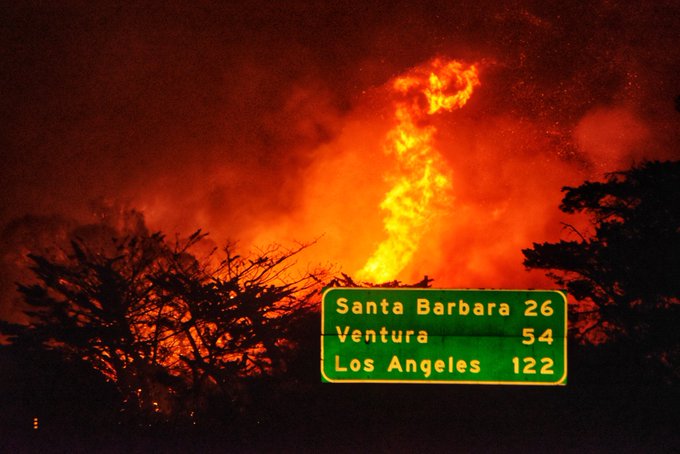
The Alisal Fire, he said, is heading to the east; translated into plainer English, that means it’s moving in the general direction of Goleta, roughly 10 miles away. Right now, the fire is about 3.5 miles to the west — up the coast — from El Capitán State Beach and about 24 miles from downtown Santa Barbara, where the smoke can be seen and smelled. (The Santa Barbara County Public Health Department and Air Pollution Control District have issued an Air Quality Watch due to smoke and ash caused by the Alisal Fire.) Depending on who you talk to, it either has just recently jumped to the east side of Refugio Canyon or is about to do so.
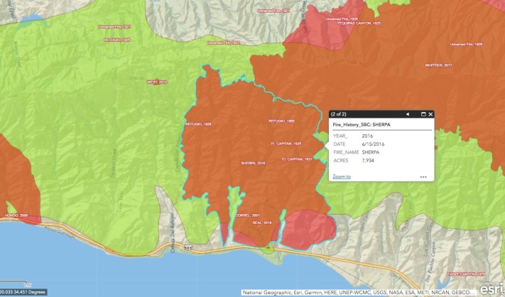
Either way, the good news is that the Alisal Fire will now encroach onto the terrain of the Sherpa Fire, which five years ago burned up 7,000 acres of coastal shrubland. Much of the Sherpa terrain has since revegetated, but not nearly as thickly and densely as the terrain Alisal Fire most recently traversed. Most of this area had not burned since 1955. With less fuel, the hope is the Alisal’s rate of spread will slow down significantly. “That will really help us with this,” Bertucelli said.
[Update: Oct. 12, 11:00 a.m.] Helicopters are now in Refugio Canyon, hitting flareups occurring on the east-side ridge of the canyon. The Alisal Fire crossed Refugio Creek from east to west, said Eric Hvolboll on the Alegria Ranch, and was headed into heavy brush along Refugio Road south of the Circle Bar B Ranch. The ‘copters are using the Alegria’s reservoir to load their buckets, Hvolboll said.
Winds diminished from gusts of 35 mph to about 27 currently, blowing steadily out of the northwest at 14 mph, allowing the helicopters to fly in blowy conditions.
[Update: Oct. 12, 10:00 a.m.] The Alisal Fire burned its way down the south-facing mountainsides last night from Lake Alisal — located on the other side of the ridge line — all the way down to the coast by Refugio and Tajiguas canyons, where it made a run at the county’s new multimillion-dollar recycling plant located at the Tajiguas Landfill. “We have an active fire on both sides of Highway 101,” County Fire Chief Mark Hartwig told the county supervisors at a special briefing this morning. “It made a run at the landfill last night. We made a stand.” Only minimal damage was sustained, he said, but no homes in the nearby canyons were damaged as far as he knew. “We have structure protection in place on Refugio Road there,” Hartwig said.
Hartwig apologized for not having better news to report. The winds remain sufficiently erratic, he said, that it’s not safe to deploy firefighting aircraft. He said he expects the conditions to shift later this morning. When that happens, he said, the projection is that we’ll get an “onshore flow” that will chase the fire up the canyons in daylight hours and then reverse course — as is customary for such winds — back downslope after the sun sets.
It was not clear how many planes are currently at the Alisal Fire’s disposal and how many are on call, but Hartwig said he’s attempting to get his hands on as many as possible to beat back a fire that’s already burned about 6,000 acres and is currently projected to burn up to 7,500.

Hartwig estimated about 600 firefighters have been deployed so far. To date, he added, only minimal damage was done to a chipper left in a field near the county’s ReSource Center, or materials recovery facility (MRF), located at Tajiguas Landfill. The ReSource Center is part of a vast $150 million project recently completed at the landfill to convert as much of the organic material deposited at the landfill into methane or compost while maximizing the quantity of recyclable materials extracted and sold on the global recycling market. Hartwig noted that the piping through which methane gas is fed may have sustained damage from the fire. Likewise, he said, the fire got close enough to threaten a new wood-chipping component of the expanded landfill operations. “We have resources on it as we speak,” he said.
Kelly Hubbard, director of the county’s Office of Emergency Management, stated that 18 individuals spent the night at the county’s evacuation center located at Dos Pueblos High School. Of those, she said 14 were Amtrak train passengers whose journey yesterday was cut short by the fire. Another four were residents of the area.
Hubbard repeated that mandatory evacuation orders are still in place, that the freeway — between Highway 1 near Lompoc and Winchester Canyon in Goleta — is still off-limits, and that evacuation warnings should be heeded. For those wondering whether they are affected by either, she directed them to the website ReadySBC.org.
[Original Story] Although the winds have subsided from the violent gusts that raked the county yesterday, the Alisal Fire has continued to expand during the night and is now estimated at 6,000 acres. When the fire was first reported early yesterday afternoon, it was estimated at 100 acres. Roughly 600 firefighting personnel are on the scene, County Fire spokesperson Mike Eliason reported, and if the winds allow, firefighting planes will get airborne and be deployed in the containment battle.

In the meantime, Highway 101 remains closed off to traffic in both north and south directions between Highway 1 and Winchester Canyon Road/Cathedral Oaks, and at Highway 1 outside Lompoc.
Mandatory evacuation orders — that’s “orders,” not warnings — remain in effect as well for anyone living in Arroyo Hondo Canyon, Refugio Canyon, and the area between El Capitán State Beach and West Camino Cielo. Reportedly as many as 150 homes are potentially threatened. To date, one outbuilding has been destroyed and one truck jackknifed on the freeway.
Evacuation warnings have been issued for the area east of El Capitán State Beach Park, west of Dos Pueblos Canyon Road and south of West Camino Cielo. Emergency-response planners are urging residents to be prepared to bolt upon a moment’s notice.
In the meantime, the Earl Warren Showgrounds have been opened up to anyone with animals in the affected area.
The 101 remained closed both for public safety — the fire and smoke were making visibility very poor at times — and to allow fire engines and dozer crews to come and go quickly, said Jim Shivers, spokesperson for Caltrans. Any reopening depended on fire conditions, he said.
The 154 through the San Marcos Pass is open and remains the alternate route for travel between Santa Barbara and the Santa Ynez Valley. It was congested just east of Lake Cachuma this morning, said Shivers, and dozens of cars waited in line at the 101 intersection this morning. “A big dose of patience is needed today,” Shivers said.
For the longer haul and larger trucks, Interstate 5 remained the best option for travel through Central California. To reach the coast from the 5, Shivers suggested highway 46 East was a faster and safer route than the twisting narrows of Highway 166 near Santa Maria. The 46 leaves the 5 in the Lost Hills area and heads toward Paso Robles.
Find all our updates on the Alisal Fire here.
Correction: The “Chevron refinery” referred to in an earlier version of this story is now the Gaviota Oil & Gas Plant operated by Freeport McMoRan Oil & Gas.
Credit: Mike Eliason/S.B. County Fire Dept. 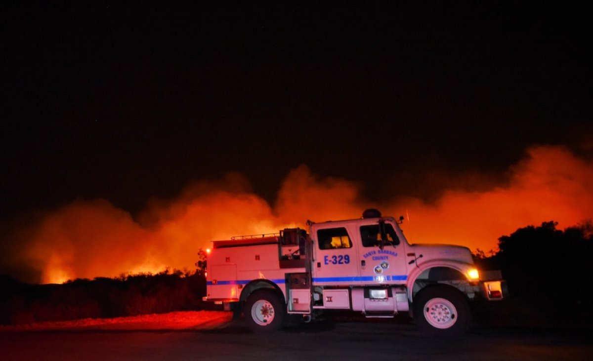
Credit: Mike Eliason/S.B. County Fire Dept. 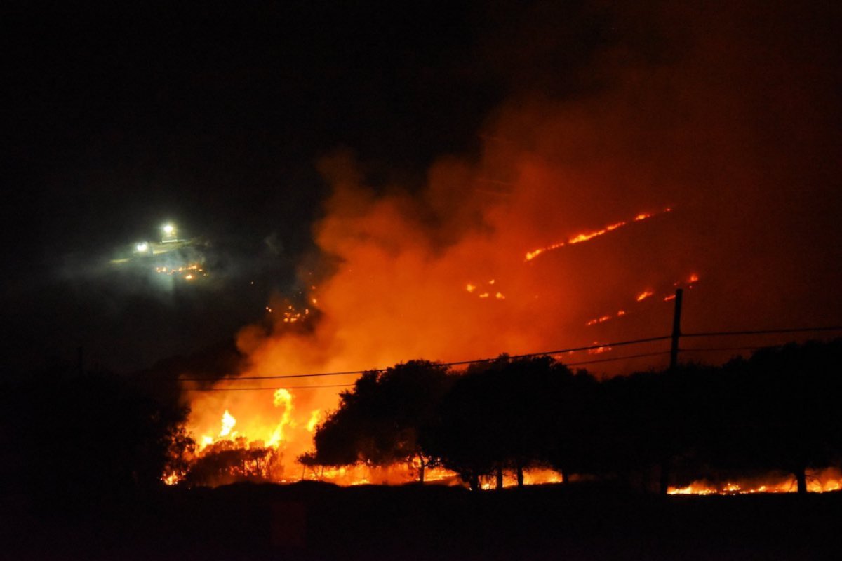
Credit: Mike Eliason/S.B. County Fire Dept. 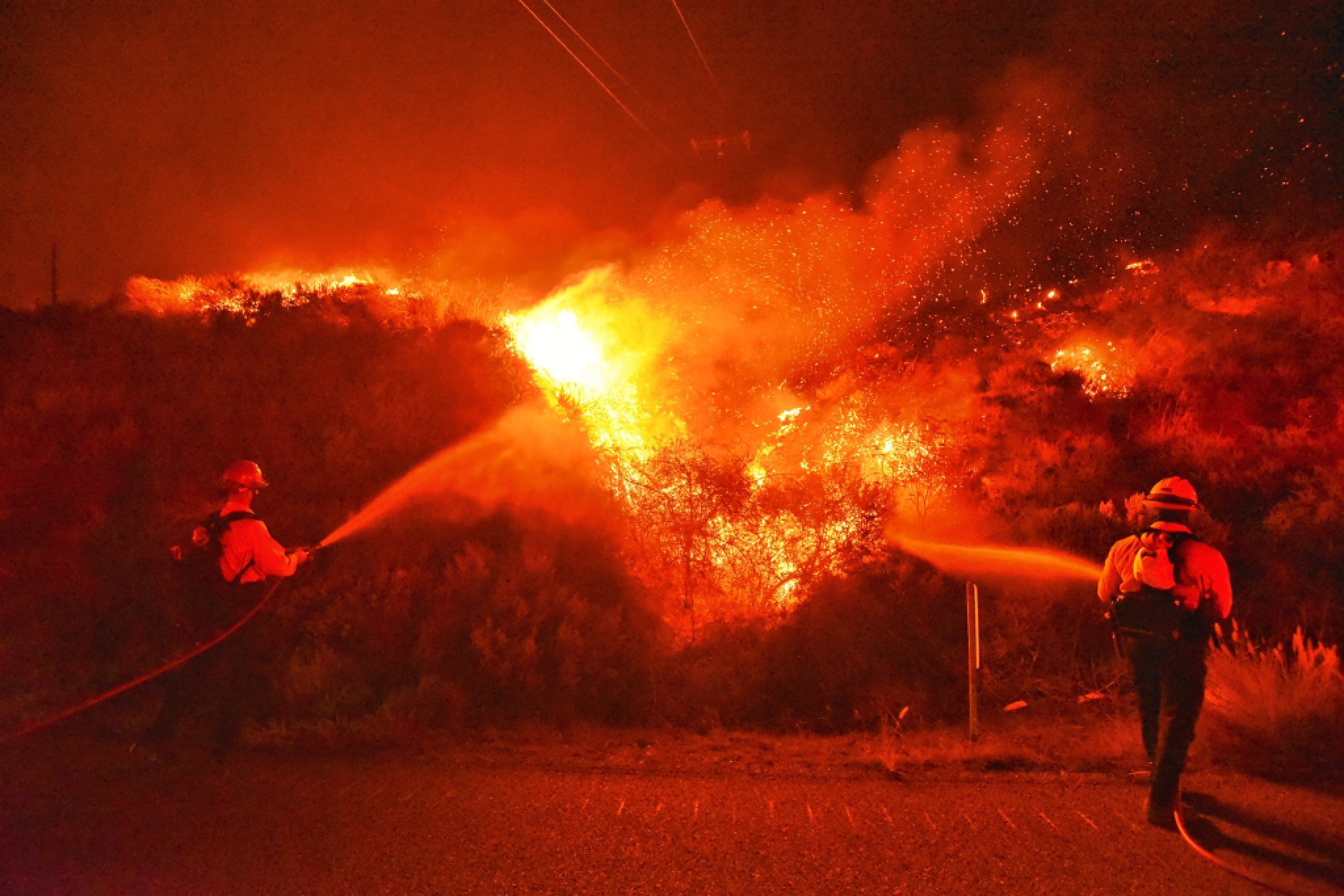
Credit: Mike Eliason/S.B. County Fire Dept. 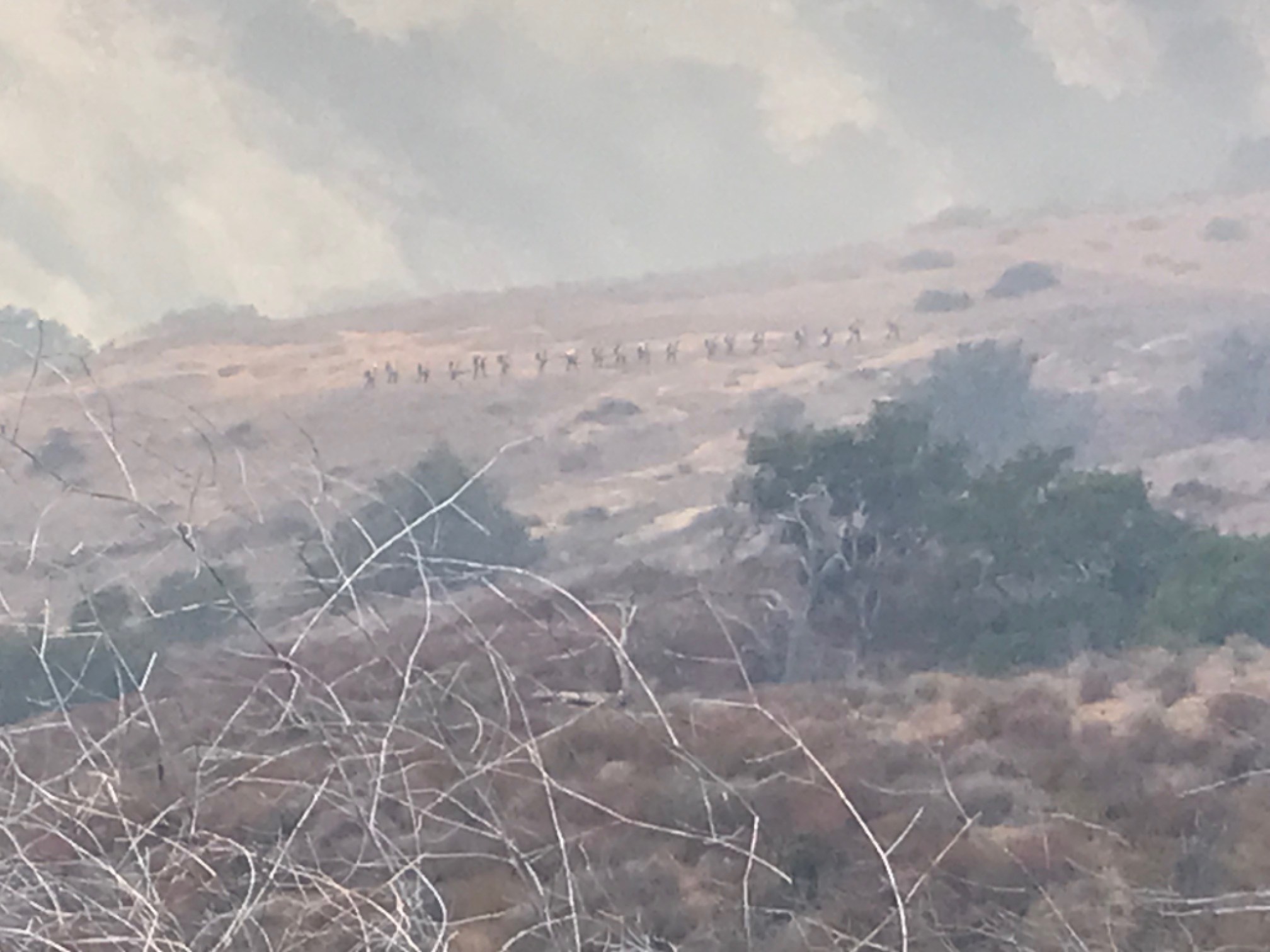
A hand crew treks up Refugio Canyon during the Alisal Fire. | Credit: Eric Hvolboll 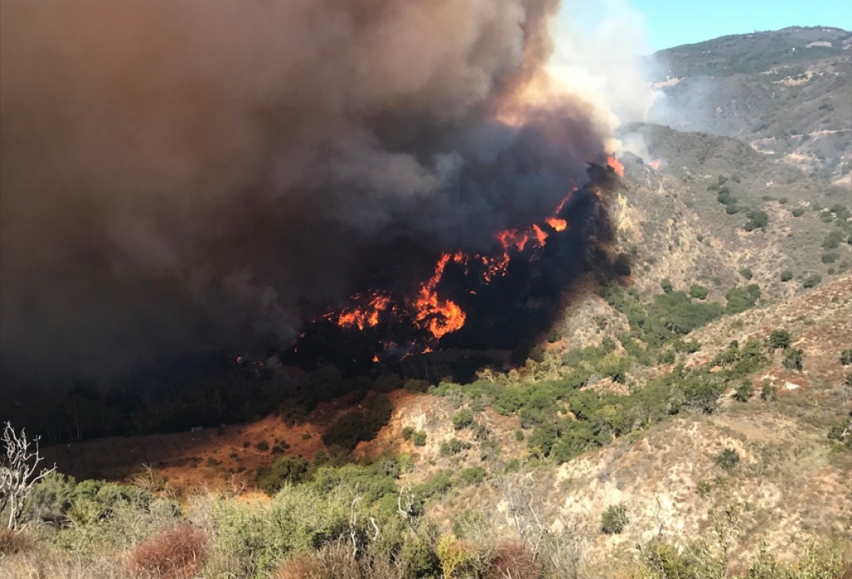
The Alisal Fire pushes down into Refugio Canyon Tuesday morning, driven by gusty winds. | Credit: Eric Hvolboll 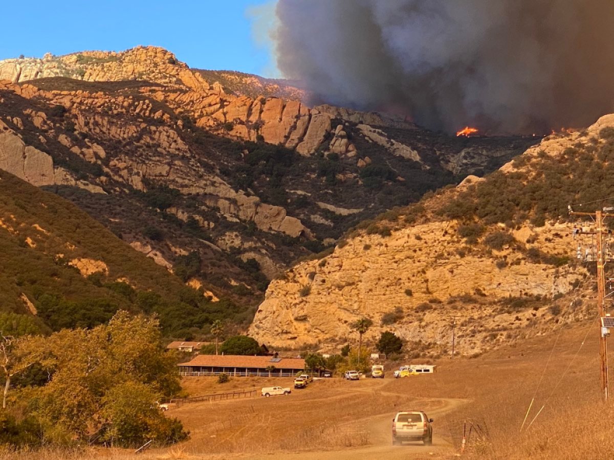
The Alisal Fire burns near a ranch off Highway 101 on Tuesday afternoon. | Credit: Mike Eliason/S.B. County Fire
Support the Santa Barbara Independent through a long-term or a single contribution.


You must be logged in to post a comment.