‘Twin Perch’ Trail Frontside Loop
Bushwacking Sideways in the Frontcountry
Hike: Steep day hike and scramble up from Rattlesnake Canyon Trail to Tunnel Trail, and return back down Tunnel Connector Trail to Rattlesnake Canyon Trail. Suitable for fit children ages 11 and above.
Mileage: Six-mile roundtrip with steep scrambling and off-trail bushwhacking.
Time: Eight minutes driving to Skofield Park, and about four hours hiking, including a half-hour rest and snack at the “Twin Perch” peaks.
Maps: Ray Ford’sHiker’s Guide to the Santa Barbara Frontcountry map (square 2C to 3C) is readable, although he delineates no trail between Rattlesnake Canyon Trail and his “Mission Crags” (my “twin perch”); Craig Carey’sHiking and Backpacking Santa Barbara and Ventura has this on map 6.
Commingling difficult coastal mountain “scrambles” with easier day hikes and more strenuous backpacks has been necessary to keep my outdoor life constantly interesting. The variety these scrambles offer creates more and more mental stimulation, refreshes different body joints, rejuvenates the imagination, restocks memory, and obliges the simple climber/hiker to indulge needed solitude. None of these scrambles, like the one described here to “Twin Perch” (Ray Ford’s “Mission Crags”), involve technical climbing, so anyone strong and willing can undertake them. (In earlier columns I described scrambles to La Cumbre Peak and to “Rocky Ridge.”)
During this six-mile hike to Twin Perch we begin at Skofield Park, walk north up into the beautiful, steep Rattlesnake Canyon Wilderness Area trail, and after a half-mile or so leave the main trail on a well-gouged spur trail heading northwest (to the left). You will pinpoint this trail shortly after skirting the fragrant pine meadow just above the second creek crossing. An ill-advised 1970s-era Sierra Club plan to stabilize this loose hillside with Japanese black pine and other nonnative conifers has at least managed to hold this slump together for 40 years, but most of the trees are slowly dying.
This narrow footpath is quite obvious and has been recently cleared by trail volunteers, so you simply head upward on it toward the 2,500-foot ridgeline topped out by my fancifully named Twin Perch formation. The trail is well-trodden, and if you choose to go up on the weekend after 9 a.m., there will be several other hikers on the trail, including their ubiquitous and frequently excreting dogs.
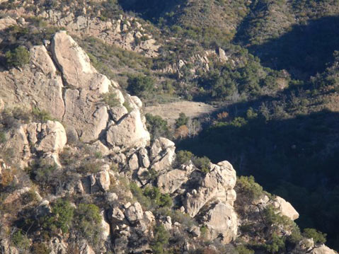
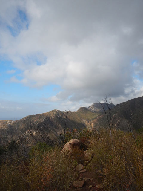
Thus, I recommend you start very early, by 7 a.m. at least. Higher up, you will have to scramble among large sandstone boulders, so you will need to wear heavy boots, gloves, long pants, sturdy long-sleeved shirt, wide-brimmed hat, sunglasses, and carry two liters of water in bottles on your fanny pack. As you ascend through thick, hard chaparral, now brushed-over from the 2009 Jesusita Fire, you catch glimpses of Tin Shack Meadow at the junction of Rattlesnake Canyon Trail and the Tunnel Connector Trail below.
My hiking colleague Chris and I like this unnamed trail because after you reach the ugly Edison maintenance road (go right a few hundred yards on it) and ascend higher, you also catch lovely views of that same 0.67-mile-long Tunnel Connector. While on the Edison dirt road you pass two of the giant power towers, but at the one numbered 22 you cut off the road, find the very faint trail, and begin bushwhacking upward in earnest. This is a sort of trail, although it’s unmarked on both the Ford and Carey maps, so we now call this bushwhacking or just going cross-country. Another benefit of this arduous clamber, besides getting into better shape, is that there are absolutely no people around. If the wild is the refuge of the unconscious, and you seek some interior secrets there, the sudden presence of other homo sapiens does not help. For this reason, Chris and I generally hike several hundred yards apart (and I’m older and slower).
Naturalist Barry Lopez attempts to explain the allure of getting into true wilderness and temporarily away from other humans as he praises John Fowles’s 1979 essay The Tree:
We live at a time in which it is hard to find an unmanipulated landscape … it’s difficult to locate ‘nature without an audience’.
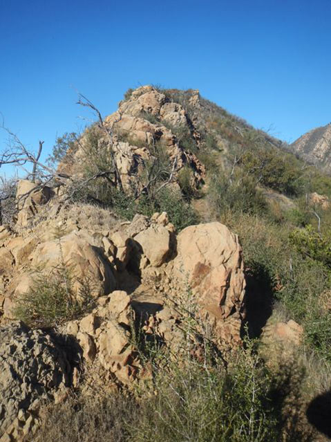
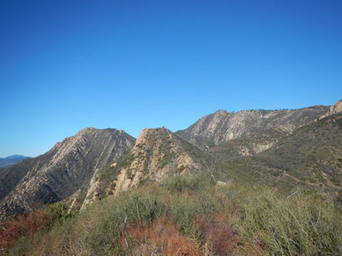
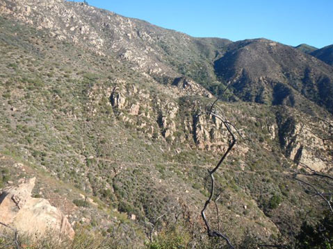
Another hour of heavy toil, clambering over or around the huge pink boulders mixed with the fire-hardened manzanita bush spikes, and a little over two hours in, we haul ourselves up onto the second perch, the one further from the vast sea we observe below. While barely three miles, it is a most rigorous climb, and I’ve had a few cuts and slips, but nothing bad. We can see the emerald green of Santa Barbara town, the harbor, Santa Cruz and Santa Rosa islands, and a few wispy clouds hovering about Santa Cruz’s Mt. Diablo. The sudden freedom of view is uplifting and also utterly amazing. The spectacular vista west from the second perch, shown in the center of the lead photograph above, boasts Arlington Peak on the left and then 3,900-foot La Cumbre Peak on the right; behind us we would see barren Mission Falls and Angostura Pass.
Chris and I speak little, and in fact we each occupy our own perch; pardon the rampant anthropomorphism. We’ve discovered nature without an audience, but unlike Freud with Anna O., we do remember we are ourselves the hidden audience in this awesome mountain- and seascape. We haven’t found an “unmanipulated landscape” since we used the nasty Edison maintenance road for a short space, and we cannot avoid being witness to the dozen or so gigantic power towers carrying the juice to civilization below.
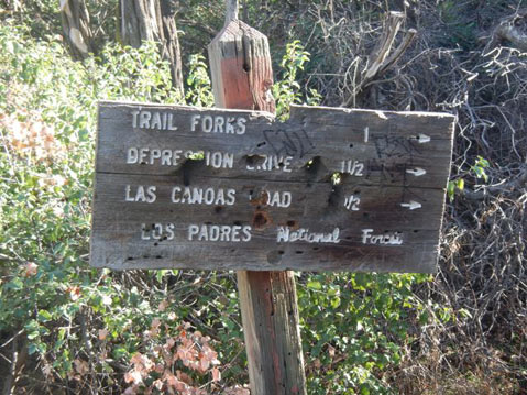
We finish the loop by continuing on a few hundred brutal yards dropping down a difficult descent to Tunnel Trail, then turn right away from the sea and after a few hundred additional yards on this excellent path encounter the wooden trail sign with “TRAIL FORKS” on the top. Take the right on the previously seen Tunnel Connector, and go down toward “Depression Drive.” At Tin Shack Meadow head on down through the riparian splendor of Rattlesnake Canyon to your car at Las Canoas Road or Skofield Park.
Santa Barbara’s low frontside coastal mountains beckon to us not least for the glorious variety of interesting hikes. After 42 years roaming around in our frontcountry and backcountry, it’s grand fun to devise yet another day-hike combination. Try this Twin Perch (“Mission Crags”) strenuous scramble–cum–day hike sometime!