
Kennedy Ridge or Bust

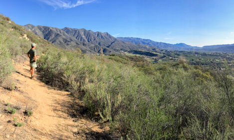

As you ascend the switchbacks leading to the top of Kennedy Ridge the whole Ojai Valley comes into view. The Topatopa Mountain escarpment provides a similar backdrop to what we in Santa Barbara consider so special and the views out to the Pacific Ocean add a distant charm to a very enjoyable mountain hike.
On the Trail
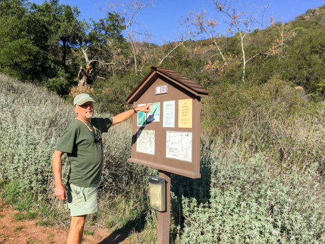
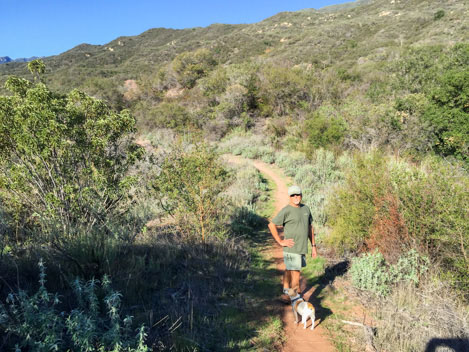
We’ve been hiking a bit over a half hour when we reached the Kiosk marking the start of the Kennedy Ridge Trail. My hiking partner for the day is Rick Bisaccia, the Stewardship Director for the Ojai Valley Land Conservancy (OVLC). “Now for the tough part,” Rick tells me. “The route up to the top of the ridge isn’t as good a trail as we wanted to make but the views will blow your socks off.”
Rick is a jack-of-all trades kind of guy, overseeing the various properties owned by the Conservancy, such as the Ventura River Preserve, where we are hiking today. The Preserve has over 17 miles of trails that allow extended hikes up and down the river as well as across and up a number of beautiful oak canyons. The Preserve is open to hikers, mountain bikers and equestrians alike, with dogs required to be on leash.
To this point the hiking has been easy. From the Oso parking lot the trail cuts down and across the Ventura River — dry most of the time — and then follows a short part of the Orange Grove Trail before turning right on the Rice Canyon Trail to a point where the trail crosses a private road. The turns are a bit tricky getting to the point where the Kennedy Ridge Trail takes off but thanks to Rick, each of the trailheads is stocked with free color maps that will keep you on track.
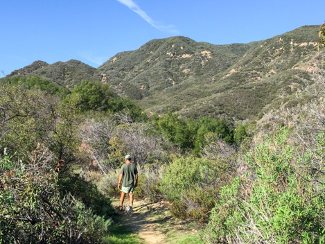
Though it is still mid-winter, it’s a warm day in Ojai. The sky is clear and the wind perfectly still. Rick is in the lead with his dog, Betty, who is not far behind furiously pumping her small legs to keep up with us. We contour the side of a small drainage covered with oaks, the grade beginning to get a bit steeper, enough to warm up our legs without breaking a sweat.
Just as the canyon begins to open up we connect with a jeep road, take a left turn and follow it several hundred yards to the Kiosk where Rick gives me an overview of the Kennedy Ridge Trail and what the Conservancy needed to accomplish to get it built and open to the public. “Quite a few years ago the Conservancy acquired this section of the Preserve,” he says as he points to the map. “This was a really important acquisition because it pushed our land to the Forest boundary and made it possible to think about connecting a route up to Kennedy Ridge.”
Climbing the Ridge
In the weird ways that property boundaries often are, it turns out the northern boundary of the newly acquired parcel is just about halfway up the ridge, meaning that getting the trail built would require Forest Service permission. Fortunately, the Ojai District Ranger at the time, John Bridgewater, was sympathetic to the idea of connecting up to the ridge and eventually he provided support for the project.
As we begin to climb higher up the knoll leading to the top of the ridge, the views begin to pop up; west along the base of Kennedy Ridge towards White Ledge Peak, northeast to the Topatopa Mountains and in the far distance the Pacific Ocean. Though steep, the climb isn’t too difficult, and between breaths there is plenty of time to inhale the rich smell of the chaparral, the sound of the birds hidden in the bushes and the new vistas around every turn.
At one point Rick stops me and says, “This is just about the point we step off OVLC property and head into the Forest.” It really is in the middle of the hill. “We might have done a better job of building the trail if we had full clearance to do it right,” Bisaccia adds. “But John was concerned that if the trail were ever to be abandoned that he wanted to make it as minimal as possible.” That included shorter steeper switchbacks and leaving the cut burls in place so they might crown sprout later and if necessary make it easier for the corridor to recover.
The hike up to the top of the ridge takes about 40 minutes, with enough time for Rick to fill me in on the chaparral plants, the geology and to point out a number of different places in the valley. Then he shouts, “Look up there!” He’s pointing to a sandstone outcropping that marks the top of the ridge. “There’s a red-tail hawk perching up there.” Just as we get to level ground the hawk takes off, screeching its annoyance, I’m sure, at our interrupting its morning stop.
The views are magnificent. Rick shoos me off to the right and around a large ceanothus bush to a spot where there is a picnic table perfectly situated for a lunch over the valley. Turning to the north from the table the view straight up the river valley through Wheeler Gorge, with Pine Mountain in the far distance is plenty enough to ensure I’ll be up here again many more times.
West on the Ridge
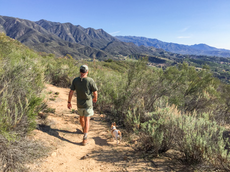
From the top of the knoll, the Kennedy Ridge Trail turns sharply left and heads almost due west. The ridge is broad enough to provide a generous corridor that allows the trail to meander here and there but with a sharp enough dropoff so the chaparral rarely obstructs one’s views on either side. Perfect.
The ridge walk itself is a mile long and one of the most enjoyable sections of trail you’ll ever experience. Though ascending gradually from an elevation of 1,474’ at the picnic table to 1,760’ at the end, it is actually more of a yo-yo type walk, with gradual uphills, gentle downhills and a few steeper ups and downs to get the heart pumping. At places the trail winds through 10-foot-tall ceanothus, Manzanita, toyon and other of the mountain plants, sometimes in shade and others in the sun — but with the panoramic views never much further away than the next turn.
At one point we spot a mountain biker grinding his way towards us up one of the small hills along the way. It’s a tough climb on bike up the switchbacks to the ridge but apparently he’s got the skill and energy to do it. He stops and gives us a big grin when he reaches us. “Man, that was tough,” he exclaims. Then he is off, cruising down the far side of the hill and on the end of the ridge. It turns out he drives a UPS truck and the ride is his version of a lunch break. A fun one at that I think as he disappears over the next knoll.

At the one mile mark along the ridge the trail more or less comes to an end, though a rough section of overgrown trail does continue west for a quarter mile to the next saddle, definitely not something worth exploring but for those of us who like to explore, intriguing nevertheless.
What is more intriguing is the connector trail that heads off to the north, dipping for a bit then climbing steeply up to East Camino Cielo, an abandoned section of jeepway, that some of us would like to see re-opened all the way to Divide Peak. But that story is for another day. At this point we’ve hiked just over 2.6 miles, meaning that the round trip is 5.2 miles, give or take a few yards, plenty for the day — at least for me.
Perhaps next trip I’ll get a much earlier start and explore a bit of Camino Cielo as well.
4•1•1
For more detailed information about the Kennedy Ridge Trail including links to additional information, photo galleries, maps, KML downloads and lots more, check out the trail blog on the Santa Barbara Outdoors (SBO) website. Created by long-time outdoor expert and Indy Outdoor Editor Ray Ford, SBO is the place to go for information about where to hike, bike, ride or walk in Santa Barbara County.


