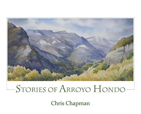
‘Stories of Arroyo Hondo’
Chris Chapman Illustrates the Soul of the Gaviota Coast

A highlight of driving west on the highway past Ellwood is the view of the shoreline’s angular sandstone ribs, the youthful uplift of ancient sediments that line up parallel to the coast. This dramatic geomorphology crests at Santa Ynez Peak above El Capitan. Below, grasslands cover the nearby Rincon shale, and ceanothus chaparral encases steeper Vaqueros sandstone slopes above.
The rocks, like the highway, trend west. Both are regularly interrupted by canyons running south, slowly eroding the mountains into the Pacific. One of the deepest and most picturesque is the Arroyo Hondo, between Refugio and Gaviota.
In her brilliantly illustrated new book, Stories of Arroyo Hondo, author (and well-known area artist) Chris Chapman dissects the canyon’s human stratigraphy. In explicating its historic layers, she presents an archetype of our region’s history, starting more than 5,000 years ago with Chumash antecedents and their historic village of Tuxmu.
Santa Barbara’s first colonial family, the Ortegas, settled nearby at Refugio in 1794. In 1842, fourth-generation Ortegas, brothers Pedro and Manuel, built an adobe house at Arroyo Hondo where the original coast road crosses the perennial, fish-filled creek. Silverio Konoyo, born on Santa Rosa Island in 1788, lived at Arroyo Hondo and helped build the adobe. Konoyo was a proud maker and master of plank canoes, a Chumash survivor of Spanish colonization.
The Ortega family owned the Arroyo Hondo until 1908, when Jennie Hollister Hale purchased it. Like the canyon’s former anachronism, Konoyo, Pedro Ortega’s grandson Vicente continued living at the Arroyo Hondo through the late 1970s as ranch manager for Jennie’s branch of the Hollister family. An iconic vaquero, Vicente Ortega was born at Arroyo Hondo in 1885 and worked with Chumash vaquero Fernando Librado as well as for Jennie’s brother, Jim Hollister, on the neighboring Gaviota Ranch. In 2001, Jennie’s family sold the Arroyo Hondo to the Land Trust for Santa Barbara for a land preserve.
The historic photographs are of great interest — they include the canyon’s prominent Ortega and Hollister residents as well as its classic Mexican period adobe house. The photos, some previously unpublished, are complemented by 32 plein air paintings by Chapman and her talented husband, John Iwerks. Many illustrate the canyon’s native flora.
One of the most interesting sections is devoted to the Arroyo Hondo’s role in transportation. These layers illustrate California history: Konoyo’s plank canoes; the first land exploration route by Spanish explorers later known as “El Camino Real”; the County’s Coast Highway and 1910 bridge; the canyon’s stagecoach stop/café from 1863-1900; the 1898 railroad trestle; the stunning 529-foot concrete two-lane highway bridge built in 1918 with five beautiful parabolic arches surmounted by 44 smaller arches; and the tragic all-but-ruination of the mouth of the canyon in 1949 by the state highway department’s earth fill for a four-lane highway. In 2007, the Land Trust installed a steelhead-friendly baffle system in the concrete culvert under the highway to enhance fish migration in the creek.