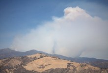
Zaca Fire Continues Its Eastward Spread

From the observation area along Highway 154 the views are dramatic. Though it is difficult to see what is happening on the far ridge near Mission Pine Basin, in the middle distances you can see the tendrils of flame slowly working their way down the steep south face of Black Canyon. Though it appears the fire is not far from the Santa Ynez Valley, topography and fuel loading favor the fire fighters should the fire continue directly south towards the Santa Ynez River.

Camping Wars

UCSB’s higher-ups ban all on-campus camping, block means of student protest.

Reefer Madness

Barney talks to a well-known Goleta physician, gets the dirt on the Coral Casino delay, and examines the race for 3rd District Supervisor.

Zaca Fire Moves Into Santa Cruz Drainage

At mid-morning, as the heat began to build, flames could be seen working their way both south and east along the front flanks of San Rafael Mountain and McKinley Peak. For a while it appeared the fire line would spill down into Peachtree Canyon. A little after noon, as the upper part of the West Fork of Santa Cruz Creek became engulfed in flames, the plume burst through the sky like a hot air balloon, sending smoke thousands of feet into the air.

Your Worship

The Buddhist Church of Santa Barbara has been one of Santa Barbara’s best kept spiritual and cultural secrets for nearly 80 years.

Zaca Fire Update

Afternoon winds carrying smoke from the Zaca Fire prompted a flood of calls to fire headquarters. As the sun set and blood-red moon crested the Santa Ynez Mountains, for the first time since the fire started, flames can be seen from the valley floor.

Sunday morning has an Evacuation Warning issued for Happy Canyon Road up to Baseline Avenue, and an Evacuation Order for the Peachtree Community.

Login

Please note this login is to submit events or press releases. Use this page here to login for your Independent subscription

Not a member? Sign up here.