

‘Welcome to Isla Vista‘ is a six-part podcast series. Listen to new episodes here or anywhere you get your podcasts.
This is Welcome to Isla Vista.
I’m Christina McDermott. I cover housing for the Santa Barbara Independent. As a housing reporter, I write a lot about Isla Vista. There is, simply, a lot to write about, from overcrowding to rental inspections to new developments all within an area where cyclists zip from class to home, live bands play out of their living rooms, and community gardens grow food.
I.V. is this hodge-podge of lecture notes and red solo cups, living on top of one another and living together, for thousands of UC Santa Barbara and Santa Barbara City College students.
It’s more than that too: It’s renting families and a few longtime homeowners and other tenants living among and guiding students.
I.V. makes me wonder — how did it get this way? That’s what this podcast is about, and that’s the answer I’m still chasing. But, I want to share with you what I’ve learned and some of the perspectives I’ve learned from.
So welcome to Del Playa Drive.
Daniel Fouchy lives on ‘oceanside Del Playa’. Oceanside, because the house he shares with nine other guys is only a few yards from the cliff’s edge. You can stand on his back patio and see the Pacific sweep out before you, with Platform Holly glinting in the distance.
“Sunsets out here — it’s hard to get much better than this,” he told me.
Fouchy is a fourth-year student at UCSB. He said he pays more than $1,600 a month to share a small bedroom on the first floor. The bedroom window faces a fence, not the ocean. The house itself is nice enough — no visible mold or vermin, which isn’t always a guarantee in I.V. — but he said the kitchen’s dishwasher was broken when they moved in, and it took his landlord three months to fix it.
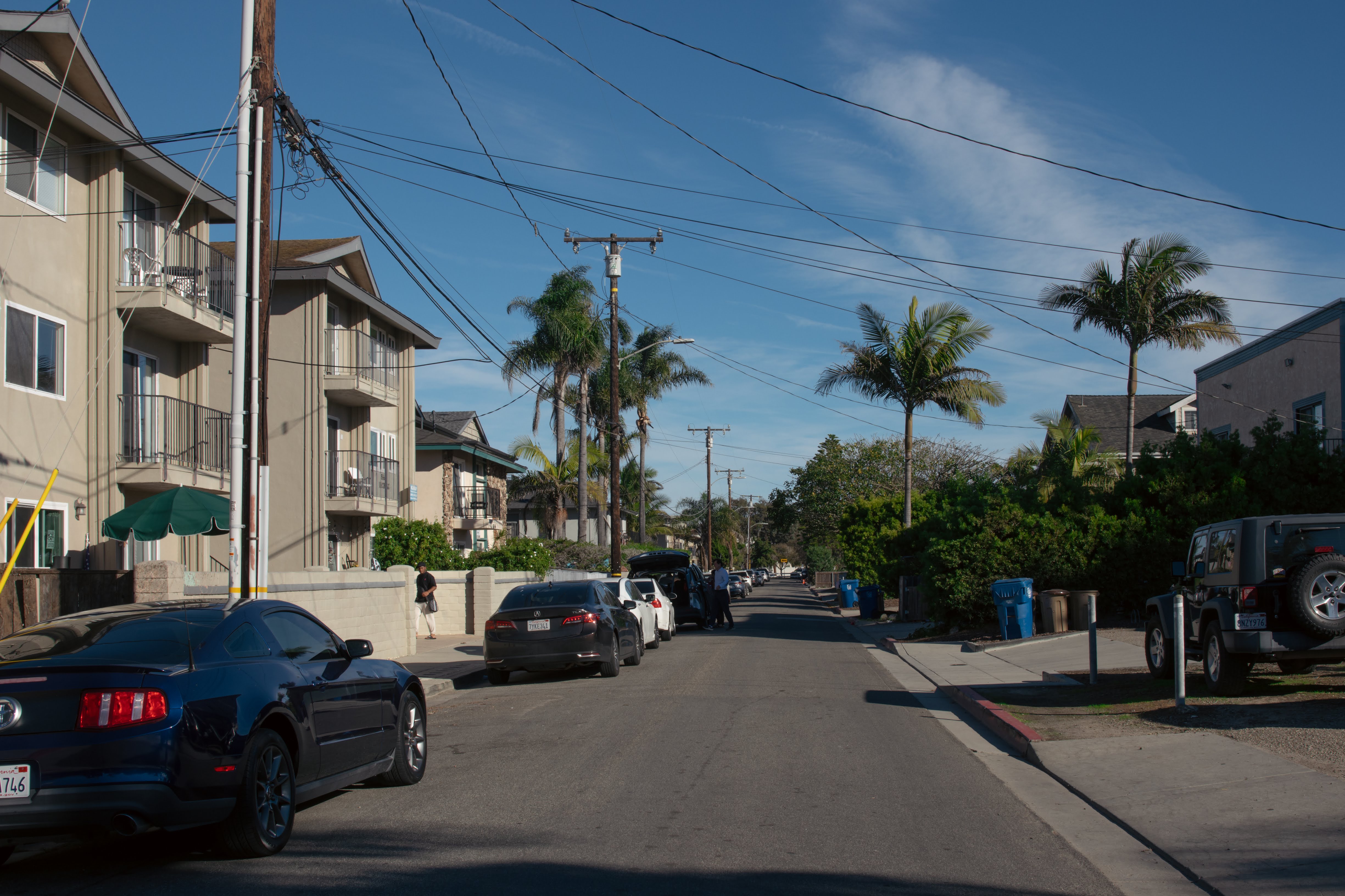
Del Playa Drive is one of the oldest roads in Isla Vista. It’s also one of the most famous, crowded, and expensive. Quads, or four people sharing a room, aren’t uncommon. Balconies creep over the bluffside. On the street, parking is tight, with cars often lining red curbs. Driveways configurations look like Tetris.
“I didn’t realize just how claustrophobic and just how small I.V. is for so many people, and how that would kind of make it into what it is,” he said. “I was imagining something a lot more laid back and kind of quieter, because I thought it was on the beach.”
Isla Vista is not your typical beach town. More than 13,000 people live here in a little over half a square mile through the school year, crammed into apartment buildings and houses, illegally converted garages, and retrofitted vehicles.
The vast majority of Isla Vistans rent. Most of them are students, attending UCSB or Santa Barbara City College, but thousands of non-students, including many families.
Its housing stock is aging even as rent prices increase. The situation is bad enough that Santa Barbara County implemented a preliminary rental inspection program last year. The program is an attempt to try to get landlords to fix what the county considered unsafe conditions. The starting place? Del Playa.
On oceanside DP, the lots themselves are ever shrinking as the bluffs erode. There used to be enough space between the edge of the houses and the bluffs for a bike path in the ’80s. But over the past twenty five years, dozens of landlords have sliced off part of their developments and moved them away from the cliff.

Isla Vista wasn’t always dense housing. In fact, fewer than 400 people lived here 75 years ago. How it operates now is because of its development. Isla Vista works how it was designed to.
To understand how it got this way, we need to go back in time.
Lisa Stratton is the Director of Ecosystem Management at the UCSB’s Cheadle Center for Biodiversity and Ecological Restoration.
One day in July, Stratton and I hiked just east of I.V., on university land in front of Manzanita Village, a dorm complex.
Stratton has spent decades working to restore the area’s native wetlands. It’s just a few minutes walk from Del Playa, but rather than clustered houses, pavement, and crowds, vernal pools sit tucked in swaying purple needle grass. A path winds through the restored area, connecting to the university’s lagoon and Campus Point.
This area was once wetland and oak forest. For thousands of years, Chumash peoples lived along the Goleta Slough in dense, rich communities.
Despite centuries of colonization and systematic attempts to dismantle and destroy their culture, Chumash people are still here. They are better equipped to tell their stories than a podcast on housing in I.V., but I do want to acknowledge that this area was not empty space before Spanish contact. And I want to give you some names of places in the area.
The mesa UCSB is located on, was once called, based on linguistic and anthropological research, Anisq’oyo, which may have meant “at the Manzanita.” Nearby, where the Santa Barbara Airport is, was the Island of Quwa’ and the large town Helo’. In the 1940s, the U.S. military used Quwa,which the Spanish called Mescaltitlan, to fill in much of the slough to build the airport, disrupting graves and historic sites. A fenced-in grassy mound remains there.
In the 19th century, resource extraction became a big thing. As late as the mid-1800s, oak trees still grew in this area. But in the late 1800s, many oaks in the area were cut down to sell to whaling fleets.
“1850 to 1870 was a massive whaling era, and Goleta Beach was a big whaling port,” Stratton said.
Whalers burned the wood to heat whale blubber, allowing them to extract the precious whale oil. In the 19th century, whale oil was used for a lot of things, including lighting lamps and making soap.
A planning document written about 100 years after this timber enterprise gives us a hint of its impact on I.V.’s land. In 1973, the UC Board of Regents funded an architect named John Robert Henderson to write a “preliminary planning report” on Isla Vista. That report included a history.
“So many trees were felled that many were left to rot, unsold. As a consequence, the topsoil was lost, and Isla Vista was soon only left with blowsand,” the report said.
On our walk, Stratton told me there was still evidence of old oaks on campus, near the Rec Center.
“[They] are probably on the order of 500 years old or older. They’re really big, old, stately oaks,” Stratton said.
In the time since our interview, she said, one of those two trees has fallen over.
From the late 1800s on, there was the water problem in I.V., too — there wasn’t much, if any, fresh water in the area.

Isla Vista was not, then, fertile ground for growing crops, like other parts of Goleta. Still, there were opportunities to make money with resources below the surface. In the late 1800s, an asphaltum mine operated on what’s now UCSB’s campus. It took advantage of a core that ran through the Goleta coast.
The asphaltum mine shut down around the turn of the century, after the resource grew more scarce. But with the success of oil drilling up and down the coast, and the mine’s former productivity, people didn’t give up on what was below the ground.
Picture 1925, Santa Barbara area. An earthquake topples major buildings downtown. Goleta is full of lemon orchards. Tar seeps up from beaches up and down the coast. And across the country, ordinary people are racking up debt by buying things on credit.
In 1925 and 1926, three investor groups bought the parcels of land that make up Isla Vista. The center parcel was the largest. It was called (I bet you can guess) Isla Vista. The groups had a plan: subdivide and sell the land like shares for oil ventures. On maps, they created roads and lots to sell piece by piece.
“[People] were just hoping to get lucky,” said Dr. Jennifer Strand, a historian who, while earning her PhD at UCSB in the ’80s and ’90s, studied Isla Vista. Hers is one of a few comprehensive modern histories of the place.
“You could buy one plot and then just drill down there, if you wanted to. You could buy 10. You would probably have a better chance of finding any oil that was down there if you had 10,” she said.

The developers mapped out all these streets, and they gave them names. If you’ve ever wondered why it’s “Del Playa” and not “De la Playa,” or why it’s “Isla Vista” and not “Vista de Isla,” Strand has an answer for you. It’s unlikely that those investors who named them spoke Spanish.
These three tracks are also the reason that I.V.’s roads aren’t a perfect grid. Not everything connects, because it wasn’t all planned together.
But it is those plans that created the basis for the community. Those narrow lots that line Del Playa Drive were never for student housing. They were kind of part of an oil scheme.
Folks didn’t strike it rich with huge oil reserves in I.V. And without fresh water, it was hard to develop.
“And if they had found a lot of oil right underneath Isla Vista, it wouldn’t be a subdivision today. People probably wouldn’t live there. But they didn’t find a lot,” Strand said.
In the ’30s, Strand estimates, there were probably fewer than 50 people who lived in I.V. — mostly, she writes in her master’s thesis, people who couldn’t afford much else.
Sometimes, though, things change suddenly.
In December of 1941, more than 2,400 miles away, the Japanese military bombed a U.S. base. The attack on Pearl Harbor launched the United States into World War II. Development of a U.S. Marine base in Goleta kicked into gear. Shelling by a Japanese submarine just a few miles north at Ellwood’s oil field may have helped add to a sense of urgency.

Less than a decade later, after years of efforts, Santa Barbara’s T.M. Storke, alongside other prominent, politically powerful people like philanthropist Pearl Chase, would convince the UC Board of Regents to open a new university in Goleta.
I could create a whole series on Storke and his push to open a UC in S.B. but for time’s sake, I will summarize. Storke (yes, UCSB’s tower and the road to Costco are named after him) was connected. He had friends all throughout politics, was involved in politics, and was the longtime publisher of the biggest newspaper in the Santa Barbara area at that time, the News-Press.
Storke convinced the Marines to sell the base for $1 in 1948. And he managed to help bolster the necessary support to get people to vote for Cachuma Dam, which would deliver the critical water source needed for the university and for I.V.
Soon, the whole area would belong to the UC Board of Regents. All except a little rectangle — Isla Vista, which, because it had been sold piecemeal for oil ventures, had, Strand writes, upward of 500 owners, considering both surface and subsurface rights.
Suddenly, Isla Vista, dry and empty as it was at the time, became very valuable.
“You look at Isla Vista and it just is strategically located right next to the University,” said Dr. Jennifer Strand. “The university is going to need housing because every university, you know, from the beginning of time, needs some housing.
An entirely new type of community — one fed by college students — was about to take shape.
I’m Christina McDermott and this is Welcome to Isla Vista.
That was Episode 1 of Welcome to Isla Vista. Next week, tune in to Episode 2, where we’re delving into student stories, from 1954 all the way up to 2016 and the rise and fall of IV’s building boom. Get ready for zoning variances, memories of live music, and cockroaches.
Episode 1 was written, fact-checked, recorded and produced by Christina McDermott, the Mickey Flacks Fellow for the Santa Barbara Independent. Episode 1’s script was edited by the independent’s news editor, Jackson Friedman. The historical clip from John Robert Henderson was voiced by Dylan Charney. The Pearl Harbor radio clip was used with permission from RadioTapes.com. And the song in this episode is Clam by The Framers. You can find the Framer’s music on Spotify here and you can follow them on Instagram @theframers_sb.

You must be logged in to post a comment.