
Exploring Aotearoa, Māori
for The Land of the
Long White Cloud
We Explore the South and North Islands of
Aotearea/New Zealand on Land and by Sea,
in the Wake of Cyclone Gabrielle
By Mary Heebner | Photos by Macduff Everton
May 2, 2023

Land of the Long White Cloud
Imagine the vast dark sea as a place, and that the map to understanding this place lives in the heavens. Imagine learning the intricate language of the stars, when and where they rise and set, how they rotate in the circular celestial diagrams that are the foundation of wayfaring, the learned and memorized skills of celestial navigation.
Although both modern and traditional navigators take into account weather patterns, the movement of the currents and tides as well as avian and marine life, celestial mapping in traditional wayfaring guided these travelers accurately before GPS or satellites. It is an ancient art that has survived across the Pacific and Melanesia through elders such as Mau “Papa” Piailug (Satawal), Sir Hector “Hek” Busby (New Zealand), and Nainoa Thompson, (Hawaii), and is still being taught and practiced today.
The area triangulated by Rapa Nui (Easter Island), Hawai’i, and New Zealand is home to distinct but interrelated Pacific cultures living on and across more than a thousand islands. Aotearoa, or “The Land of the Long White Cloud” as it translates in Māori language, is the indigenous name used for both the North Island, and for the country as a whole, the largest island complex in this Pacific triangle.
Māori cosmology tells the history of this land as a story not only of wayfaring but of fishing. Te Wai Ponamu, as New Zealand’s South Island is known, figures in this story as the waka or canoe of Maui, the primordial Polynesian demigod, while Rakiura or Stewart Island is the anchor, and the angular, jutting North Island is a massive, hooked fish that Maui succeeds in pulling out of the vast Pacific. During the month we travel through New Zealand, it seems as if this large fish is lunging, leaping, and diving, as the inhabitants once again, rock and roll with it.

Auckland
Our first stop is Auckland, where, triennially, our daughter Sienna teaches anthropology to 20 students from her home institution, Dartmouth College, via an exchange program with the University of Auckland. We hope to explore Auckland in our week with Sienna, before boarding the National Geographic Orion, for a coastal expedition beginning in the South Island. When we arrive, Sienna reports that Cyclone Gabrielle is forming and will likely close the airport in the coming days. Auckland is already reeling and recovering from a massive rain event that saw more than ten inches of precipitation fall on the city in only 15 hours, causing floods, landslides, loss of life, power outages, and the watery inundation and closure of Auckland’s international airport. We catch the earliest available flight out before the airport closes and fly to Queenstown on the South Island, which is awash in sunshine.

On Land: Walks and Wineries Near Queenstown
Although known to some as the bungee jumping capital of the world, we are more interested in sampling the wines from the surrounding Otago Valley vineyards, in particular Chard Farm Winery in the Gibbston Valley overlooking the Kawarau River. In the deep river gorge below the winery, white water rafters drift with the current, and bungee jumpers hoot with delight as they launch from the Kawarau Bridge and then kiss the water, if they’re crazy enough. Light-spangled pencil thin plane trees cast striped shadows across the dirt road leading to the winery. The Chard family had farmed this land since the 1800s. In 1989, new owners saw the potential in the soil and location to plant a vineyard. and retained the name of this historic farm for their winery. We taste a sampling of delicious whites and pinot noir and buy a bottle of their reserve pinot noir.


The glacially carved Wakatipu basin hills seem like bony shoulders draped in aeneas summery robes. We drive to Wanaka then follow a dirt road to Mt. Aspiring National Park, fording nine shallow creek crossings that in winter make this road inaccessible. The Rob Roy Glacier Track takes us through meadows with grazing sheep, leading to a swing bridge over the west branch of the Mātukituki River, where we hike uphill on a narrow, rocky, fern-lined trail through a beech forest. As I carefully pick my way up the hill, a couple of avid runners whiz by me. Fast or slow, the reward at the top is a stunning view of the hanging glacier.
The following day, we choose the more leisurely Glenorchy Walkway, a raised metal platform cut through the riparian area of willow, juncus, berries, and birdsong, that limns a lagoon. Thirty-some black swans surprise us. They feed, preen, court and nest here, so the obvious comes to mind, this is Swan Lake! Only later I looked up the name for a gathering of swans — you guessed it, it’s either a bank or a ballet of swans. They coo and trumpet, bend their long, graceful necks, and flex their 6-foot wingspan before flying low across the water. Native to Tasmania and Australia the black swans seem to enjoy life on this lagoon in Glenorchy.
By Sea: On to the Fjords
And then we’re off! All it takes is a 6-hour long bus ride with other guests and staff to Milford Sound, and we are ferried out to our ship. In the half-light the silhouettes of tree ferns soar as tall as palm trees. A welcoming committee of dolphins swims by the ship at sunset as we sail to nearby Poison Cove for the night. After a restful night’s sleep, I wake to a fisherman’s basket moon in a dark cloudless sky, opening to a hazy rosy first light.

The day begins with a splash when, doubling back to Milford Sound, staff members motor us — eight guests to a Zodiac — right up to a streaming, roaring waterfall. My face and rain jacket are soaked, a baptism of ice-cold heaven. I look wide-eyed straight up at the waterfall. It falls some 180 feet down to the fjord, and beneath us, the water is some 180 feet deep. So, in effect our Zodiac is midpoint between the top of the waterfall and the bottom of the fjord.
One of the advantages of a Lindblad/National Geographic expedition cruise is reaching places larger ships cannot. In Fiordland National Park, we enter Dusky Sound to explore the finger-like fjords. A fjord is steep-sided, narrow underwater valley carved by U or V-shaped glaciers ages ago. These ancient valleys then flooded with seawater, creating the fjords we explored this morning. It is a sheer landscape replete with water, but with so little soil for nutrients, that the flax, ferns, gnarled trees, and mosses cling with a mighty, slow-growing grip onto the rock face. It is chunky with life.

New Zealand writes the book on the color green. Thickets of fern, epiphytes, beech, flax, and dinosaurian trees sprouting broccoli-like florets hover above a matrix of moss-sleeved branches — little birds quicken the bush, unseen but heard, a cacophony of tweets and trills.

Nephrite — called New Zealand jade or greenstone or in Māori, pounamu — exists in rich geological deposits found only in the South Island. It was and is treasured by the Māori whose very name for the South Island is te wai pounamu, the waters of Pounamu. They endow this durable stone with healing and spiritual power, use it for crafting ornaments, tools, and weaponry. When I hold a delicately carved jade pounamu spiral up to the light it is as luminous as a newly unfurled leaf.
Dusky Sound leads us toward Resolution Island, which is abundant with marine and bird life. The flooding of a river valley forms a sound, its contours have a more gradual incline than valleys carved by glaciers. In Zodiacs we explore the coastline, all greens and shadows. Shiny black eyes peer at us from a sheltered rock, perky ear flaps bracket their tiny, whiskered faces, and when they catch the sound of our approach, the baby fur seals whelp in surprise. The sleek velvet pups cavort in water so clear I feel I could reach in and touch the bottom. These protected inlets, nooks, and coves are havens within the crenulated coastline that better ensure the pups survive their first precarious year. A nursery of shallow pools, ample food, where no shark or killer whale gains entry.
Predator-Free Conservation: A Fantastic Buzz of Life
Back in 1891 the New Zealand government declared Resolution Island a nature reserve. Caretaker and naturalist Richard Henry physically rowed over 200 kakapos, a flightless 2-foot-tall nocturnal parrot that can live up to 120 years, to Resolution Island in hopes to bring back this nearly extinct bird, once hunted for its meat and feathers. Despite Henry’s efforts, the birds were wiped out in a mere six years by stoats, non-native animals that, ironically, were introduced from Britain in the 1880s to eliminate feral rabbits. The struggle is ongoing. New Zealand’s endemism is the highest in the world, a place where native birds evolved as flightless, in a land virtually free of mammals. Sustained conservation efforts are necessary to create and maintain predator proof offshore islands.

To the south, across Foveaux Strait, we explore Stewart Island, called Raikiura in Māori, which references the “glowing skies,” of aurora australis. This small island is the above-mentioned mythical anchor holding the South Island in place. Rakiura National Park, created in 2002, covers 85 percent of the island. The first Polynesian wayfarers and migrants who arrived in the South Island and Rakiura 800 years ago encountered heavily forested islands, where they hunted the abundant 12 foot tall, flightless Moa birds to extinction in less than 100 years. Tastes like chicken and just one can feed a village! Their feathers and skin were made into clothing, and bones used for fish hooks, tools, and ornament. The moa’s main predator, other than humans, was the massive-clawed Haast eagle that lived from the Pleistocene, 2 million years ago, dying out about 600 years ago as their favorite food source dwindled.
Today Rakiura is at the heart of a conservation movement to eliminate introduced predators such as stoats, pigs, rodents, and to re-populate nearly lost species of winged and flightless birds. From a small dock on Ulva Island in the Patterson Inlet, in Rakiura National Park, Rosy, a local naturalist, leads us on a forest path pointing out some species that existed 100 million years ago — ancient trees like the Rimu valued for its copper hued timber, that can live for 1000 years, and the large-trunked Totara, with flaky bark like golden sheets of parchment paper, highly valued by canoe builders. Through years of effort, and vigilance, they have eradicated all introduced predators on this jewel of an island, including the most difficult pest, rattus exulans, the rat.
Owner of a similarly remote group of islands, the Shiants in the Outer Hebrides, Adam Nicholson, influenced by New Zealand’s efforts, oversaw a rat eradication program. As quoted in Islander, A Journey Around our Archipelago by Patrick Barkham, he comments, “The thing you get when you go to an island whose rats have been destroyed, it’s not just the seabirds — everything feels more alive. There’s an incredible sense of wellbeing. These little birds, wrens and wheatears and warblers, a fantastic buzz of life. It’s an unequivocally good thing. I wake up at 3 a.m. and think, thank God for that. It’s amazing.”
Birds thrive. We are keen to spot the plump Kereru-wood pigeon, Kakariki parakeet, the sonorous bellbird, the high-pitched pihihi, and the inquisitive Stewart Island robin, the flightless weka, and the fantail, flitting from tree to bush like a fan dancer. We even spy the minuscule, ancient rifleman elusive among the branches of a tree overlooking the beach. But I catch no sight of the iconic bird of New Zealand, relative to the moa, the kiwi. It is nocturnal, leaving little trace of its ramblings in the light of day.
At Sea: Thar, She Blows!
Our itinerary includes whale watching off Kaikoura. I have seen many species of whale but never a sperm whale and just as I delight in the birds on Ulva Island, I hope to witness the world’s largest toothed predator, Physeter Macrocephalus, whose amphibious predecessors are found in the fossil record 70 million years ago. Its nearest ancestor, that roamed the seas 13 million years ago, was, in 2010, named Levithan (L.melvillei), after Herman Melville’s sea monster of old. Think Moby Dick. Old Testament. Jonah and the Whale. With a block shaped head occupying one third of its entire body, with the largest brain on earth, the sperm whale is basically sightless — who needs eyes in the dark depths of the sea — sound is its guide. Its head is filled with oily spermaceti that scientists believe serve as a ballast and when diving deep, aid in buoyancy when surfacing, as well as echolocation.
These weighty creatures have adapted to dive 2,500 feet routinely but are capable of hunting at depths of 10,000 feet for over 60 minutes. They make the long journey back up to the surface, every 45-60 minutes and, after a few moments of rest, last breaths, and exhalations, a fluke of its tail signals its descent to roam and hunt again.
Sperm whales handily grapple with great white and megamouth shark, grouper, giant squid, and other cephalopods. Their long strong teeth make for fearsome weapons. Whalers developed the art of scrimshaw, whiling away their time at sea etching designs into the collected ivories of harpooned sperm whales.

Creatures like this come from an age of giants — gargantuan, carnivorous, predatory. Like the fearsome Haast eagle, doomed by the disappearance of its prey, what do the oceans hold in today’s warming climate, diminishing habitat, and rising seas, to feed these Titans of yesteryear? Sperm whales need to eat around 3 percent of their body weight a day. A full grown 50-foot male weighing 45 tons feeds on one hell of a lot of sashimi.
Once heavily hunted for their oil, the duel used to heat, light, and also to make soap. They were also hunted for a valued waste product from these creatures’ squid-based diet, a waxy substance found in the digestive system called ambergris. It is the musky, exotic scent in perfumes, also valued for its medicinal properties, and once priced at twice that of gold. Chemists developed a synthetic version of ambergris, yet merchants still risk pursuing costly, desired lumps of this mysterious substance. Gestation itself is tied to being hunted. Females give birth every 4-20 years, a wide range of birth rate that rises and falls dependent upon whaling activity. More threat to survival, more calves. Females and young travel in matriarchal pods, and calves remain in their mother’s care for at least a dozen years. At birth the 12-14-foot-long calf weighs about 2,000 pounds. Except for mating, the much larger bulls form bachelor herds apart from the others.
We board a Māori-owned and -operated large catamaran, taking seats inside. As the captain puts pedal to the metal for the 40-minute raucous motor ride out to deep sea, a crew member delivers a blessing in Māori and then shares information about sperm whales, accompanied by illustrations and a film clip. The catamaran is equipped with hydrophones to listen to the whales’ movements below. Echolocation and vocalizations of the sperm whale reach up to 250 decibels underwater, a call loud enough to travel miles! Little is known about the intra-whale communication. Marine scientists posit that the spermaceti organ plays a vital role in echolocation and communication. I listen to the calls of a sperm whale on Marine Mammal Center — loud, whistling, clicking, multi-tonal sounds, and long to know the lyrics of their song. As industrial maritime noise increases, the whale’s ability to hear one another decreases, affecting echolocation, feeding and migration.
Once the captain receives a signal, he slows down enough so we can safely venture on deck. We are afloat on the surface of a vast canyon nearly 4,000 feet deep. We follow hydrophobic signals, close in, scan the horizon, and wait.
Suddenly a misty exhalation spumes like Old Faithful, and then our boat motors to gain a better glimpse of a surfacing whale. I look up. It suddenly feels like I’m in L.A. in a dragnet scene. Or a film lot? A drug bust? OJ on the 405? Several planes and copters suddenly appear circling. The thwack, thrum, hover, and buzz above is a chaos of metallic sounds, as airborne and shipborne tourists eagerly catch sight of the whale. The glossy-backed, gray-brown being, all forty-odd feet of him, is the focus of a hundred pairs of eyes. Despite all the hubbub, he needs to rest. He simply needs to breathe. This circumstance of being on a virtual hunt feels absurd. Nevertheless, the pursuit is exhilarating, this brief glimpse of this otherworldly creature from the deepness a thrilling sight.
Gabrielle: In the Wake of the Cyclone
So far, we’ve dodged the cyclone. But as we approach the North Island, the Captain and expedition leader need to scramble to find alternative destinations to visit.
On the North Island Cyclone Gabrielle sweeps across Hawke’s Bay with ferocious winds and record rainfall. Bridges busted, rivers flooded their banks, the Napier harbor filled with fallen trees and debris, highways closed, and people died. The suffering and trauma that New Zealanders are enduring never leaves my mind on this expedition. Their reality stands out in stark contrast to our luxurious coastal journey on a beautiful, well-provisioned ship. Meanwhile New Zealanders begin their days of rescue, clean up, and then the assessment of how, where, what, and when to rebuild. As climate change increases the severity of storms, how will this affect people? Will some areas be deemed too unsafe to rebuild, and will people have to relocate? This was on the mind of Professor Ilan Noy, chair of the Economics of Disasters and Climate Change at Victoria University in Wellington, New Zealand’s capital. “It’s painful to ask people to leave. Especially from areas that potentially they’ve lived in for a very long time, maybe generations. But we live in a world which is changing. We cannot ignore the fact that the climate is changing, and we need to adjust our societies to those changes.”
I was really looking forward to visiting Napier. In 1925 in Paris art moderne or art deco was highlighted in the Exposition Internationale des Arts Décoratís et Industriels Modernes. Recently Napier gained worldwide recognition as the Art Deco capital of the world, with the highest concentration of buildings in this style. I love the clean, streamlined, geometric forms in décor and architecture. After an earthquake devastated the seaside town of Napier in 1931, the City Council looked to my hometown of Santa Barbara, because much of that city was destroyed by a 6.3 earthquake in 1925. “Spanish Architecture Rises from the Ruins” read a headline in the Santa Barbara paper. While Santa Barbara re-imagined itself in a Moorish/Mediterranean style, Napier chose to embrace the modernist Art Deco style of building with new, more affordable reinforced concrete.

Bypassing Napier and Gisborne, we spend two days at sea sailing north. At dawn’s light we safely sit offshore White Island, an active volcano, to catch a dramatic vision of spewing clouds of pouf. Afterwards, the ship’s Captain and our expedition leader pinpoint a destination they have never visited, the Alderman Islands, off the coast of the Coromandel Peninsula, known in the Māori myth as the spine of the demigod Maui’s fish. Once we launch the Zodiacs, I enter a Chinese ink painting of jagged pinnacles that are the remains of eroded lava domes and pyroclastic rocks from the Pliocene, 3-5 million years ago, when, with lower sea levels, they were connected by a coastal plain to the mainland. We drift about the very tips of this ancient formation, and I sketch wind-worn stone or rocks with slow growing foliage literally espaliered against their steep face. Pied shags peer at us from shadowy crevices and mossy perches.

Waitangi: Lost in Translation
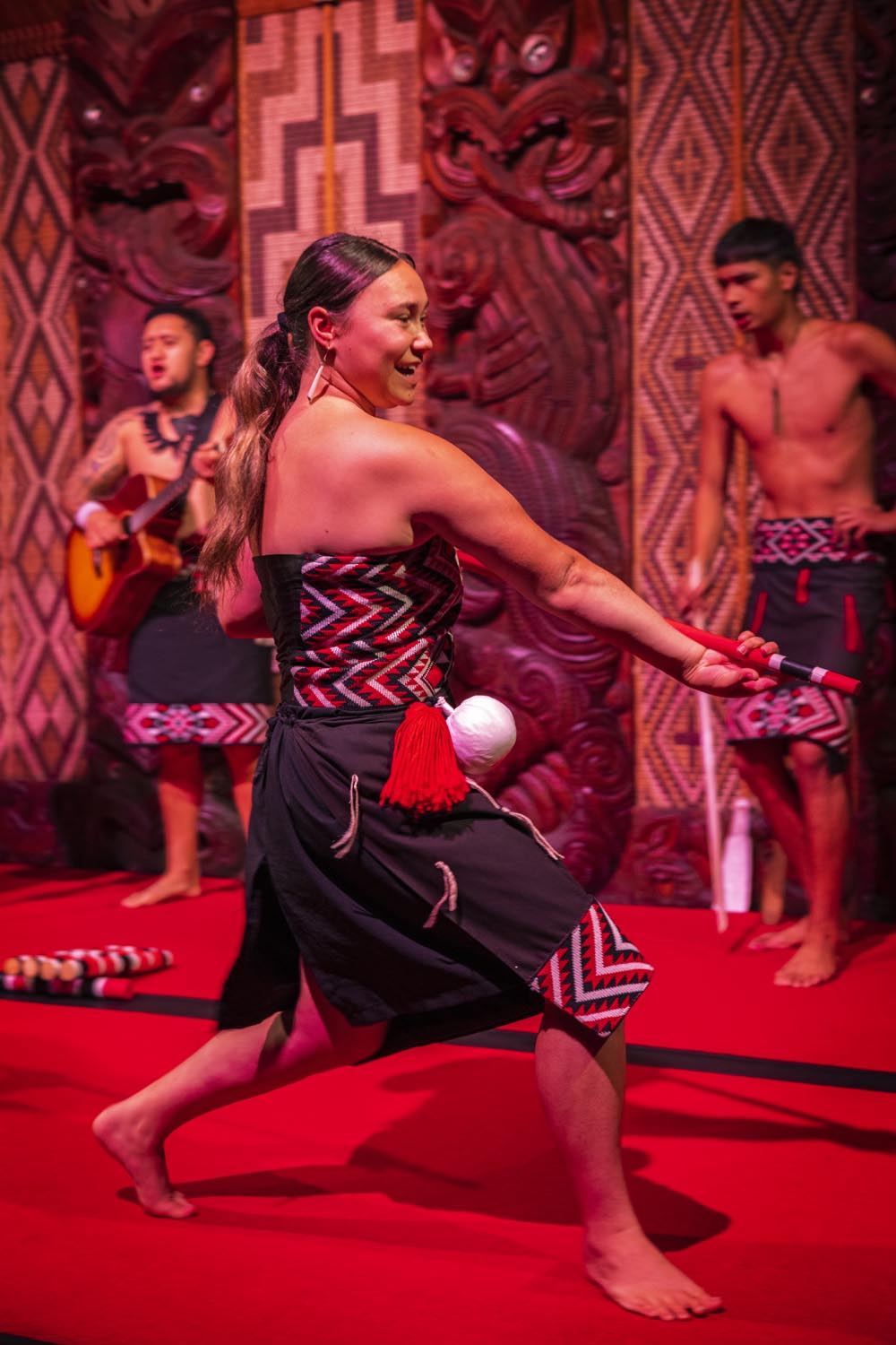
Following in the wake of the cyclone, our shifting itinerary still includes a visit to the North Islands Bay of Islands and the site of the Waitangi Treaty Grounds. Our Māori hosts escort us over grassy slopes. We stop to see the world’s largest ceremonial waka, a war canoe intricately carved and painted for the centenary of the Treaty of Waitangi’s signing in 1940, then renovated in 1974 for Queen Elizabeth II’s visit to Waitangi. We pass by the Te Kongahu Museum of Waitangi, and the Price of Citizenship Museum. Arriving at the meeting house, Māori performers greet us with a powhiri, a booming welcome, before inviting us inside the Te Whare Rūnanga for a Kapa Haka cultural performance. I recall Sienna’s suggestion that before embarking on the Orion we visit the War Memorial Museum and Toi o Tāmaki, the Auckland Art Gallery for their outstanding, informative displays of Māori arts and culture. It gives me a sense of context for what I see now at Waitangi. At Waitangi, this space is similar in intention to the Te Marae Atea Māori Court at the Auckland War Memorial Museum, but populated with dancers, singers, and guests. In both spaces I respectfully remove my shoes and enter.

The wharenui represents an ancestor: the threshold its mouth, the central ceiling beam its spine, the heke or rafters representing the ribs, and the side archway its extended arms. The entrant is at once welcomed and encompassed by this sacred space designed for worship, problem-solving, and truth-telling—qualities that keep a community strong. I reflect on the carved figures in the War Museum’s wharenui of wayfaring ancestors who were some of the first to arrive here from other parts of the Pacific, and atua, Māori deities line the walls of the space. The intricately carved wood is pigmented with red and black lacquer and their pearlescent paua shell eyes glint in the low light of the wharenui. Leaving the Māori Court at the War Memorial Museum, I notice a young man seated on a folding chair drawing similar designs in his sketchbook.
Another display at the War Memorial Museum in Auckland taught me something about struggles past and present. I viewed a photographic exhibit with didactics of the 506-day occupation at Auckland’s Bastion Point in 1977-78, protesting over a planned high-end development on that property and demanding rights of Māori to the land of the Ngati Whatua Reserve. Here at Waitangi Treaty Grounds, the Price of Citizenship Museum extends this narrative to a larger arc of time. At the entry a sign reads, “Te Rau Aroha Museum of The Price of Citizenship fosters the understanding that the struggle by Māori for equality as citizens in their own country has come at a high cost, with effects that are felt in many communities today. The museum allows all visitors to reflect on the ‘price of citizenship’ in their own lives and circumstances.” By 1918, after initial objections from the Crown to enlist Māori, several thousand Māori soldiers, known as the Māori Pioneer Battalion, fought bravely in the First World War. In the Second World War, Māori leader Āpirana Ngata regarded participation in the war as “the price of citizenship.”
The Treaty of Waitangi, initially promulgated on Feb 6, 1840, was written in English with a different document written in Māori, so that the 540 rangatira, Māori chiefs, and the British governors understood different interpretations and implications. I think of today how we can choose between news programs, depending on our predilections, both sides befuddled by the other. The Māori version of the document, Te Tiriti O Waitangi, described a relationship between Māori chiefs and the British that retained Indigenous sovereignty, but that allowed the Brits to control actions of ever growing, and much rowdier, groups of European settlers. The English version, however, described sovereignty as being ceded by Māori to the Crown, in exchange for protection. Beyond the fundamental question of sovereignty and self-determination, the question of who can own, buy, maintain, or sell land was a focal point of dispute in the wake of the treaty’s promulgation.
Over the ensuing decades, Māori looked to New Zealand’s founding document and voiced the discrepancies between the English and Māori language texts, pointing to breaches of the covenant signed at Waitangi. Still, the forces of settler colonialism — economic, political, and cultural — were set into motion and by the 1880s, Māori had become minorities in their own land, and were subject to all of the forms of violence and insult typical of a colonial apparatus: religious conversion to Christianity, punishment for speaking their language, the rendering of cultural and spiritual traditions that had long defined life for this part of the Pacific “illegal.” Between this and the introduction of muskets and the incitement of land wars, it was a century of upheaval and struggle for Māori people.
In 1975, the unstoppable Whina Cooper, a community activist throughout her century-long life, led a long walk at age 79 with fellow Māori from Te Hapua in Northland “the tail of the fish,” down the entire length of the North Island to Wellington. During the month-long 680-mile journey, fifty, then a hundred joined her, and the group kept growing, as more supporters joined in along the way, until over 5,000 Māori and sympathizers arrived at the Parliament grounds in Wellington. There on behalf of all Māori, Whina presented a Bill of Rights signed by over 200 Māori elders and a petition signed by 60,000 people to the Prime Minister Bill Rowling. In great part due to such efforts, as well as to Māori representatives in Parliament at that time, the Waitangi Tribunal was formed to hear Māori claims of breaches of the Treaty that defined the nation.
Our Lindblad staff Cultural Specialist Jenny Kingsley screens the biographical film “Whina” in the main salon noting that Whina Cooper stressed “the Spirit” of the Treaty, recalling, “that the Treaty was signed so that we could all live as one nation in Aotearoa.” Jenny comments that in the ‘70s the protestors at the Treaty Grounds were met with helicopters and armed police, and today, thousands come to celebrate Māori pride, waka launches, and performances, complete with concession stands, food, and dancing. The struggles continue, but along the journey, as more people join in, there are growing signs of progress toward a reclamation of Indigenous sovereignty on their own territory.


The celebratory spirit of the performers at the Treaty Grounds, the jade pounamu jewelry and carvings in stone and wood in the Museum gift shop, the installations in the Price of Citizenship Museum, and best of all, the hundreds of schoolchildren coming to discover, learn, and own their history make the Treaty Grounds at Waitangi feel like a strong, many-fibered rope woven to connect a rich ancestral past and the present.
What Remains with Me:
My thoughts again return to Toi o Tāmaki, the Auckland Art Gallery, founded in 1888, with installations that point to a sense of continuity between early and contemporary traditions. Māori artists such as Wi Taipa displaying tall, shapely punch-pattern ceramic vessels. Oil portraits of Māori kaumatua and rangatira, elders and chiefs, such as Kamariera Te Hau Wharepapa and Ahinata Te Rangitautini, a reputed healer, whose visage was captured at age 102 by 19th century artists such Gottfried Lindauer and C.F. Goldie. Complimentary to these heroic portraits of the past are the strikingly posed black and white photographic portraits of everyday working people by Glenn Busch. My thoughts return also to that Māori young man sketching a bold curvaceous design in his sketchbook, seated alone on a folding chair outside the wharenui of the Māori Court at the at the Auckland War Memorial Museum.
The intricate patterns of carved wood and ocean current, the glint of abalone paua shell, fetched from jade-colored waters, the spume of a surfacing whale, swirl in my mind and pull on me, and lure me back to this land of the long white cloud. We set out on a journey, with certain expectations, yet the challenge of any journey is in embracing what is, not what might have been. We follow the contours of three islands; The demigod Maui’s canoe, its anchor, and the fish he pulled from the sea. We skirt the edges of islands that were born, and continue to be reshaped by earthshaking quakes, volcanoes, winds, waves, and rain. Now, when I look through the lens of the stories, myths, and wayfaring tales, I can better grasp that the beautiful swirls of carved wood, the translucent green stone, and glinting shell eyes are born from a fierce and resilient spirit of the Māori. It is experience and imagination woven into a fabric of sea and land and stars, that create a map that charts unique and powerful ways of being in this world.


You must be logged in to post a comment.