

It started raining this morning. Just a sprinkle. Wasn’t on the weather app. But it sure felt like rain all day. I heard that it rained pretty hard briefly across town.
In the back of my mind, I keep thinking about the Super el Nino and the huge amount of rain that is expected over the winter. And as I understand it, that could start as early as November.
We bought our home in the lower downtown area about 25 years ago, and since that time I have known that it is in a flood zone. Each year, we shell out for the expensive flood insurance, and at the end of each rainy season we are grateful that so far, knock on wood, we haven’t needed it.
I can’t count the number of times that during heavy rain, I have walked over and checked the level in Mission Creek. Day and night. And I’m usually not the only one there with my powerful flashlight checking the level below the bridge.
The creek tends to fill quickly. Bath and De la Vina become rivers and water begins to stand in the side streets. It happens fast.
A few years ago, we came close to getting water in the house. Middle of the afternoon. It was one of those rains we read about often these days. Many inches of rain, sometimes measured in feet falling in a very short time. Our street flooded like I have never seen it. About two feet of flood water in the street and against the wall in front of our home. Many neighborhood houses had water in them. Several cars ruined near the creek. Thank God it stopped raining just in time.
My neighbor stood stoically in the street trying to stop the cars from plowing through the water quickly, creating waves and further flooding some of the more unfortunate homes. His picture, standing in near-waste deep water on Bath Street made the New York Times.
With climate change, my insurance company has told me that our house has a high likelihood of flooding. I wish it weren’t so.
Thankfully, combating all of this, the city and the County Flood Control District are improving the lower Mission Creek flow capacity and over the past decade or so have completed most of the creek improvements between our neighborhood and the ocean.
I do recognize that at high tide and with a significant tidal surge there is simply no place for the water to go. It could back up in the creek and surrounding neighborhood, but the increased capacity of the creek bed still helps.

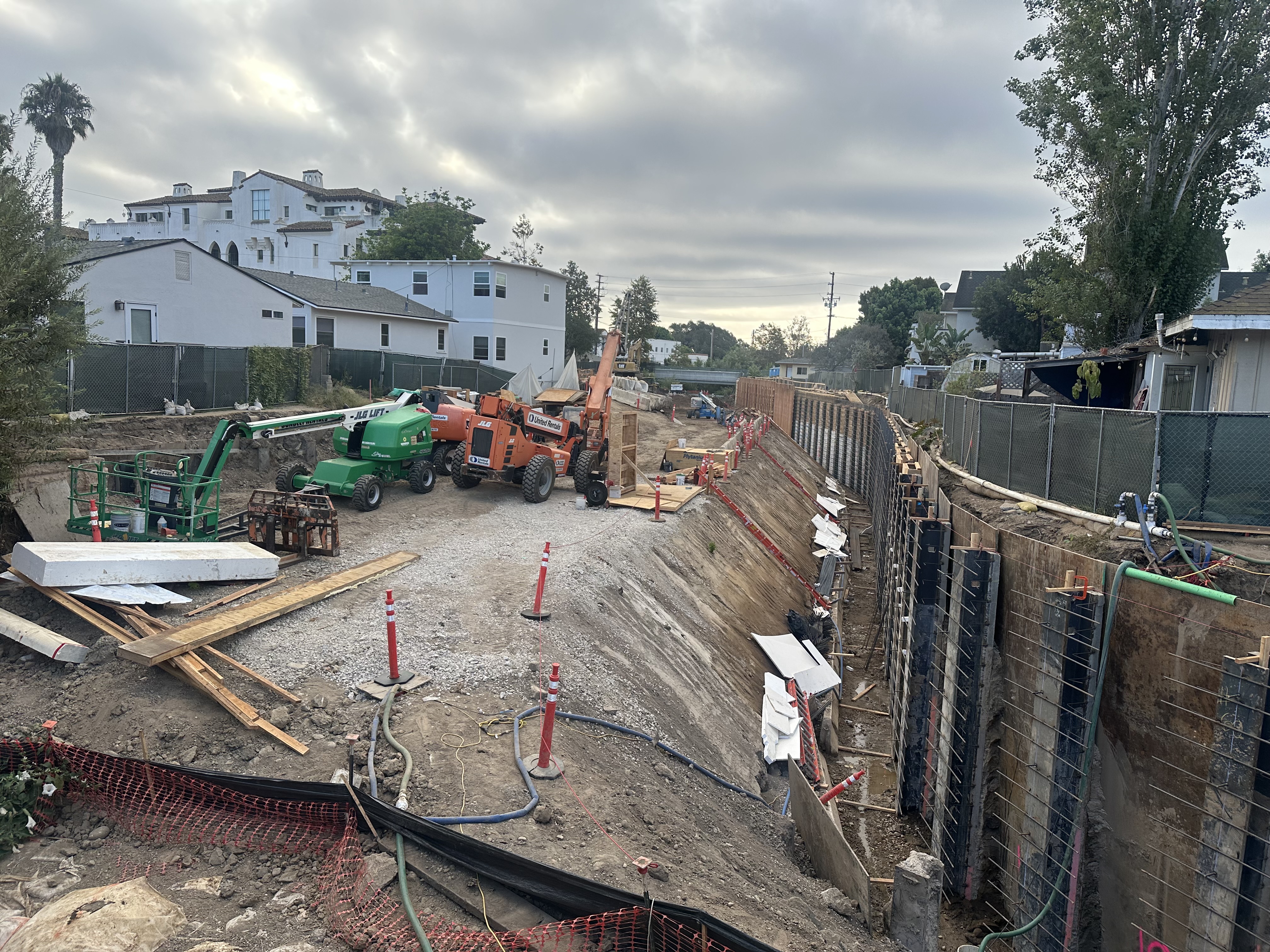
The current project phase (called Reach 4) is underway between Haley and Gutierrez. The second phase on this side of the freeway, it is an ambitious project that I have watched over the past several months. The crew works there five days a week, and the project is expected to be finished in November. It will be wonderful when it is complete.
The creek will flow much better all the way to the ocean. To make these improvements, however, the creek is currently filled with about 15-20 feet of temporary fill material from which the creek walls are being constructed. Fifteen feet of fill, the width of the creek for one city block. A lot of dirt. Heavy equipment sits atop the filled area to dig, drive the pilings, and construct the walls. It is an impressive engineering demonstration.
From the vantage point of the Haley Street bridge, it sure looks like the creek is largely blocked because of the fill and the platform it creates. In the spring and early summer, that seemed fine. But late in the summer and into fall, it is concerning. With all of the emergency preparedness in our community (especially related to fire), I have yet to hear anyone mention that Mission Creek is currently corked on this side of the freeway.
Our neighborhood has flooded with Mission Creek wide open in a normal year. Go stick your foot in the ocean. It’s warm. It’s not a normal year.
I am thankful for the project, but I am worried that at the current pace of work and with imminent Super El Niño, we are cutting it pretty close and the risk is huge.
Correction: The location in the photo is Mission Creek at De la Vina and Haley Street, not Cota Street.


You must be logged in to post a comment.