The first wave of a two-part storm system passed through Santa Barbara County early Friday, bringing localized flooding, downed trees, and rockslides, but no significant damage or injuries have been reported, according to officials.
“We haven’t seen any significant impacts from the storm,” said Scott Safechuck, public information officer for Santa Barbara County Fire. Despite a night of steady rain and slick roads, he confirmed that the region made it through the initial front largely unscathed.
Still, a second and more intense wave of the storm is expected to arrive late Friday night, with heavier bursts of rain forecast to hit the South County and Santa Ynez Mountains through Saturday evening.
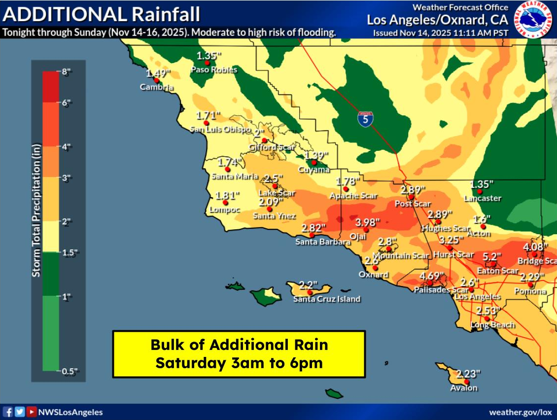
According to the National Weather Service, parts of the South Coast received 2 to 4 inches of rain overnight, while isolated mountain areas such as Rancho San Julian reported totals as high as 4.55 inches. The Santa Ynez Mountains recorded more than 5 inches in some locations. In contrast, North County saw lower totals — typically 1 to 2 inches.
Road conditions deteriorated in several areas overnight:
- Rocks and debris were reported across all lanes of Highway 154 west of Cathedral Oaks around 2 a.m.
- Minor flooding on northbound Highway 101 near Gaviota was reported just after midnight.
- Around 5 a.m., a vehicle became stuck in six inches of mud on Highway 101 near El Capitán State Beach.
- The California Highway Patrol responded to multiple traffic collisions on Highway 101, including crashes near Mission Street in Santa Barbara and Evans Avenue in Summerland.
- A Flash Flood Warning was issued for Solvang, Buellton, and Gaviota between midnight and 3 a.m., but expired with no major incidents.
The next phase of the storm is forecast to bring 2 to 3 inches of rain to coastal areas and 3 to 6 inches in the Santa Ynez Mountains, with bursts of heavier rainfall likely during a Flood Watch in effect from 1 a.m. to 10 p.m. Saturday.
“This storm will produce heavier bursts of rain over short periods, unlike the steady rain from the first storm,” the County of Santa Barbara noted in a Friday afternoon update. Officials are particularly concerned about runoff and flooding in vulnerable areas, especially near recent burn scars like those from the Lake Fire and Gifford Fire.
While no evacuation orders are in place, residents near these burn areas are advised to consider voluntarily relocating during breaks in the rain. “Do not wait for an official evacuation notice,” county officials warned.
Strong winds may accompany Saturday’s rainfall, increasing the risk of power outages and falling debris. Coastal areas may experience beach erosion, harbor flooding, and unstable bluffs—especially along Isla Vista and other high-risk shoreline zones.
Be Prepared
Local authorities are urging residents to take steps now to mitigate risk, including:
- Charge electronic devices, especially critical medical equipment
- Secure outdoor items vulnerable to wind, such as umbrellas and patio furniture
- Stay off flooded roads, and avoid riverbeds, creek beds, and recent burn areas
- Monitor alerts via ReadySBC, and visit ReadySBC.org for ongoing updates
The County also advises those near cliffside areas, such as Isla Vista bluffs, to be particularly cautious, as coastal erosion may be triggered by the combination of surf and precipitation.For road conditions, visit Caltrans QuickMap and County Road Closures.