

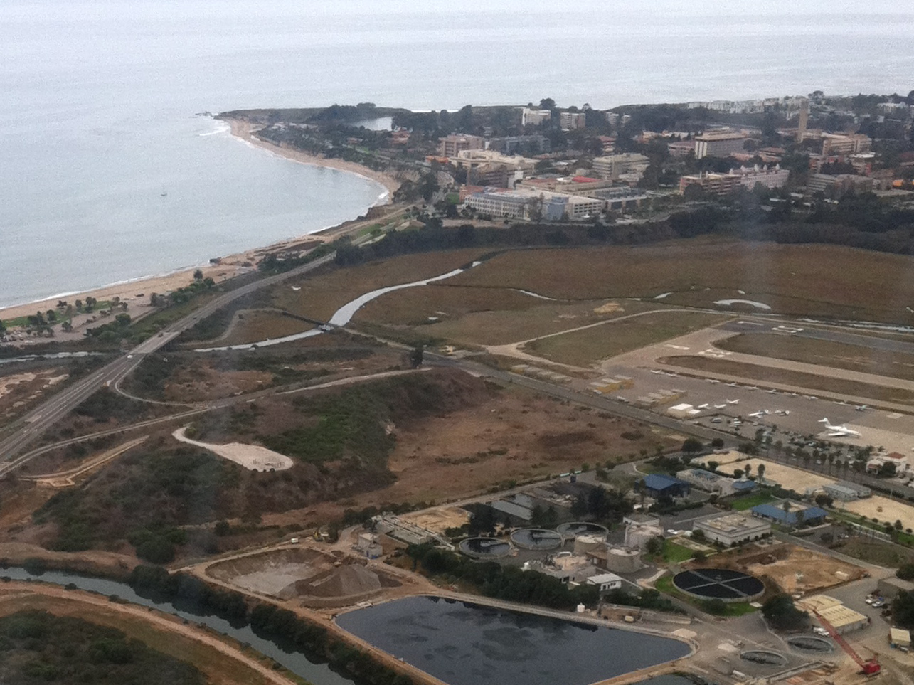
Speeding down Ward Memorial Boulevard, the freeway that links Highway 101 to the University of California, Santa Barbara, you might not even notice a small, unassuming hill on the righthand side.
Yet, beneath the modern rush, a forgotten story slumbers. This seemingly ordinary hill once thrived as He’lo, a vibrant island nestled within a bustling harbor, supporting two flourishing Chumash villages with an estimated population of over 800 inhabitants.
Centuries before European ships first sailed the Pacific, He’lo, encompassing roughly 64 acres, teemed with life as the most extensive urban area on the California coast. A verdant oak forest blanketed the island, providing a natural bounty akin to a grocery store. Acorns, a staple food source, were readily available, while the surrounding waters teemed with fish and shellfish.
The arrival of European explorers in the 16th century marked a turning point. In 1542, Juan Rodriguez Cabrillo and his crew sailed past He’lo, noting in their logs a large population living on the island and the adjacent mainland. Legend among the Chumash people even holds that Cabrillo, who died shortly after sustaining an injury during the expedition, is buried on He’lo.
Some time after this a Spanish schooner, or goleta, sank in the harbor and the area started to become known as Goleta. There were several other villages along the banks of the harbor, which eventually would be called the Goleta Slough.
The Spanish soldiers were impressed by this island in the middle of a bay, heavily populated by natives. It reminded them of an Aztec legend that involved a similar island in Nayarit, Mexico called Mexcaltitlan. That small hill is still referred to on maps as Mescalitan Island, derived from the name the Spaniards gave the island.
Further Spanish exploration in 1769, led by Gaspar de Portola, solidified the use of “Mescaltitlan” on early maps. Interestingly, these maps extended the name to encompass the entire Goleta Valley, reflecting the abundance of Chumash villages throughout the region.
The 19th century ushered in an era of drastic change. Uncontrolled grazing by European settlers, starting in the 1830s, ravaged the hills surrounding He’lo, leaving the land vulnerable to erosion. Two years of relentless flooding, from 1861 to 1862, transformed He’lo’s once-bustling harbor into a saltwater marsh. The island’s vibrant ecosystem began to unravel.
The arrival of Europeans and the subsequent changes to the landscape had a profound impact on the Chumash way of life. Diseases introduced by the Spanish decimated the Chumash population. He’lo was abandoned by the Chumash in 1803. Spanish missionization efforts further disrupted their traditional way of life, forcing many Chumash people to convert to Christianity and adopt European customs.
By the time John More purchased the land in 1876, which became part of his sprawling More Ranch, the Chumash presence on He’lo had dwindled significantly. More cultivated beans on the island and built a house that his sister, Catherine Briggs More, resided in for a time — a stark contrast to the way of life of the Chumash people who once thrived there.
The dawn of the world wars era brought a new purpose, not for He’lo itself, but for the adjacent land. World War I fueled advancements in military aviation, and the flat terrain near the island proved ideal for runways. However, instead of directly transforming He’lo into runways, vast quantities of earth were excavated from the island and used to fill in the low-lying salt marshes, creating a more stable foundation for the burgeoning Santa Barbara Municipal Airport.
Ward Memorial Boulevard further carved into the island’s diminishing size. Today, a water treatment plant stands sentinel on what remains of He’lo, a silent guardian of a lost civilization.
While He’lo faded into obscurity, a new story unfolded nearby. In 1891, a modest teacher training institution called the Santa Barbara State Normal School (SBS) was established. This was the genesis of the mighty UC Santa Barbara. Little did anyone know that this trade school would blossom into a world-renowned university.
The visionary architect of UCSB’s transformation was none other than Thomas More Storke, a prominent newspaper publisher who won a Pulitzer Prize and was briefly a U.S. senator. Recognizing the potential of SBS, Storke lobbied tirelessly for its expansion. Notably, he played a pivotal role in convincing the U.S. Navy to relinquish control of its Goleta campus, paving the way for UCSB’s physical growth.
As UCSB expanded, a unique community sprouted next door — Isla Vista (I.V.). Initially, vast agricultural fields surrounded the fledgling university. However, post-World War II saw a surge in student enrollment, necessitating the development of housing and commercial enterprises to cater to their needs. I.V. transformed from farmland to a bustling student enclave.
The physical campus of UCSB mirrored this growth. Once a collection of modest buildings, the university sprawled outward, incorporating diverse architectural styles. Today, UCSB boasts a vibrant campus with state-of-the-art facilities, research labs, and iconic landmarks like the Storke bell tower.
Despite its humble beginnings, Isla Vista has evolved into a vibrant cultural hub, boasting eclectic eateries, lively music venues, and a strong sense of community spirit. The streets of Isla Vista come alive with the rhythm of student life, offering a kaleidoscope of experiences for residents and visitors alike.
The relationship between UCSB and Isla Vista has been a complex dance. The university’s growth fueled the local economy but also strained resources. Concerns about student housing, noise levels, and parties have created friction at times. However, collaborative efforts between UCSB and I.V. residents are fostering a more harmonious coexistence.
The stories of Mescalitan Island and Isla Vista, woven together with the rise of UCSB, illustrate the dynamism of the Goleta Valley coastline. From a thriving Chumash settlement to a bustling university town, the landscape has undergone a remarkable transformation.
As UCSB continues to evolve and Isla Vista grapples with its identity, one thing remains certain: the coast of Goleta Valley will continue to be a canvas for change, forever etched with the stories of the past, present, and future.
