• CREATE AN ACCOUNT
  • LOG.IN
  • CONTENTS
  • CLASSIFIEDS
  • ARCHIVE
  • INFO | ADVERTISING | CONTACT US

  • Home
  • News
    • News Main Page
    • NewsFlash
  • A&E
    • A&E Main Page
    • Movie Times
    • TV Listings
    • A&E Blog
    • Art Galleries
    • Best Bets
  • Opinion
    • Opinion Main Page
    • Blogs
    • Columns
    • Voices
    • Letters
    • In Memoriam
    • Obituaries
  • Events
    • Today
    • Search
    • Submit
    • Best Bets
  • Living
    • Living Main Page
    • Outdoors
    • Travel
    • Sports
    • Peeps
  • Food & Drink
    • Food & Drink Main Page
    • All Restaurants
    • Delivery
    • All Bars & Clubs
    • Drink Specials
    • Open Now
  • Sports
  • Outdoors
    • Outdoors Main Page
    • Outside Insider
    • Spotlight On
    • Features
  • Classifieds
    • Real Estate
    • Jobs
    • Autos
  • Obits

Ray Ford

Massive firestorm over little Pine Mountain is the reason for the ash raining down on Santa Barbara.


Zaca Fire Explodes

Moves Three Miles After Days of Quiet


Friday, August 3, 2007
By Ray Ford (Contact)
Article Tools
Print friendly
E-mail story
Contact an Editor
iPod friendly
Comments
Bookmark This
del.icio.us. del.icio.us.
Digg! Digg!
furl furl
google google
newsvine newsvine
reddit reddit
technorati technorati
Facebook Facebook
Yahoo! My Web 2.0 Yahoo!
View from Live Oak Fire Camp at Noon today.
Click to enlarge photo

Ray Ford

View from Live Oak Fire Camp at Noon today.

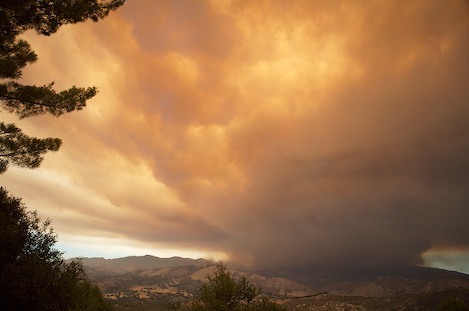
After several days of relatively little movement, the Zaca Fire exploded, advancing more than three miles within a few hours this morning. At 9 a.m. there was little indication the fire was ready to move, with the smoke and fire contained to isolated locations near Santa Cruz Peak and further north near the Mission Pine Ridge.

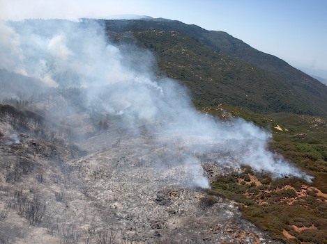
However, by 11 a.m. the fire was cooking. At Live Oak Fire Camp the thunderhead could be seen building and was so large it appeared as if it were threatening the camp itself. However, from the observation point near Santa Marcos Pass it was clear the fire line was moving rapidly to the east, eating up huge chunks of the upper parts of Santa Cruz Canyon.

Ray Ford

Massive thunderhead of smoke fills the sky over Little Pine Mountain. More than 4 miles wide, 100' high flames can be spotted at times. The fire line threatens to cross Buckhorn Road this afternoon.

By 1 p.m., the towering thunderhead was located almost directly over Little Pine Mountain and to the north, more than likely burning out the East Fork of Santa Cruz drainage.

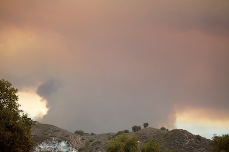
Fire officials have decided to issue an evacuation warning for the Paradise area and residents should be notified shortly. They are also in discussions as to whether to close Paradise Road to the public as well.

Map of Zaca Fire, August 3, 2007
Click to enlarge photo

Zaca GIS section

Map of Zaca Fire, August 3, 2007

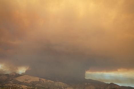
Further into the interior, the fire is threatening to move over the crest of Mission Pine ridge and head down towards the Sisquoc River. Yesterday, afternoon the fire crossed Mission Pine Trail west of the Basin and uphill to a point where it could start downhill into the Sisquoc drainage. Today, the drama in this area has been overshadowed by the rapid expansion of the fire line north of Little Pine.

Courtesy of Forest Service

Fire moves across the Mission Pine ridge and threatens to move into the Sisquoc.

Courtesy of Forest Service

On Thursday the fire crossed Mission Pine Trail just west of the Basin. Hot shots have been sent in from both sides in an attempt to build line around the breach. A DC-10 capable of carrying 10 ton loads of retardant will be used to day to support them.

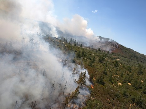
Though this rapid movement of the fire line may actually be good news for the Paradise residents, it represents a major expansion of the fire. Tomorrow we may be talking about a fireline that extends east into the Dick Smith Wilderness.

Story Help (Click-ability)
Double-clicking on any word or phrase in this story will open a reference window with definitions and links to other reference material.

Comments

Discussion Guidelines

Thanks again for the story Ray. I'm sure a lot more people will be wondering what is going on now that ash is coming down like never before in this fire.

pope (Paul Costales)
August 3, 2007 at 5:10 p.m. (Suggest removal)

Your photos are incredible and very much appreciated. It's hard to fathom the destruction. I climbed to the top of Little Pine Mt. several years ago and there were towering pine trees at the top. I hope they survived.

lopeti (anonymous profile)
August 4, 2007 at 4:09 p.m. (Suggest removal)

Post a comment

Username:
Password: (Forgotten your password?)

Comment:

EVENT CALENDAR

Previous Month | Next Month

Today's Events Best Bets Submit an Event

Local Weather

Currently:
Haze
Temperature:
66.0°
Wind:
9 SSW

Surf Report
  • Specials
  • InPrint
  • Top Emails
  • Wedding Guide 2009
  • SBIFF 2009
  • Local Heroes 2008
  • Best Of 2008
  • Tea Fire 2008
  • Blue Green Guide 2008
  • 2008 Election Coverage
  • Calendar of Fundraisers
  • Local Bands
  • Kid's Mother's Day Issue
  • Made in Santa Barbara
  • Summer Reading
  • Santa Barbara Reads 2009 Chooses Fahrenheit 451
  • East Beach Water Contamination Mystery Continues
  • El Corazón del Perro
  • The Stone Foxes Return to Rock’s Roots
  • Horseback Riding Helps Local Vets
  1. Cottage, Sansum May Fuse
  2. Pacific Capital Bancorp Refutes Takeover Gossip
  3. Santa Barbara Named One of “Ten Pricey Cities That Pay Off”
  4. Santa Barbara Scrapbooks to Close Its Doors
  5. Official Michael Jackson Party Announced
  6. Deceased Man Found in Car on Coast Village Road
  • CREATE AN ACCOUNT
  • LOG.IN
  • CONTENTS
  • CLASSIFIEDS
  • ARCHIVE
  • INFO | ADVERTISING | CONTACT US
Google
 
Independent.com Web
Copyright ©2009 Santa Barbara Independent, Inc. Reproduction of material from any Independent.com pages without written permission is strictly prohibited. If you believe an Independent.com user or any material appearing on Independent.com is copyrighted material used without proper permission, please click here.
This is our Privacy Policy.