For those who are wondering when the Tunnel Trail or Jesusita will be re-opened in the Mission Canyon area, the answer seems to be pretty clear: not soon enough for some and way too soon for others.
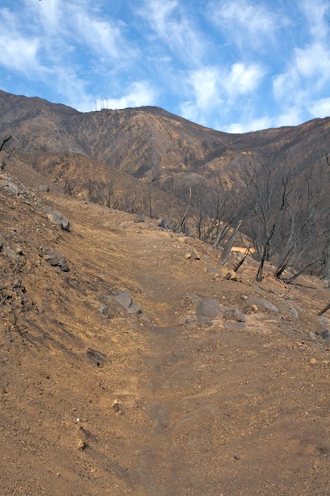
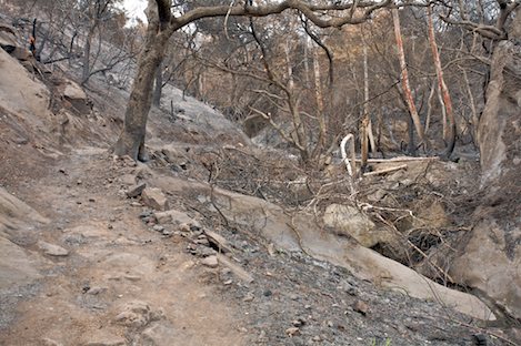
First there is the question of rock fall, especially after the recent rain. Those who have seen the upper part of Mission Canyon know firsthand how devastated the area has been hit.
Recently I visited the area in the company of several USGS employees who were scouting out locations to place a weather station to monitor the winter storms. As we reached the locked gate at the top of Tunnel Road, the impact of the fire’s damage was immediate and to put it succinctly — overwhelming.
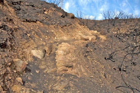
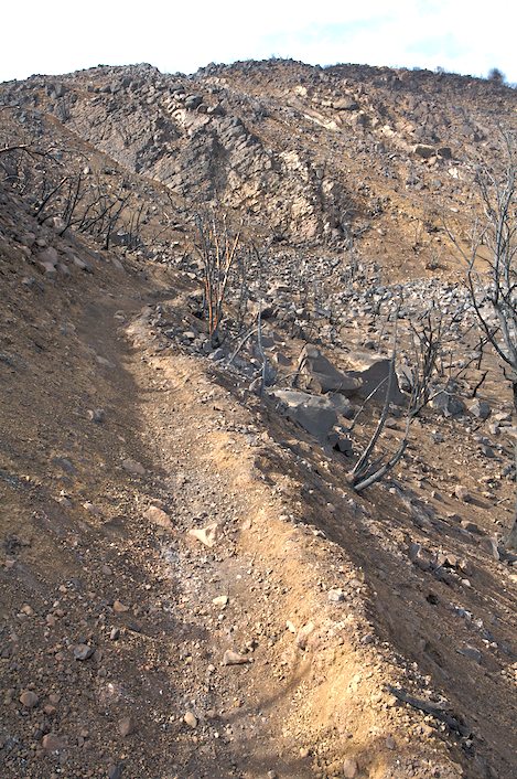
Simply put, with the exception of the lower canyons, a few small creases and the backsides of a handful of hillsides, the vegetation is gone. Though the hillsides are somewhat stable now, that may not be the case in October or November when the first major rainstorm hits.
The feeling is almost beyond words. This is country I’ve visited hundreds of times, smelled the aromas and walked up the road and trails without a thought to what the hillsides might look like if stripped bare. Most of the rocks and dirt-covered slopes are black, more vertical looking without the thin mantle of chaparral vegetation, and fragile looking at best. Thousands of rocks cling to the hillsides with nothing but a few bits of dirt to keep them in place. Many will come tumbling down, whether next week or in the first storm, no one can say for sure.
Another one of the difficulties that concerns Santa Barbara City and Forest officials is the ability to head off trail more or less anywhere along miles of trails. With little to hold the hillsides in place, having hundreds of people scrambling anywhere is worrisome. Not only does this impact erosion issues but there is a tremendous potential for rock to come tumbling down on the trails or roads below. Then there is also the potential to cut switchbacks, create new routes to other parts of the trails, especially Tunnel Trail, which has almost no vegetation its entire length.
While trail enthusiasts may scream at the thought of the trails being closed for some additional period of time — throughout the summer months for instance — the argument can be made that by doing so will not only allow residents in Mission Canyon the opportunity to rebuild their lives without having to deal with the traffic that comes with trail access, but provide time to do more than the usual minimal maintenance to them.
As a long-time trail user, I’ve been out on our local front country trails in most every type of weather or season. I’ve seen them in good times and bad, from the ultimate in experience to mucking my way through tons of mud as a part of the efforts to clean up the mess after the 2005 flood season.
Along with hundreds of others I’ve helped rebuild them, not to perfection, but to withstand another few years of use.
These are trails that were designed for another era or users and another century’s idea of what a trail should be. Now we have an opportunity to take a timeout, a deep breath, and spend a few months looking at how we might rebuild these trails to serve 21st Century needs.
The point may be a moot one: either those who clamor for them to be open will force the issue and the fire-damaged trails will open in a few weeks or those who demand that they stay closed will have their way but no one will jump on what is a rare chance to rebuild the trails.
Regardless, the opportunity is there to consider how best to take this time to rebuild the trails and how to go about it.
Related Links
Double-clicking on any word or phrase in this story will open a reference window with definitions and links to other reference material.

Print friendly
E-mail story
Tip Us Off
iPod friendly
Comments
Bookmark This


Previous Month


Comments
Discussion Guidelines
I agree that the Jesusita fire offers a good opportunity to rebuild the front-country trails.
I personally would like to see a new trail that travels horizontally above the city -- from Goleta to Montecito, or maybe all the way to Carpenteria. The trail should be relatively gentle in grade and designed for people walking.
Boulder, Colorado, offers a great example of what I am talking about. The "Mesa Trail" connects the fields of wildlflowers above Chautauqua park to the sheer cliffs of Eldorado Canyon State Park, travelling horizontally across the mountains above the city. It creates a lot of wonderful loop hike opportunities as it crosses trails that travel up canyons, much like the trails here. It traverses very rugged terrain while rolling gently up and down, making it an ideal place for people of all ages and abilities to get out into the mountains. And runners absolutely love it.
I think building a trail like the Mesa Trail in Santa Barbara's front country would be a great way to enhance our trail system as we rebuild and recover from the fire.
Readers say: Thumbs Up: 0 of 0 • Thumbs Down: 0 of 0
Travis (anonymous profile)
June 9, 2009 at 12:03 p.m. (Suggest removal)
I agree with idea to take time and have a trail that will be as reasonably erosion resistant and stable as possible given soil type and grading affects.Lack of ground cover will cause less stability but rebound recurrs rapidly sometimes and hopefully with native species.I think rushing and having loose rocks and boulders bouncing down the hills is something the County wants to avoid.By the way is the land National Forest?County Land or Easment? or mixed Private and public land?
Readers say: Thumbs Up: 0 of 0 • Thumbs Down: 0 of 0
rabbitrun (anonymous profile)
June 10, 2009 at 10:22 a.m. (Suggest removal)
I think that a Santa Barbara Front Country Trail like the Mesa Trail in Boulder would be incredible! Thanks for posting Travis. But, even as I contemplate the idea, I begin to consider the obstacles and barriers that would impede (but not necessarily "prohibit") the idea. Rabbitrun asks an important question regarding ownership and jurisdiction. Who knows who owns all the land that such a trail would traverse? I would bet that it is a complex matrix of many individual private owners, conservancies, County, City, State and Federal parcels and easement dedications. Many private landowners in the front country have already staked their rights of exclusivity and have barred the public from entering their property, even where historic trails already existed (i.e. Arroyo Burro Trail) The first hurdle would be somebody proposing a reasonably viable corridor for the trail. Who would that be? Then a process of identifying ownership and easement dedication would follow. Every public jurisdiction involved would have a stake and process to wade through. Santa Barbara County alone would have several agencies contribute their two cents: Planning and Development, Parks, Flood Control, Fire. Then there is the State Lands Commission, State Forest, Fish and Game. Parts of the trail would pass through the City of Santa Barbara which would probably involve Parks and Recreation, Creeks Advisory Committee, etc. And, oh yeah, the Federal government; Los Padres National Forest, EPA, Bureau of Land Management, Department of the Interior.... To do it "right", through a formal permit process, could be lengthy and expensive, involving Environmental Impact Reports, geology and hydrology studies, many public hearings, land use attorneys and lots of cash... and that's before the real work of building the trail even begins. Daunting. And would the trail be exclusive to foot traffic, or would it democratically include cyclists and equestrians? On the positive side, there are a lot of community groups that could have a positive influence on the process; Montecito Trails Foundation, Los Padres Trail Riders, Santa Barbara Mountain Bike Volunteers, the County Hiking and Riding Trails Advisory Committee, Sierra Club, even the Boy Scouts of America, etc. could contribute ideas and resources toward the realization of a dream trail for use by all. I have not heard, are any of these groups already undertaking and collaborating on the re-building process and the development of new trail corridors? I hope so, that would be good news. Mr. Ford, I think there's a serial story here for you.
Readers say: Thumbs Up: 0 of 0 • Thumbs Down: 0 of 0
elpesto (anonymous profile)
June 10, 2009 at 12:02 p.m. (Suggest removal)
Yes, thank you, Ray. The trails should probably remain closed at least until the end of the upcoming rainy season because of the drainage and stability issues you raised. Some people are currently using the trails even though they are officially closed. It will take time for the land to heal. We will all be better off in the long run if human activity in the Jesusita fire area is limited until the natural regrowth of fire succession vegetation occurs and drainage and erosion issues are addressed.
Readers say: Thumbs Up: 0 of 0 • Thumbs Down: 0 of 0
nonni (anonymous profile)
June 15, 2009 at 9:01 a.m. (Suggest removal)
I honestly think this is a great time to take many of these trails and make then 21st century. But at the same time make them accessible to emergency vehicles. Use a Dozer ( small to medium one ) and what ever else not and make these into fire roads. I know this might seem drastic to a few people but this would help so much with management and control of fires. Plus with injuries of Hikers or Mountain Bikers.
The Mesa Trail idea is a wonderful idea. I honestly think this could be done quit simply just by calling it a fire road. Doing that could alleviate much of the permit and red tape issues.
Just my two cents.
Readers say: Thumbs Up: 0 of 0 • Thumbs Down: 0 of 0
Thisislame (anonymous profile)
July 31, 2009 at 10:20 p.m. (Suggest removal)
Maybe I am just an old wilderness guy, but how does walking differ between the 21st and 20th centuries? One foot ahead of another, follow the trail. People still have two feet. Dozers? Are people now this lazy that they need a flat, wide open trail? Don't want to touch any brush with your clean clothes?
Readers say: Thumbs Up: 0 of 0 • Thumbs Down: 0 of 0
DG (anonymous profile)
August 20, 2009 at 10:07 a.m. (Suggest removal)
Post a comment