

[Update: Nov. 26, 11 a.m.] The Cave Fire has grown to more than 4,300 acres as of 11 a.m. Tuesday, according to Police Spokesperson Anthony Wagner. Wagner said the 29-year-old vegetation is still burning well above Santa Barbara’s foothills, and beneficial rain is due within 24 hours.
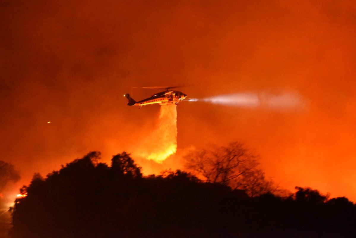
Air assets, dozers, hand crews, and more than 500 firefighters battled the blaze, and new crews are arriving this morning to relieve the firefighters who worked through the night.
N95 masks are available to the public at the Main Santa Barbara Library until 7 p.m. today. The Yanonali Annex Yard is staffed from 8 a.m. to 4 p.m. today and Wednesday to distribute sandbags to the public.
[Update: Nov. 26, 10 a.m.] The Cave Fire continues to burn uncontrolled and is now at over 4,100 acres with zero containment, prompting the county to secure federal grant money from the Federal Emergency Management Agency to help fight it. The grant will fund up to 75 percent of eligible firefighting costs.
The county’s Public Health Department and the Santa Barbara County Air Pollution Control District have issued an air quality warning. The announcement asks residents to avoid spending time outside and to wear a properly fitted N95 mask when outside. They also tell Santa Barbarans to use the recirculate option on car air conditioners while driving.
Here is an update on closures:
- There are closures along the 154 at State Route 246, State Route 154 and State Route 192, according to the Santa Barbara California Highway Patrol Office. The CHP is directing residents to use Highway 101 as an alternate route and to stay away from the 154.
- Santa Barbara City College closed all three of its campuses today and tomorrow as a precaution.
- Although schools within the Santa Barbara Unified School District are closed for the Thanksgiving Holiday, several programs that would have otherwise been open also closed in the Wake of the Cave Fire. The Early Years infant/toddler Program at Santa Barbara High School closed through Wednesday, and all full-day after school programs are closed through Wednesday.
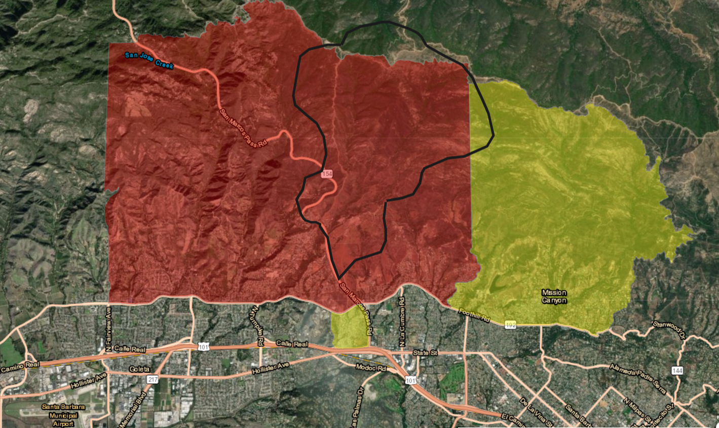
[Update: Nov. 26, 7:30 a.m.] As of 7:30 a.m., the Cave Fire was estimated at 4,100 acres with zero containment. Six hundred firefighters from multiple agencies were on it and at least ten air tankers dispatched to beat down the flames that took off yesterday at 4 p.m. by San Marcos Pass and Camino Cielo.
As firefighters assess last night’s damage, it appears at least one structure — an outbuilding — has been damaged or destroyed. About 15,000 homes remain threatened and authorities state that 4,170 evacuations have been documented.
Firefighters expect the fire to encompass up to 5,000 acres by the end of day two. The terrain is still and hard to access, fueled by chaparral standing six feet high and wild grasses about 2 and a half feet. For the moment, the winds are pushing from the coast and back up the mountains with the relative humidity at 40 percent.
Last night at 10:30 p.m., Santa Barbara County proclaimed the Cave Fire as a local emergency. “These conditions are beyond the control of the services, personnel, equipment, and facilities of the combined forces of the county’s operational area to combat,” the announcement states. “Additional resources have been ordered from out of the area, which have been arriving all evening.”
[Update: Nov. 25, 9:40 p.m.] A fire that started around 4 p.m. at about 15 acres has now mushroomed into about 3,300 acres running downslope from Camino Cielo and Highway 154, jumping both sides of San Marcos Road by the Bridge to Nowhere about a mile north of Cathedral Oaks Road.
There are rumors that some structures are engulfed by the wind-driven flames, but thus far no confirmation. Mike Eliason, spokesperson for the county fire department, said crews are wetting down eucalyptus groves located near residential areas by Via Clarice. Eucalyptus trees don’t just burn; they explode.
For people around during the Painted Cave Fire of 1991, this inferno brings back spooky memories. The Painted Cave Fire — since re-christened the Paint Fire — jumped the freeway and nearly gobbled up Hope Ranch. This fire, dubbed the Cave Fire, has a similar point of origin and is expanding at an alarming rate. Depending upon where you stand, the winds continue to blow hard and steady, 30 miles an hour where it counts.
For a while it appeared the fire might run downhill to the county jail, but according to Sheriff’s Department spokesperson Raquel Zick, the fire split off to the east and west before it could pose an immediate threat. If it comes to it, she said, the jail was built so that its inhabitants can shelter in place.
Four helicopters — from Santa Barbara County Fire and the Los Angeles County Fire Departments — are airborne dropping water on the fire as dozer crews down below attempt to gouge out defensible breaks and hand crews try to mop up the flames. Independent photo editor Paul Wellman said the copters were drawing water from Laurel Reservoir. He also said Ontare Road is being evacuated north of Foothill Road. As far as the winds, Wellman said they appear to have mellowed down considerably on Old San Marcos Road, but were strong enough to knock a person down up on Camino Cielo. The fire, he said, was making a serious run at the Old San Antonio Creek neighborhood, which got seriously scorched before by the Paint Fire.
[Update: Nov. 25, 8:20 p.m.] As the Cave Fire grows, the evacuation order has extended farther west to Fairview Avenue, north of Cathedral Oaks, County OEM just alerted. (Go to ReadySBC.org to sign up to receive emergency alerts.)
The evacuation warning now includes the area from the 154 to El Sueno Road from Calle Real/Highway 101 to Cathedral Oaks Road, reported Raquel Zick, Sheriff’s Office press information officer.
A shelter for evacuees has been set up at the Goleta Valley Community Center, 5679 Hollister Road.
Small animals can be taken to the animal shelter in Goleta, 5473 Overpass Road, after first calling (805) 681-4332. Large animals can be taken to Earl Warren Showgrounds, 3400 Calle Real, in Santa Barbara.
Emergency information can also be heard on the county’s collaborative emergency network with the following radio stations:
FM Stations:
88.3 KCLU NPR (South Coast)
94.1 KOSJ (South Coast)
94.5 KSPE SPANISH (Countywide)
99.9 KTYD (South Coast)
101.7 KLITE/KSBL (South Coast & Santa Ynez)
102.3 KCLU NPR (South Coast)
107.77 KIST SPANISH (Countywide)
AM Stations:
1490
KOSJ (South Coast)
1290
KZSB (South Coast)
1340
KCLU NPR (South Coast)
[Update: Nov. 25, 8 p.m.] The evacuation warning area extends from Patterson west to Fairview, and from Ontare east to Gibraltar Road — a warning is an advisory to get ready to go; the other orders are mandatory. Fire Captain Daniel Bertucelli, speaking with KEYT, said he’d seen fire all the way down the east side of the 154 to Cieneguitas Road. On the west side of the 154, the fire was near San Antonio Creek Road.
He estimated the fire at 500 acres and said he’d heard a helicopter working the lower part of the fire, where the winds were milder. Up at the top of the hill, he estimated 40 miles per hour winds. He later confirmed the Firehawk helicopter from Los Angeles County Fire was on scene.
[Update: Nov. 25, 7:30 p.m.] The evacuation order for the Cave Fire has expanded to Patterson Road and Cathedral Oaks from the 154 as of about 7:15 p.m. The evacuation orders continue for Ontare Road to State Route 154 from East Camino Cielo to Foothill Road.
High wind gusts of 31 miles per hour out of the north-northeast are driving the fire to the southwest and downhill toward more populated areas. Firefighters from Santa Barbara County and Los Padres National Forest were on scene as of the last report from County Fire at about 5 p.m.
Southern California Edison is cutting power to the Painted Cave area, Independent photographer Paul Wellman reported.
[Update Nov. 25 7:14 p.m.] There is still no official size for the rapidly growing fire that began at just 10-15 acres, however it is estimated to be as much as 100 acres. The fire is currently zero percent contained and is burning along both sides of East Camino Cielo Road, according to Santa Barbara County Fire spokesperson Mike Eliason. It is wind-driven, he said, and it’s quickly burning downhill with embers spotting far ahead of the fire line.
Eliason said one helicopter is currently in the air attempting to gauge the footprint of the fire, but the county ordered aircraft with night-vision capabilities from Los Angeles and Ventura counties. Eliason cautioned, though, that it’s too soon to speculate when the aircraft might be available because the winds are gusting at 30 miles an hour by San Marcos pass, make flying challenging.
Voluntary evacuation warnings have been issued for the area between the 154 and Fairview, and for the area between Ontare and Gibraltar Road, but the only mandatory evacuations so far are still only for residents living in the Painted Cave area between East Camino Cielo and Foothill Road, and Ontare to Highway 154.
An evacuation center is open in the Goleta Community Center at 5679 Hollister Avenue. For assistance evacuating animals, call (805) 681-4332. Earl Warren Showgrounds is open for large animal evacuations.
The fire is under the jurisdiction of the Los Padres National Forest fire fighters. A type II incident command has been established to better marshal resources from Los Padres, the county, cities of Santa Barbara and Goleta, and Montecito fire departments. They are in the process of establishing an incident command post at the county fire department.
Winds are currently blowing at 20-25 miles per hour with gusts up to 40 miles per hour.
[Original Story] First responders are fighting a fire that erupted on top of the El Camino Cielo Ridge Monday around 4 p.m. and is continuing to spread rapidly, forcing evacuation orders for all 1,700 residents living in the Painted Cave area between East Camino Cielo and Foothill Road, and Ontare to Highway 154.
Firefighters are still arriving on the scene, the exact number of first responders deployed is still unclear. Police Spokesperson Anthony Wagner said the ridge hadn’t burned in over a decade, which may account for how quickly the fire is spreading.
“We are always ready to give aid at a moment’s notice,” Wagner said. “Residents should listen to all directions from emergency personnel and heed all warnings. If asked to evacuate, don’t chance it; it isn’t worth life.”
The smoke from the fire appears to be headed toward Santa Barbara City proper. We will update this story as new information becomes available.


You must be logged in to post a comment.