
Santa Barbara County Redistricting, Continued … Literally
Latest Map Adds Supervisor Lavagnino Back to the 5th District


Anyone who has followed the work of Santa Barbara County’s first Citizens Independent Redistricting Commission (CIRC) will tell you this: expect the unexpected.
Last night’s meeting was no exception.
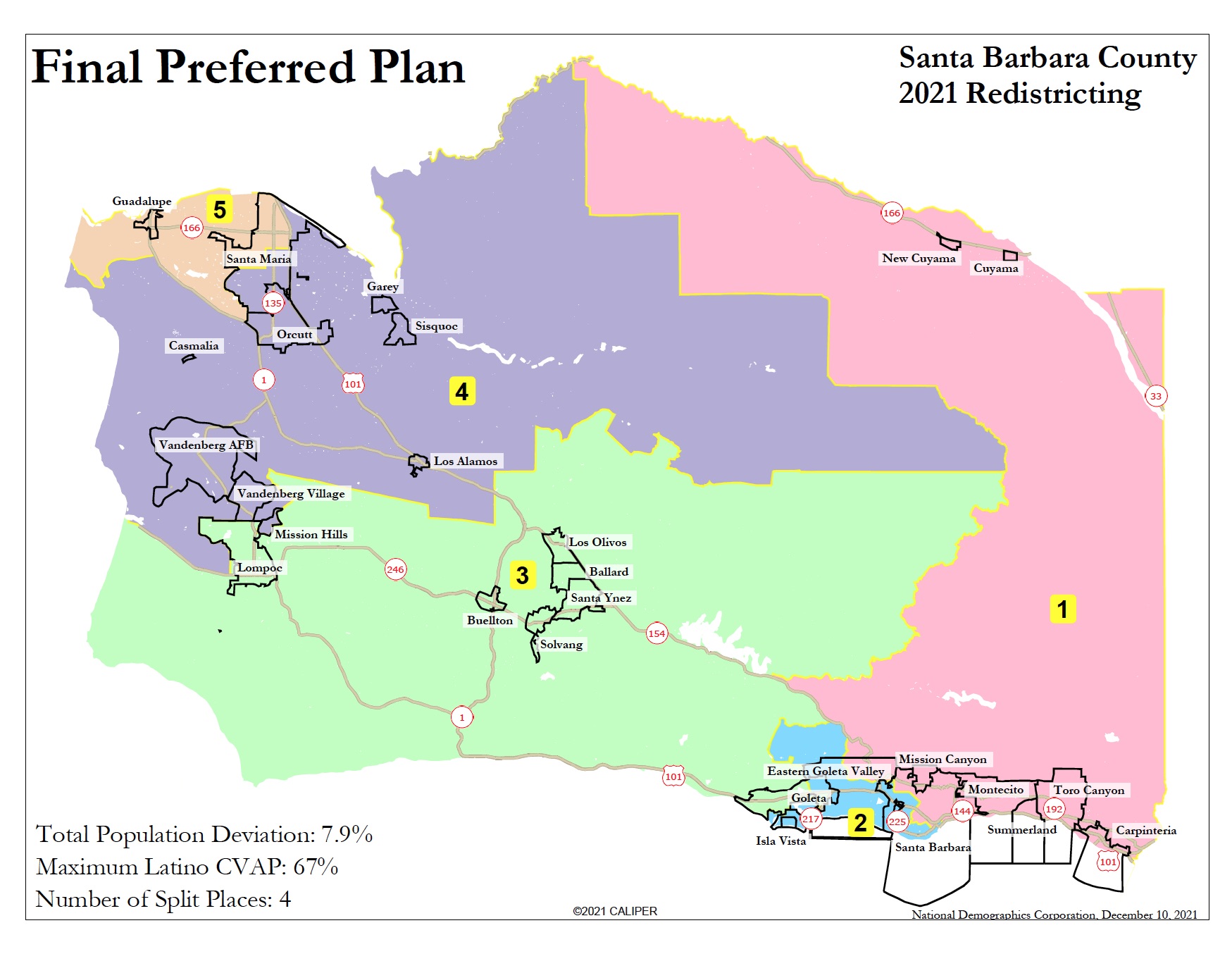
After 13 months of public meetings, six replacement Commissioner appointments, delays in census data, and threatened lawsuits, the CIRC was poised last night to approve the Commission’s Final Preferred Plan. The “plan” is the map which defines the boundaries of Santa Barbara County’s five supervisorial districts for the next decade.
The tradition of unexpected turns started off with a bang, as At-Large Commissioner Jannet Rios, who is from Santa Maria, asked to change the boundaries on the eastern side of the district to reconnect key areas of downtown Santa Maria to the rest of the City. Backed by Commission Chair Glenn Morris, also from Santa Maria, the proposed change involved a swap, moving neighborhoods east of Hwy 101 into the adjacent 4th District, and other neighborhoods that are currently in District 5 back into that district with the 101 as the eastern dividing line. This area includes Town Center East and West, City Hall, the Public Library, the Transit Center, and Allan Hancock College.
The initial response was outrage from speakers in the room, who seemed to think the proposal was a ploy to reopen the final plan to other changes (including the return of Isla Vista to the 3rd District, which they violently oppose). Given that the proposal came from a Commissioner with ties to progressive organization CAUSE, and that those speaking in opposition have demonstrated conservative political leanings, this was hardly surprising. Two Commissioners, Cheryl Trosky and Michael Hartmann (also from Santa Maria) voiced objections, concerned about a move to open up the map and skeptical about the proposed changes.
It didn’t take long for that outrage to fizzle, as several high-profile speakers expressed support for the swap. After comments by Santa Maria’s mayor and a raft of other public figures, many of them political conservatives, the audience shifted to embrace the proposed change. It was adopted by a 10-1 vote, with Hartmann as the lone dissenter.
Undeterred by the drama, 2nd District Commissioner Megan Turley offered two additional changes. One was to the Eastern Goleta Valley, which at the December 4th meeting had been somewhat randomly carved into three districts in contravention of guidelines against splitting “census designated places.” Turley explains, “I received multiple, thoughtful, researched public comments from individuals who have been working very hard on the Eastern Goleta Valley Community Plan, who were caught off guard at the December 4th meeting when the lines were changed to split the unincorporated area, as all three final focus maps had kept the census designated place and its accompanying watersheds together.” This change also passed, with two dissenting votes.
Motivated by what she had learned from Cuyama residents facing critical groundwater supply issues, Turley also proposed reuniting the San Antonio Basin Water District in Los Alamos, the only split water district. But audience members and some Commissioners were clearly done with changes. The catchword of the night was “disingenuous,” as distrustful speakers echoed each other in pushing back when they felt they had been promised a final map for the night. (In fact, the agenda item for the meeting indicated discussion of ‘draft maps’ rather than simple adoption of a final map.) When the motion was called, even Turley voted against it.
Although population numbers shift only minimally with these changes from the map approved on December 4th, there is one notable difference with the revised and now truly final plan: current 5th District Supervisor Steve Lavagnino’s neighborhood was drawn back into the 5th District. This presumably came as a relief, given that he has indicated an intention to run for a 4th term in 2022.
At this point, no more changes can be made to the final plan, since the Commission faces a legal deadline of December 15. They will meet again on Monday, December 13 at 6:30 p.m., presumably to reach what might finally be an expected and predictable outcome: adoption of a truly final plan for Santa Barbara County’s five supervisorial districts.
To see the final preferred plan, visit: https://ndcresearch.maps.arcgis.com/apps/View/index.html?appid=5b153f8500ba4199a2df0ea30ac63095&extent=-121.0883,34.2783,-118.9790,35.0936
(The demographer indicated that the changes voted in on December 8 might not be posted until late Friday, December 10, to comply with the three-day publication deadline.)
The current supervisorial boundaries, which will change for the 2022 election, are in the map below:
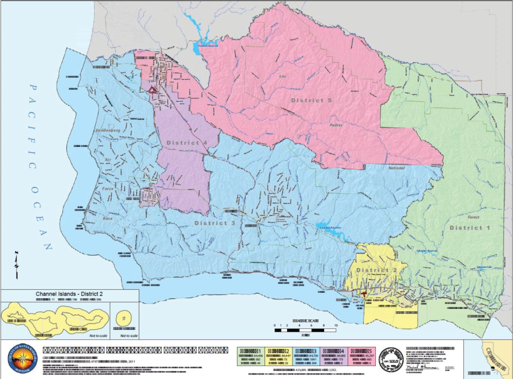
Most of District 1 remains unchanged, although the western boundary has shifted west. District 2 will now contain Isla Vista and somewhat less of Goleta. District 3 will no longer contain Isla Vista, will have more of Goleta, all of Lompoc, but not the Lompoc Valley or Guadalupe. The 4th District will have the Lompoc Valley but not Lompoc. The 5th District will consist of Guadalupe and most of Santa Maria.
Update: The new supervisorial district map decided on December 8, 2021, was added on December 10 to this piece, and the one from December 4 removed.

You must be logged in to post a comment.