[Updated: Mon., Dec. 22, 2025, 9:45pm]
With a major winter storm set to arrive during peak holiday travel, forecasters are warning that Santa Barbara County faces heightened risk of flood and debris flow. On Monday evening, the Santa Barbara County Sheriff’s Office issued an evacuation warning for properties associated with the Lake Fire burn scar area. Those properties include Midland School, Zaca Lake Resort, residences located on 9000-block of Figueroa Mountain Road (accessed through Tunnel Road), and 7401 Figueroa Mountain Road, according to an alert posted on ReadySBC.org. “The EVACUATION WARNING is in effect until further notice and may be upgraded to an Evacuation Order or a Shelter in Place Order unless there are significant changes to the weather forecast,” the alert says.
After a significant storm soaked the region last month, creeks still contain the storm’s remnants, and soils are saturated. These conditions increase the likelihood of flooding as well as infrastructure and vegetation movement as another powerful system moves in.
“We’re starting tomorrow evening with heavier rain impacting the area,” said Kristan Lund, a meteorologist with the National Weather Service Los Angeles, on Monday. “The main story is that it’s going to be pretty dangerous conditions. It’s going to be a lot of rain — very heavy rainfall — especially if any convection forms, which could include thunderstorms.”
In addition to the evacuation warning, a flood watch and high wind watch are in effect for Santa Barbara County, beginning at 4 p.m. Tuesday and currently scheduled to last through 10 p.m. Wednesday — though forecasters say that window will likely be extended.
“That means there could be flash flooding anywhere,” Lund said. “This could impact roads. We could see road closures. Streams could flood. Even some houses may have water coming in.”
While the storm is not expected to approach the scale of the 2018 Montecito debris flow, there is still risk of debris movement, particularly in canyons and steep terrain. “We could see rockfalls, land movement in any canyon — not just around burn scars,” Lund said.
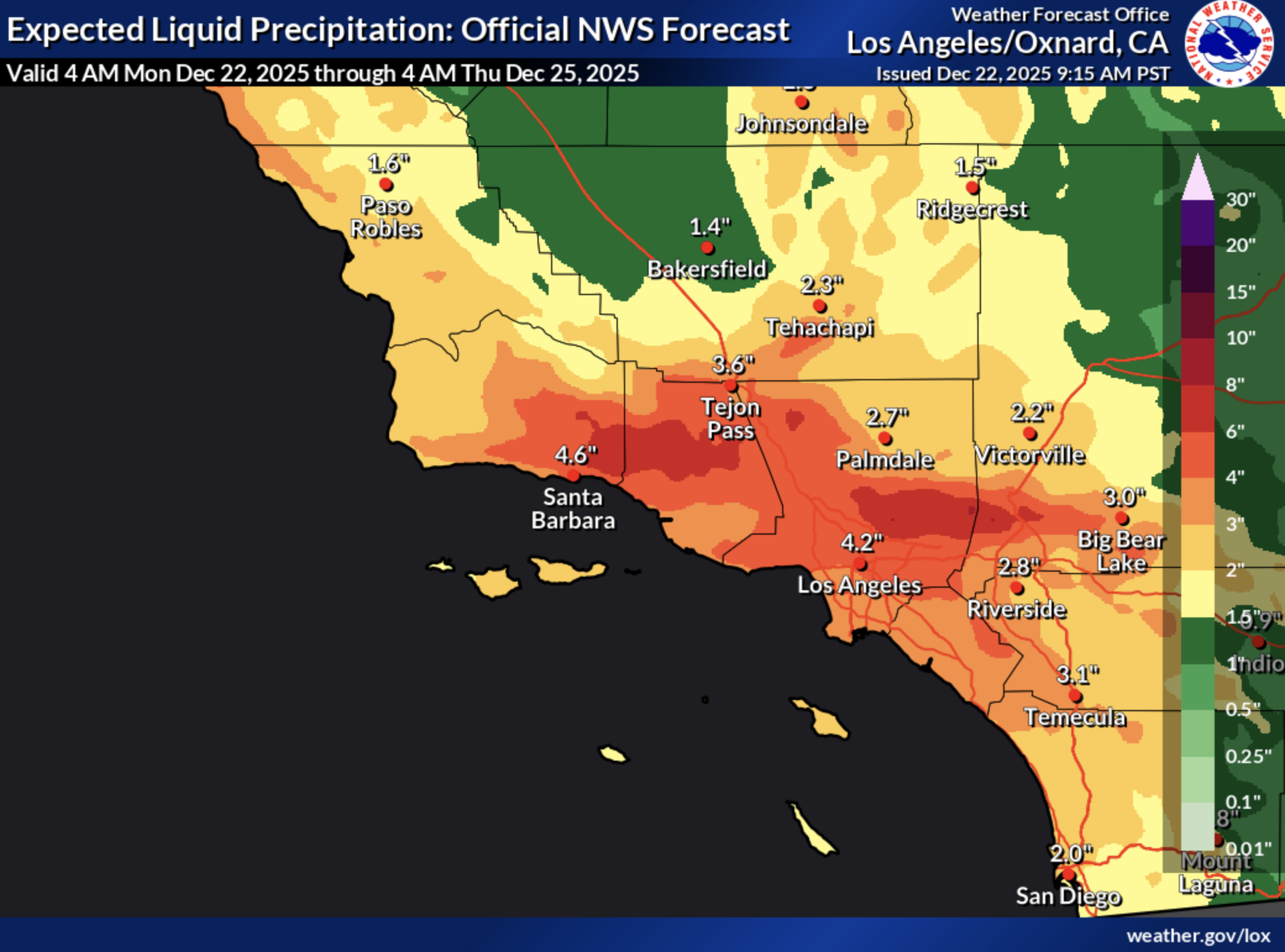
The storm is forecast to intensify Tuesday night and persist through Christmas Day, with multiple pulses of heavy rain and gusty winds. According to the National Weather Service, rainfall totals could reach 4 to 8 inches along the coast and valleys, with 6 to 12 inches in the foothills and mountains over the course of the storm.
“That’s a lot of rain in about four days,” Lund said.
Peak rainfall rates could exceed half an inch per hour, and gusts may reach 40 miles per hour Tuesday night into Wednesday. “Power outages are possible, especially with the wet soils and potential downed trees,” Lund said.
Santa Barbara County officials on Monday urged residents to prepare now and avoid unnecessary travel during the storm. “Evacuations are NOT being issued at this time,” the county stated. “If you are concerned that this storm may cause unsafe conditions to your home, leave the area before rain starts. Do not wait for an official evacuation notification to leave.”
The City of Santa Barbara is also activating free emergency storm parking, allowing residents in flood-prone areas to temporarily park vehicles in City Lot 2 (914 Chapala Street) from Monday-Friday, December 22-26. Vehicles must be registered online to receive parking validation, and camping is not permitted.
Forecasters urged residents — especially those traveling for the holidays — to stay informed and cautious.
“This is going to be a pretty dangerous situation, especially on those low-lying and hazardous roads,” Lund said. “It’s holiday travel, and people might not know the area very well. Really be cautious. Make sure your phone’s charged. Make sure you’re getting alerts.”
The storm is expected to gradually taper off Friday, though scattered showers may linger into the weekend.
Residents are encouraged to sign up for ReadySBC alerts, monitor forecasts from the National Weather Service, and avoid rivers, creeks, beach bluffs, and flooded roadways.
As officials stressed repeatedly: Turn around, don’t drown.
Santa Barbara County maintains a list of sandbag stations, road closure updates, and emergency alerts at ReadySBC.org.
Key Resources:
County Storm Readiness Info: readysbc.org/StormReadiness
Caltrans Highway Conditions: roads.dot.ca.gov/roadscell.php
County Road Closures: countyofsb.org/2116/Road-Closures
Sandbag Pickup Locations: countyofsb.org/2219/Sandbags
Emergency Alerts: bit.ly/ReadySBCAlerts
For sheltering assistance, please call the American Red Cross at (805) 678-3073.