
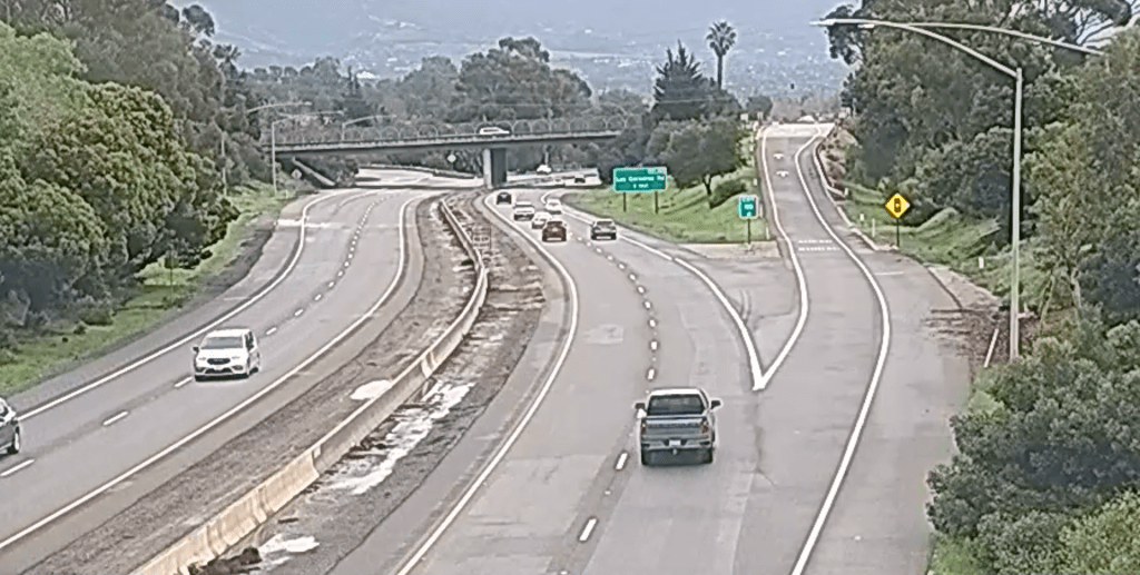
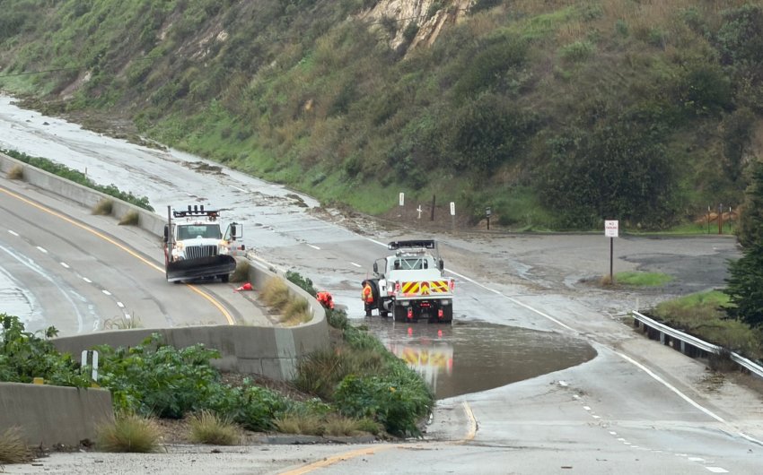
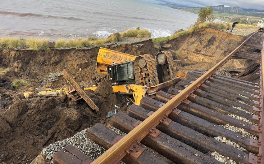
[Update: Sun., Jan. 4, 2026, 9:50am] Traffic is flowing once again along both sides of Highway 101 following a full-day closure caused by yesterday’s rainstorm. The closure began around 10 a.m. on Saturday when heavy rains triggered multiple debris flows and flooding west of Goleta that made the freeway impassable in both directions. As of Saturday evening, the southbound lane had only partially reopened, and the northbound remained closed with no estimate on when it might reopen. Crews worked through the night to clear debris along the freeway, and at around 7:30 a.m. on Sunday, Caltrans announced that the left northbound lane and both southbound lanes of the 101 near Goleta are now open. Crews will remain active today on reopening the remaining northbound lane, with work estimated to be completed by 4 p.m. on Sunday, according to a 9:44 a.m. update on Caltrans’ QuickMap.
[Original Story] Heavy rain Saturday morning prompted flash flood warnings across southern Santa Barbara County, including Goleta, Lompoc, Santa Barbara, Isla Vista, and Carpinteria, as well as the closure of multiple roadways, including Highway 101 near Goleta, due to flooding and debris flow. As of Saturday evening, the southbound 101 had partially reopened while the northbound side remained indefinitely closed.
A flash flood warning means that flash flooding is occurring or imminent, according to an alert from ReadySBC. “A flash flood is an extremely dangerous, sudden, violent, and fast-moving wall of water. Avoid recent burn areas, low-lying areas, areas with standing water, and areas near creeks or streams. If you are in one of these areas, go to the innermost room of your home or to higher ground, such as a second floor.”
The National Weather Service’s first warning, which was issued at around 9 a.m., remains in effect through noon Saturday and also covers Santa Ynez, Point Conception, Refugio State Beach, El Capitan State Beach, Buellton, and parts of Highway 154. In a post on X, the NWS warned, “Ample road flooding likely, including highway 101. Avoid driving through this area. Stay away from small creeks and canyons as heavy flows will soon develop.”
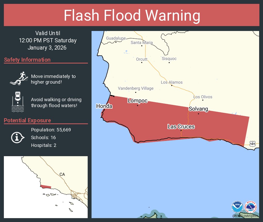
The National Weather Service issued a flash flood warning for Solvang, Buellton, Lompoc, and the Gaviota Coast on Saturday morning due to heavy rain. The warning remains in effect until Saturday at noon. | Credit: NWS 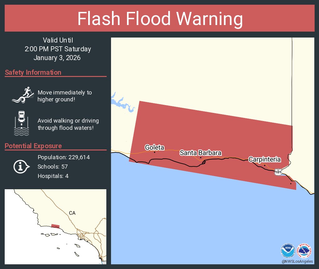
The National Weather Service issued a subsequent flash flood warning for Carpinteria, Santa Barbara, and Isla Vista that remains in effect until Saturday at 2 p.m. | Credit: NWS
A subsequent flash flood warning was issued for Carpinteria, Santa Barbara, Isla Vista, and Goleta shortly before 11 a.m. and remains in effect until 2 p.m. Saturday.
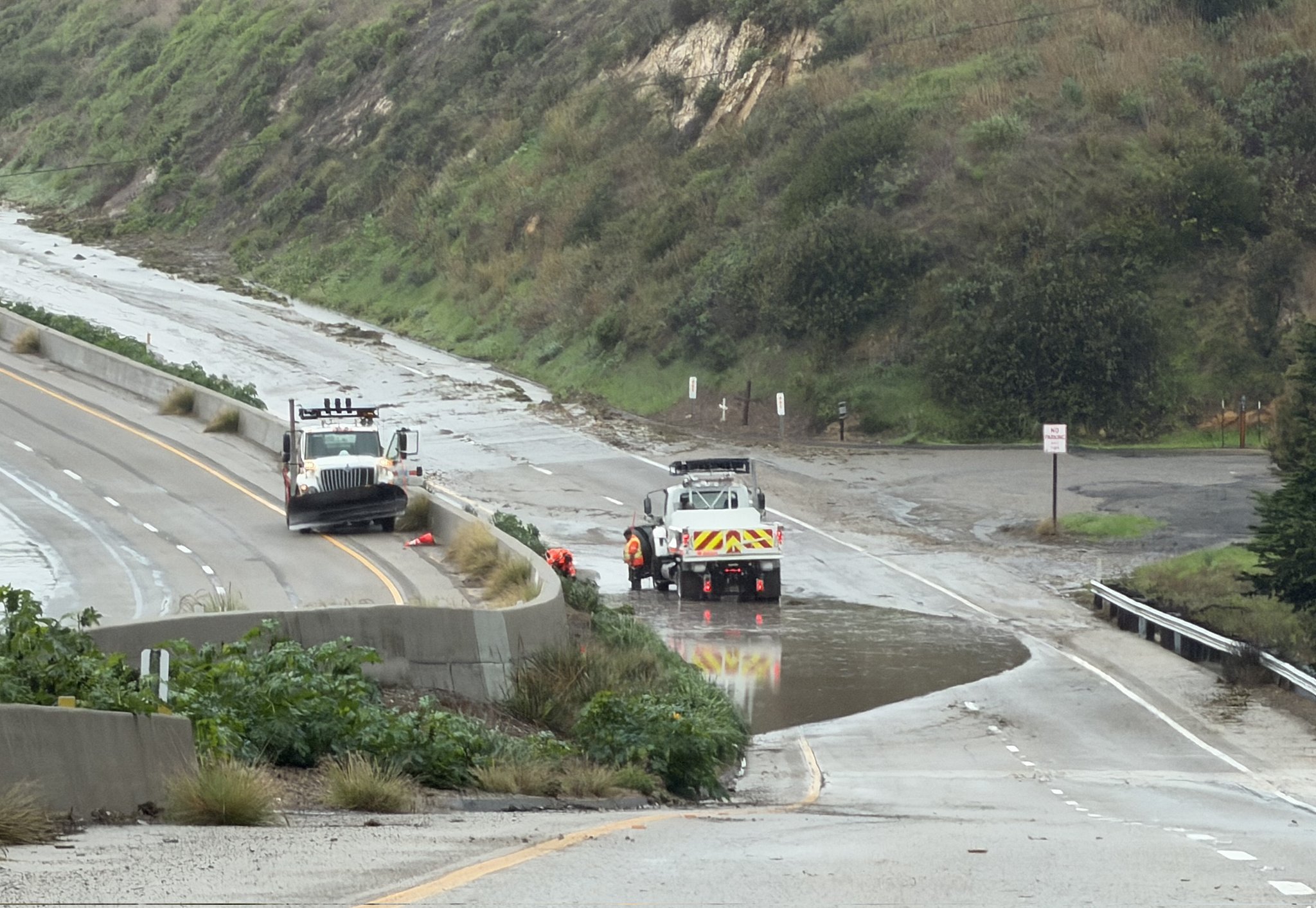
Shortly after 10 a.m., the California Highway Patrol announced on X that Highway 101 was closed from Winchester in Goleta to State Route 1 “due to debris flow and flooding for an unknown duration.” CHP advises motorists to use Highway 154 as an alternate route and to drive slow and travel safe, warning that conditions may change rapidly.
In its own post at 10:35 a.m., Caltrans clarified that Highway 101 is closed in both directions due to what it describes as “a series of mudslides” near Goleta. Caltrans crews are on site and directing southbound travelers on the 101 off at the junction with Hwy. 1 north of Gaviota, while northbound travelers are being directed off at Winchester. “No estimate for reopening,” Caltrans said.
In a followup post at 11:57 a.m., CHP said that “Caltrans crews are working diligently to reopen the freeway” but gave no estimate on when the freeway might reopen.

Shortly before 5 p.m., Caltrans posted an update on the status of the 101 closure: “Southbound US 101 has reopened to one lane for five miles from Mariposa Reina south of Gaviota to the Vista Point. Southbound US 101 is fully reopened to two lanes from south of the Vista Point. Still no estimate on reopening the northbound lanes of US 101.”
Highway 1 near Orcutt was also closed in both directions due to flooding between Solomon Road and Black Road, according to Caltrans. As of 10 a.m., there was no estimate for reopening.
In the foothills above Santa Barbara, Highway 192 was closed in both directions between Mission Canyon Road and Mountain Drive due to rockslide as of 1:30 p.m., according to Caltrans, which said there was no estimate on reopening.
Highway 135 was closed for approximately eight miles due to flooding, from one mile north of Los Alamos to the intersection with Harris Grade, according to a Caltrans post on X at 2:30 p.m.
On Highway 154, CHP reported at around 1:30 p.m. that boulders were blocking the westbound lanes at Whitakers Curve and that a Caltrans crew was en route to the scene.
In addition to the highway closures, CHP was reporting flooding at the Los Carneros Road onramp on the northbound side of Highway 101, which was first reported around 10:40 a.m.; at around 2:30 p.m., CHP was reporting mud across all lanes of the onramp.
CHP also reported that Refugio Road just north of Calle Real was “completely flooded” and that a vehicle had become “caught between floods” there. CHP said it had made contact with the reporting party, who was safe but stuck. As of 11:45 a.m., CHP was unable to reach them due to major debris on the roadway that “will need a lot of equipment” to clear.
Several vehicles were also reportedly stuck in flooding at Hollister and Fairview avenues as of 12:40 p.m., according to CHP, requiring traffic control there as well as at Cathedral Oaks at northbound San Marcos Drive. Further up San Marcos Drive, large rocks and debris is blocking all lanes at Twinridge Road, according to CHP.
In Montecito, CHP reported shortly before 3 p.m. that a fallen tree was blocking the entire roadway on the 300 block of Hot Springs Road.
Flooding was also impacting roadways in the City of Santa Barbara on Saturday. At 12:17 p.m., Santa Barbara Police Department issued a Nixel warning advising motorists to avoid the following intersections due to flooding: San Andres at Canon Perdido Street, the 00 block Calle Cesar Chavez Street, and Shoreline Drive between Castillo and Loma Alta.
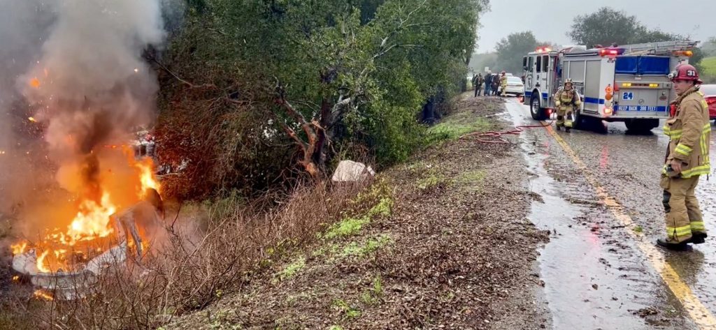
Multiple collisions have been reported during Saturday’s downpour. On the southbound Highway 101 north of Highway 154, a single vehicle went off the roadway, crashed into a tree, and was engulfed in flames, according to a Santa Barbara County Fire post on X at 12:20 p.m. All three occupants of the vehicle were extricated from the vehicle and transported by ambulance to Marian Regional Medical Center, with one patient critically injured and the other two suffering from minor to moderate injuries. As a result of the crash, CHP was controlling southbound traffic down to one lane, according to County Fire. The cause of the crash remains under investigation.
At 11:55 a.m., CHP reported a single-vehicle, non-injury crash on the southbound 101 north of Patterson Avenue. Then at around 12:13 a.m., a black Tesla and white sedan were reportedly involved in a collision and came to a stop in center divider of the southbound 101 just north of Garden Street. According to CHP, the crash resulted in airbags being deployed in both vehicles, requiring an ambulance to be called for the occupant of the Tesla, though it was unclear what the extent of the injuries were.
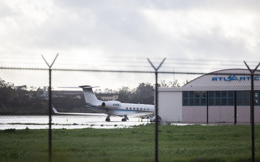
Saturday’s storm also grounded all flights at Santa Barbara Airport, which announced this afternoon it was temporarily closed due to flooding on its runway.
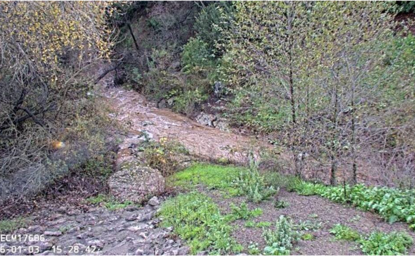
According to the county’s real-time rainfall data, the Gaviota Coast received more than 3.3 inches of rain in the three hours between 9:15 a.m. and 12:15 p.m. On Friday, forecasters anticipated rain totals through Monday could reach two to three inches in coastal areas, and between four and six inches in the foothills and mountains. Rain is expected to taper to off-and-on showers through Sunday and into early next week.
Resources
- Detailed National Weather Service forecasts: https://www.weather.gov/lox/
- Real-time Rainfall, River-Stream, & Reservoir Information: https://rain.cosbpw.net/
- Storm readiness tips: http://www.readysbc.org/StormReadiness
- For status of highways: https://roads.dot.ca.gov/roadscell.php
- For status of County roadways: https://www.countyofsb.org/2116/Road-Closures
- For countywide sandbag filling locations: https://www.countyofsb.org/2219/Sandbags
- Sign up for ReadySBC Emergency Alerts: https://member.everbridge.net/index/892807736723794#/signup


You must be logged in to post a comment.