[Update: Thu., Aug. 7, 2025, 12:55pm] As of Thursday afternoon, the Gifford Fire has grown to 96,106 acres and is 15 percent contained, according to InciniWeb.
“Overnight winds exceeding 30 mph for over an hour pushed the fire toward Huasna and Willis Ranch, with active spread between Pine Ridge and Haystack Canyon,” according to Thursday morning update from incident command. “This prompted new evacuation orders west of those areas in San Luis Obispo County. The rest of the fire area saw minimal activity last night.
“Today, the priority focus area for crews to construct control lines will be west of Pine Ridge and Haystack Canyon taking advantage of anticipated northwesterly winds,” the status report continues. “On the north end, crews continue direct attack along Avenales Ranch Road and scout contingency lines further north. A UAS flight on the south end identified heat spots for crews to target today. Crews also added containment on the east and west flanks and will monitor for interior smokes and heat.”
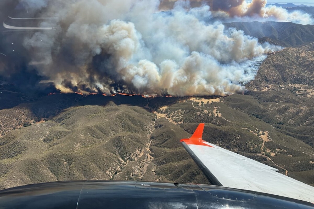
[Original Story] The Gifford Fire, blazing about 15 miles northeast of Santa Maria since Friday, August 1, is now California’s largest fire of 2025 and without support from the weather, likely to grow even larger. Hundreds more firefighters respond daily from multiple agencies, working amid smoky, erratic fire behavior toward what is now 9 percent containment of a fire chewing across rough terrain that may not have burned since 1953’s Big Dalton Fire. Dozens of engines, dozers, and water tenders, and 11 helicopters are onsite, with fixed-wing aircraft available on call.
The growth of the fire has been explosive: from 10 acres on Friday to 30,000 on Saturday and 65,000 on Sunday. Captain Scott Safechuck of Santa Barbara County Fire described how smoke columns rising from the heat could blast embers outward at erratic intervals: “The whiter, more distinct area at the top is where the plume reaches an altitude where the smoke column develops an ice cap. When that collapses to the ground, it pushes the fire in a lot of directions, which is why we saw the fire go from 39,000 acres to 65,000 acres in a day.”
“It helps to have legs like a mountain goat and be in superior condition to work in this unforgivingly steep country,” said Flemming Bertelsen, information officer for Los Padres National Forest. The very old growth brush dulls chainsaws quickly, he said, and the hot shot crews must stop frequently to sharpen their tools. Burning across the dry terrain to the south and north of State Route 166, the fire’s growth to 83,933 acres by Wednesday morning is helped by the cross-hatching of ridges and drainages that present fresh fuel to any direction the wind blows.
Incident Command’s goal on Wednesday was to build containment lines on the northwest side to hold back the head of the fire, which had crossed the electrical transmission corridor. That zone, as well as communications facilities on La Panza Peak to the northeast of the fire, and at Plowshare Peak to the south, had been brush cut by fire crews and hit with fire retardant by aircraft, Bertelsen said: “Both survived.” In addition to the fire crew camp in Santa Maria, two new base camps were set up closer to the fire to the east and north on Tuesday, with a potential for a third at New Cuyama.
About 5 percent of the San Rafael Wilderness was on fire, Bertelsen said, on the east side of the fire. “The tricky thing about fire in the wilderness is the absence of firebreaks and roads. There’s no pre-existing control lines, so the fire tends to get bigger in these areas.” He explained that it took an act of Congress to get approval for the use of mechanized equipment, including chainsaws, in a wilderness area of old-growth timber, though approval happened quickly if a fire became critical, which the Gifford so far has not.
No firefighters have been injured among the 2,323 on duty, but two contractors were injured in a rollover accident and one motorist along the 166 suffered burns when they left their car to view the fire on the day it ignited. As of Tuesday, 520 people had been evacuated, said Bertelsen. Another 302 were under an evacuation warning, said Lieutenant Jarrett Morris of the Sheriff’s Office. More than 1,200 structures were threatened, including more than 100 homes in the rural Huasna Valley. Mandatory evacuation orders now reach to the Sisquoc River and evacuation warnings to Foxen Canyon Road. Visit ReadySBC.org for full information or to sign up to receive emergency alerts.
Weather reports offer no respite to firefighters on the line, where heat stress can be an issue. A heat wave is expected to raise temperatures into the 100s this week and wind gusts of up to 20-25mph will continue to fan the flames.
The Big Dalton is by no means the only historic fire in this area. County Fire’s History Dashboard depicts a multitude of fires, including 1997’s Logan Fire to the north and 2009’s La Brea fire in the south of Gifford.
Notably the Zaca Fire, which started on the Fourth of July in 2007, burned for 62 days. Flaring across the backcountry surrounding the Santa Ynez River watershed, Zaca started a month earlier than Gifford’s heat-of-the-summer ignition point. After Zaca burned 240,000 acres, the winter rains sent slurries of sediment and three inches of ash into Cachuma Lake, an increase in organics that the South County water agencies had to neutralize.
Gifford’s cloud of smoke is causing air quality alerts in the Cuyama Valley, and warnings for particulate matter from Santa Maria to Carpinteria. If you smell smoke or see falling ash, minimize outdoor exercise and stay indoors, the Air Pollution Control District advises.
A community update by Gifford Fire officials takes place Wednesday evening in New Cuyama at the recreation center (4885 Primero St.), at 7 p.m.