Death Toll Approaches 23 in the Worst Disaster in Santa Barbara History
Tracing the History and Coping with the Reality of 20 Lost and Three Still Missing

Sometimes words fail.
The scientific term is “debris flow.” Commonly we call it a “mudslide.” Neither comes close to conveying the awesome geologic violence wrought upon Montecito and the entire South Coast early on January 9.
Hurricanes, tornadoes, and fires all have first names. Katrina. Harvey. Irma. And most recently, our very own Thomas, now the biggest fire in state history. By contrast, the monster that just turned our community upside down has no name, first, last, or otherwise.
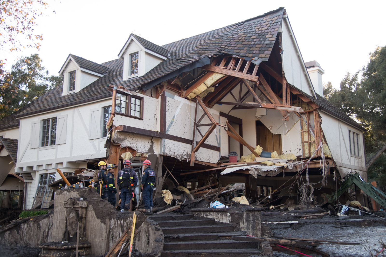
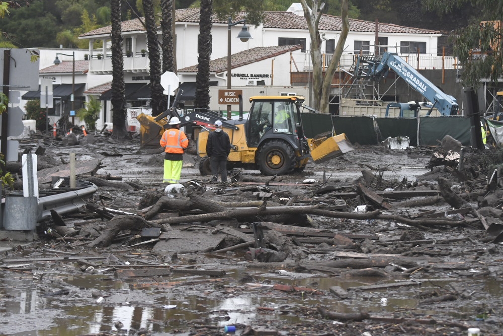
As of this writing, Santa Barbara has officially abandoned hope of finding more survivors. But the truly intrepid rescue teams, with their amazing search dogs, continue working to unbury the missing. Should the grim arithmetic be borne out, the death toll for the event with no name will reach 23. It could well go higher. In the meantime, official documents set the mortality count at 20. Add to this the 127 single-family homes that were destroyed and the 294 that were damaged.
By Santa Barbara standards, this ranks as our worst catastrophe — natural or otherwise — ever. The great earthquake of 1925 — still the single most transformative event to hit Santa Barbara in the past 200 years — claimed the lives of 13 people. Psychopaths such as David Attias in 2001, Jennifer San Marco in 2006, and Elliott Rodger in 2014 killed four, seven, and six on their respective rampages. The 1923 disaster at Honda Point ties as the county’s worst, claiming the lives of 23 sailors when seven Navy ships out of San Francisco ran aground on what is now known as Destroyer Rock.
When it comes to collective grief, we are in uncharted territory.
Rage, inevitably, is right around the corner.
Santa Barbara, as some like to say, lies perched on the edge of nature. Last week, nature pushed us off. The storm event began in earnest early Tuesday morning around 3:30. For about half an hour, lacerating rains slashed away the steep hillsides. Only two weeks before, the Thomas Fire had roiled through those same hills. Firefighters had mounted a heroic defense, miraculously protecting most of Montecito. With only 27 single-family homes destroyed in Santa Barbara County, the thousands of evacuated residents breathed a sigh of relief, thinking they had dodged a bullet. But the greatest horror lay waiting in the dirt itself.
High-intensity heat from fires such as Thomas slowly cooks the top few inches of soil, turning it into a fine, crumbly powder. Any roots that once kept the top mantle of soil intact have been blowtorched into oblivion. Flood-control experts, who refer to this condition as “dry creep,” swear they can hear it sloughing its way down the mountain.
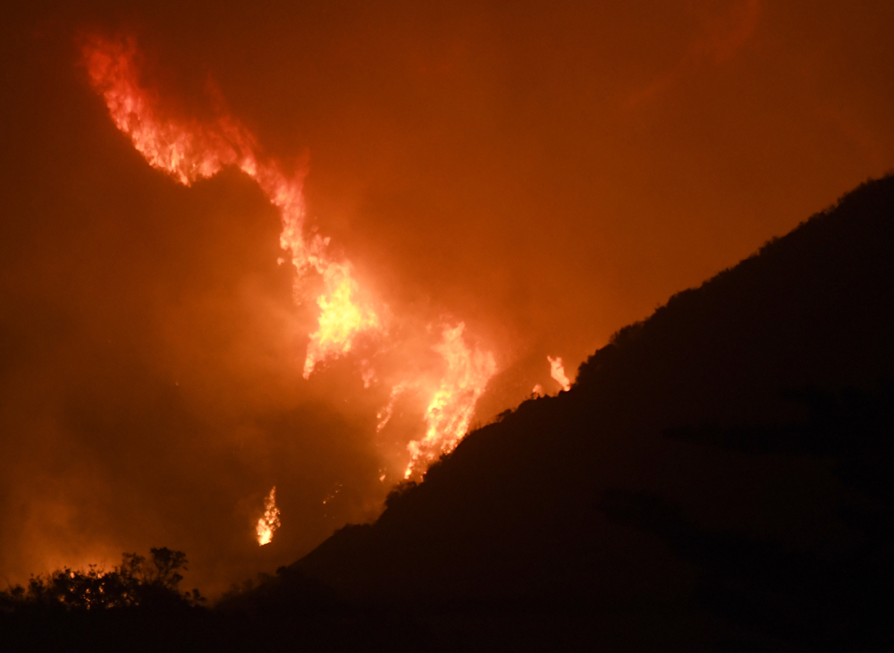
Add to that the gnarled canopy of chaparral covering Santa Barbara’s backcountry, and the picture gets more ominous. Chaparral plants contain waxy compounds that, when heated, ooze out onto the soil as liquid paraffin. This waxy shell in turn deflects raindrops that might otherwise be absorbed by the soil.
Now turn up the volume to 11.
Imagine the longest drought in Santa Barbara history, followed by the biggest natural fire in California history. Then, while that fire is still smoldering, watch a late-night winter rainstorm dive-bombing the scorched earth with four times more impact than the direst forecasts. Meteorologists were freaking out when predicting Tuesday’s rains, which they feared might deliver as much as one to two inches an hour. It turns out they didn’t freak out enough. In some places, we got half an inch of water in five minutes.
Hence the disaster with no name.
Torrential rivers of dirt, silt, and ash careened down the steep hillsides, racing toward the meandering creek basins that make Montecito such a bucolic paradise. Along the way, it gathered more steam, sucking up and vomiting out much of the burned rubble from the fire: trees, logs, gravel, rocks, and boulders the size of tour buses. This blackened slurry creates a seemingly impossible buoyancy that allows even the most massive rocks to float. It also rushes by faster than humans can bring themselves to believe.
Last week’s debris flow was hardly Santa Barbara’s first. Jim Stubchaer, then an engineer with County Flood Control, remembers the avalanche of mud that took 250 homes back in November 1964 when heavy rains followed quickly on the heels of the Coyote Fire. He was there in 1969 and 1971 when it happened again. “We had a saying back in the day for those canyons,” said Stubchaer about Santa Barbara’s steep mountain slopes. “We said they were shotguns, loaded with rocks and set off by fire.”
Indeed.
Disaster response efforts were in place well before the sky began to fall in the predawn hours on January 9. The night before, teams of firefighters — engines and strike teams from multiple agencies — and about 200 first responders were positioned throughout Montecito and Carpinteria in anticipation of flash floods. All fire stations were put on alert. A multiagency incident command was created for an incident that had yet to happen.
Three days before the onslaught, all the usual suspects in the world of emergency responders convened in front of television cameras. They predicted flash floods 10 times worse than normal because of the fire-scarred hillsides. Supervisor Das Williams intoned the term “clear and present danger.” Mandatory evacuation orders were announced for 7,000 people living in the foothills upslope from Highway 192, effective Monday at noon. Another 23,000 people — living downslope from Highway 192 — were put on warning.
Nobody screamed or shouted. Maybe they should have.
In the end, only 15 percent of those living in the mandatory evacuation zone got out. That’s considerably more, however, than those who lived in the warning zone. How these zones were mapped — and why the evacuation zones were not drawn to adhere to the downstream flow of creek channels rather than the geographically irrelevant Highway 192 — will be the subject of intense discussion and, in all probability, litigation in the months to come.

Firefighters, emergency planners, law enforcement officers, and other first responders — traumatized from risking life and limb; working long, harrowing hours; and pulling dead bodies out of the muck — bristle at the suggestion they didn’t do everything possible. Emails, texts, emergency alerts, and phone calls were made. Doors were knocked on. Homeless camps along creek bottoms were rousted. What else could they do?
Beverley Jackson, an imposing Montecito doyenne and longtime society columnist for the Santa Barbara News-Press and the Independent, recalled getting the knock and refusing to budge. “I had just got back from spending eight days in a motel because of the Thomas Fire,” she said. “I didn’t want to be evacuated again. I have a dog. And I felt very comfortable there.” Jackson added she’d been through multiple floods and fires during her time in Montecito. “At 89, I wanted to prove I could do it,” she said. “I’m not going to age gracefully.”
However, there are also residents living in the warning zone who felt that they’d been given a false sense of security. Many — old hands now at the evacuation drill — had their bags packed and cars loaded when the storm hit. But by the time county emergency alerts went out, it was too late. They couldn’t get out. Or as one longtime emergency-planning expert put it, “Of course people are going to be stupid. Our job is to work around them, not blame them.”

The dance of droughts, fires, and floods is ancient and endemic to Southern California’s landscape. It’s how creeks change course and mountains move. But as California’s extreme weather gyrations grow ever more extreme, pushed no doubt by climate change and global warming, new emergency response strategies will be needed. Abe Powell, a member of the Montecito Fire board and one of Montecito’s most active public citizens, noted that this was the first time a flood event — as opposed to fires — was occasion for an organized evacuation effort.
As South Coast emergency planners re-engineer ways to warn — and mobilize — area residents about future disasters, Montecito and Santa Barbara face the more immediate challenges of digging their way out of this one. Highway 101, we are told, won’t be open for yet another week. In the meantime, about 15,000 people who live in Ventura and work in Santa Barbara can’t get to their jobs. Cottage Hospital is reportedly putting up about 200 workers in local hotels and motels, flying some in and transporting others by boat. Many Santa Barbara companies depend on out-of-town workers. The Montecito Water District is facing multiple breaks to its primary mains used to get water from its reservoirs to storage basins. At this point, about half its customers can get no water at all; another half can get some but just barely. In this grim context, the good news is that things could be even worse but aren’t. The main conduit connecting Montecito customers to water from Lake Cachuma is not broken, as first thought. Dozens of workers from other water agencies — near and far — have chipped in to help Montecito staff locate and assess damages. In the meantime, however, the district was the target of the first lawsuit filed in the wake of last week’s catastrophe, charging that the nine million gallons that leaked out of one of Montecito’s storage reservoirs made a bad situation that much worse.
In the meantime, Santa Barbarans are responding to disaster the way they always do: with massive outpourings of community support. As can be expected, there’s been some grandstanding by a few self-serving publicity hounds. But mostly, community residents are striving for ways to chip in and help out.
In the years to come, January 9, 2018, will be considered the measuring stick by which all subsequent disasters will be compared. Future generations can only pray they don’t measure up.
Editor’s Note: This story added on January 19 information on the Honda Point incident.