
Forest Closure to be Reduced
Some parts of the forest will be re-opened for recreation but much of it will stay closed

Though it will be good news to those who want to get back out into Los Padres Forest, many will be disappointed at how little access will be allowed. What has been a summer-long closure of most of the Santa Barbara backcountry may extend thoughout the winter.
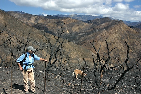
For those Santa Barbara residents itching to head out into the wilderness areas to see the impacts of the Zaca Fire up close, most likely this won’t happen for quite a while. Damage to the trails could be extensive, even without the impact that a heavy winter could bring. On a recent trip into upper Santa Cruz Creek with acting Santa Barbara District Ranger Cindy Chojnacky (pronounced “chi-naw-sky”) and Wilderness Ranger Kery Kellogg we were overwhelmed by the the trail conditions; with no vegetative cover above the trail, debris continues to slide down onto it.
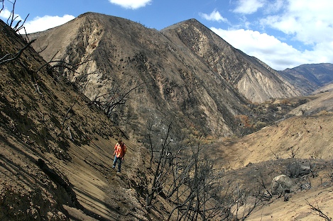
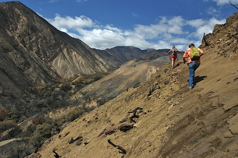
“After the first big storm, we may not even have a trail,” Kellogg explained as we worked our way up sections of it near Flores Flats. Two of the Volunteer Wilderness Rangers (VWR) who braved the hike down from Little Pine to Santa Cruz Guard Station were in full agreement. “There were sections where I had no idea where the tread was,” Jasonn Beckstrand told me. “I was using my hand tools to anchor myself so I wouldn’t slide down the hill.”
“We started to clear water bars to help with erosion,” the other VWR volunteer Mike Smith added. “After the first half mile we gave up. It was difficult enough just getitng down the trail, let alone trying to get any work done.”
On October 1, the Forest Service will announce it is easing restrictions to the forest, but not to locations such as the wilderness. “The Forest Supervisor Ken Heffner has decided he doesn’t want access to the burn area for quite a while,” Chojnacky said in an interview this morning. “After our trip to Santa Cruz it is easy to see why. It’s really dangerous out there and it will be more so this winter.”
Though I haven’t seen the final closure map yet, it appears the Forest Service is taking what might be termed a “day use” approach, re-opening edges of the forest to use but for day time use only. Figueroa Mountain Road will be opened but there will be closed gates at the Zaca Jeepway and Cachuma Saddle. The road down to Nira will be open but you’ll need to walk or bike ride in to get there. Hiking trails on the back side of Figueroa Mountain will more than likely be open as well.
In the Santa Barbara Ranger District it appears access to the lower Santa Ynez Recreation area will be opened up to day use and all of the trails on the back side of the Santa Ynez Mountains will be available as well. Mountain bikers who use the Snyder Trail will appreciate this. However they won’t appreciate knowing that Little PIne Mountain will be off limits for now. Use of the Buckhorn Road will be limited to the intersection of Camuesa Road and along Camuesa Raod into the upper Santa Ynez River area.
OHV enthusiasts will cheer the opening of the Divide Peak route but you should also know that the route up from Upper Oso towards Little Pine Mountain will be closed for the season. “There is just too many places where vehicles can get off the road,” Chojnacky explained. “We’re trying to provide as much access as we can but we also need to protect the resources.”
Of the 240,000 acres burned in the Zaca Fire, satellite imagery has been used to estimate the percentages of the areas that were burned severely, moderately and lightly. Severe fire damage basically means that virtually all vegetation is gone. Preliminary results from the images suggest that more than 13,000 acres in the Mono and Indian Creek drainages were severely burned alone. That’s more than 20 square miles of country that will have nothing to hold back the loose soils once the rain begins to fall.
Over the next several months I’ll be providing regular updates on the post-fire side of the story. For two months many of us were riveted by the the fire stories. The drama was real; intensely so as it edged nearer and nearer to Santa Barbara. Though the flames have gone out, the story is not yet over and may not be for years to come.


