Alder Creek Camp and the Upper Franklin Trail
A Tiny and Quaint Wilderness Locale Behind Carpinteria
Hike: Bike and hike to Alder Creek Camp; suitable for fit children ages 11 and above
Mileage: 10-mile roundtrip, with seven spent biking along scenic Juncal Road
Time: About six hours round-trip, not including the 80-minute drive to shuttered Juncal Camp on the upper Santa Ynez River
Maps: Craig Carey’sHiking and Backpacking Santa Barbara and Ventura has this as Route 16 “Upper Franklin Trail” (pp. 88 – 91) and Map 5.
I had been dreaming about getting out to nearby backcountry at Alder Creek Camp for months because it’s a fantastic hike/bike combination. Yes, the 10-mile round-trip with considerable dirt road biking scared off most potential hiking partners, but not teaching colleague Chris Caretto. In the third year of our drought, I also wanted to discover if Alder Creek is still flowing and pouring into Jameson Lake through the weird little aqueduct.
Alder Creek Camp — not the better-known site in Ventura County — is a tiny and quaint wilderness locale buried on the backside of the low coastal range right behind Carpinteria. There is no table there, hardly a flat spot for one tent, simply an artful stone circle in which to lay a campfire.
Driving my truck loaded with two bikes the 23 miles from Santa Barbara’s Westside to the parking spot at now-shuttered Juncal Campground on the upper Santa Ynez River required about 90 minutes — I used my old Ford Ranger’s four-wheel drive, and the dirt portion of Romero-Camuesa Road heading down to the river was rough with some nasty washboard sections.
Immediately after fording the Santa Ynez in the truck, we spied a locked gate and on the right side an ideal parking spot for one or two vehicles. You begin the 3.5 mile Juncal Road biking portion right here, and as we pedaled quietly through the campground that morning, the chill temperatures chafed facial skin and hammered the fingers despite gloves and plenty of warm gear: 37°F at7:30 a.m. The feds closed Juncal Campground in 2000 in order to protect the threatened arroyo toad. Amazed that the tiny upper Santa Ynez River was still flowing, we still couldn’t see or hear any of the prized toads.
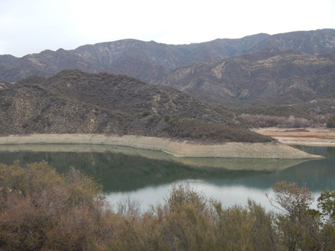
After some mostly flat cycling with a bit of up, we hit a half-mile of very steep ascending, and in my upper middle-age lack of hubris, I happily hopped off my ancient mountain bike and pushed for about 20 minutes. Juncal Road itself exists mainly to allow the Montecito Water District to monitor picturesque Jameson Lake, one of their water-supply reservoirs, and supply the dam manager’s place.
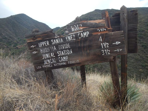
Continuing on the ride, sweaty despite the chill, we enjoy some fairly flat stretches and begin to admire Juncal Dam and Jameson Lake behind it, although the water-level is obviously very low. (Ten years ago, Montecito got 1,730 acre-feet of water from its tunnel to Jameson Lake.) With the lake on the left, we find the two roadside historic USFS signs and know this is where we’ll stash the bikes and commence the even more exhilarating stretch hiking 1.5 miles ascending to Alder Creek Camp.
The two archaic Depression-era signs are similar in size and still hang high up on their 4×4 wooden posts, one of them dangling askew. They suffer a fascinating bipolar disorder since one is entirely accurate, but the other is fairly confusing. The slanting Juncal Road sign with its disfigured and unreadable top displays factual information about sites and distances, e.g. the stunning Murietta Divide is indeed another four agonizing bicycle miles (enjoy Billiard Flats).
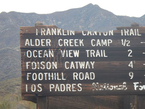
The more complex Franklin Canyon Trail sign, also damaged at the top, inscribes site names in the direction we are now going to walk — southward to the sea toward Carpinteria. However, it has errors like the fact that on this backside of the Carpinteria coastal ridge, there isn’t really a complete “Franklin Trail” as there was in 1913 when it was made. This historic trail once went over the top from Carp and down into Alder Creek and its camp, then up to Billiard Flats and the headwaters of the Santa Ynez River (see Ray Ford’s article about the wonderful reopening of a coastal portion).
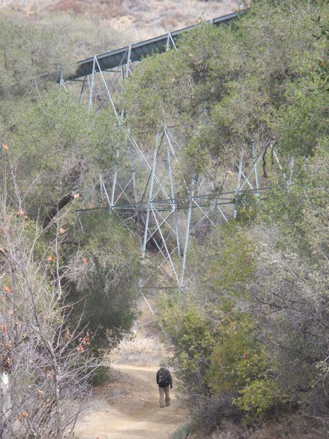
Most seriously, Alder Creek Camp isn’t the easy “½” mile you read on the sign; in fact, it morphed into a surprisingly rigorous 1.5-mile ascent into verdant Alder Creek Canyon to reach the remote campsite. We began our hike by first dropping down a bit and literally walking under the Alder Creek aqueduct, or flume. I was surprised to hear water running in it, and later as we ascended the narrowing Alder Creek Trail, I felt great joy at seeing so much water in the creek, which we paralleled as we trudged. Due to the copious water in Alder Creek we observed glorious ferns opening, smelled fragrant California bay laurel, and walked and clambered amid the abundant alders themselves.
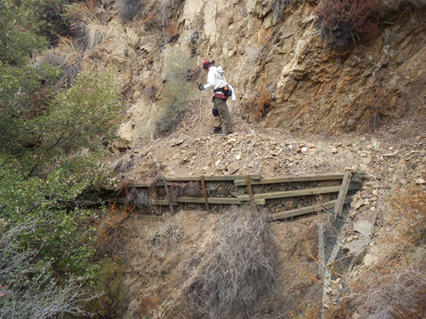
Hiking up the last half mile or so demanded our attention and reserves — there were a few scrambling places of failed trail where I was very glad for my hiking poles since some drops were over 30 feet.
Alder Camp was first established by a Carpinterian named “Dad” Ramey, and he did this in order to link up the Franklin Canyon Trail, the Juncal-Murietta Divide Trail (the road), and the tiny upper Santa Ynez Camp near Billiard Flats. Cate School horsemen would ride there for an overnight from Cate Mesa. Historically, Alder Camp was once an important rest-camp on the journey from Carpinteria over to the Murietta Divide and eventually to Matilija Canyon, Highway 33, and Ojai.
Some scholars hold that there is a “California Dream” version of our iconic American Dream myth. This corollary takes the Golden State and “cornucopia of the world” concept several steps into unconventional thinking — contemplating our wilderness West both as an inspiration, but entailing American “exceptionalism,” too.
In Trees in Paradise, A California History, author Jared Farmer wisely notes that “In no other section of America do you find such juxtapositions of cities and wilderness areas, or plantations and wildlife refuges, or farmworker poverty and agricultural wealth.” What a natural blessing for us Santa Barbarans that these glorious and remote wilderness zones are paradoxically so close and available for our explorations and reveries.