
Tea Fire Appears Close to an End
Wind Plays in Firefighters' Favor


It is just about noon and given what’s happening down in the Sylmar and Yorba Linda areas, people are getting nervous, worrying that the Santa Ana winds down south might portend a change here. Those whom I’ve talked with also worry that we’re about to lose precious resources to those fires.
“We still have seven helicopters doing water drops in the upper canyon areas,” explained Eli Iskow, spokesperson for the Santa Barbara County Fire Department. “Most of the hot spots are in the upper parts of Rattlesnake and Cold Spring Canyon, but the water drops have been extremely effective in keeping the hot spots from spreading.”

Iskow also reported that the fixed-wing aircraft have been assigned to the Southern California fires and that some of the engine crews may be leaving soon. “We don’t need the aircraft now,” Iskow explained, “but if the wind does come back up and conditions change, we’ll get them back.”
Iskow also added that some engine crews may be released soon as well. “While we aren’t at the point we can call any of the residential areas contained yet, yesterday’s calm winds allowed us secure most of the areas that were threatened. Today and tomorrow are critical. If the winds continue to stay low we could see major progress in containing the fire.”
At 11 a.m. this morning, fire officials announced some relaxation in the restrictions that residents face. All evacuation warnings have been canceled and the mandatory evacuation area has been reduced somewhat in size.

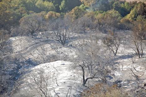
Yesterday, the view from Gibraltar Road was sobering. Much of the vegetation stretching from Cold Spring Canyon to Gibraltar Road and from Stanwood north to the ridges above Mountain Drive has been burned out completely. Above Mountain Drive, those homes that didn’t burn stand out in stark contrast to the mineral soil that surrounds them. Save a scattering of small bushes and a tree or two, most of the residences that survived the fire have a naked look to them. Why they did not burn is a mystery. Without vegetation it is difficult to know which might have survived because owners cleared their properties, made the right fire resistant changes to their homes or were just plain lucky.
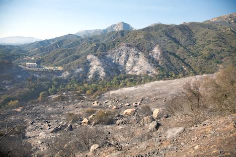
The drive up Gibraltar Road is not without difficulty. Because there is absolutely no vegetation on the hills immediately above the road, rocks of all sizes are all over it. Come winter, the erosion issues all the way up to the hairpin turn near the West Fork trailhead will be enormous.
Along Mountain Drive, the most serious damage occurred on the Cold Spring end of the burn area, closest to Westmont. At one point I met a number of people herding several horses into a trailer. Because the fire had struck so quickly, there hadn’t been time to rescue them. Fortunately the area where the horses had been stabled didn’t burn even though much of the surrounding land had. Every fire has its tragedies and thank heavens for those that end well such as this.
Much of the immediate impact of the fire was occurring below Mountain Drive. As the flames roared through Westmont, cut across Coyote Road, and then headed down Sycamore Canyon to the Riviera, the fire was also heading almost directly west from Cold Spring Road toward Mission Canyon. For the next four miles the flames rushed in a path almost parallel to Mountain Drive, burning almost everything in its path from the bottom of Coyote to the ridges above Mountain Drive.
As the fire neared Gibraltar Road, rather than continuing straight west and directly down Mountain Drive along California Highway 192, as it easily could have done, wind and topography apparently shifted the fire in a more north-westerly direction, sending the flames up over Gibraltar Road in the vicinity of Mount Calvary Retreat and racing up toward the cell towers located about halfway up the mountains.

Had the fire continued directly west, its path would have been down Highway 192 into the lower part of Mission Canyon. Instead, Mount Calvary felt the fury of the massive firestorm that passed over the crest. Within minutes the fire blew over the top of the retreat and forced its way down into Rattlesnake Canyon, around the north side of Saint Mary’s Seminary and then headed uphill toward the ridge that separates Rattlesnake from Mission Canyon.
Then, just as quickly as they had come up in early evening, the winds died down. Flames that minutes before been rushing up the ridge near St. Mary’s on their way toward upper Mission Canyon hit the top of the ridge and stopped.
For most of yesterday there were three points of emphasis: reduce the fire danger in the residential areas within the mandatory evacuation zone, keep the fire from spreading out of Rattlesnake Canyon, and contain the small spot fires in the West Fork of Cold Spring Canyon.
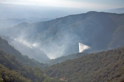
By noon when I reached St. Mary’s I could see smoke plumes rising from the middle part of the canyon in the vicinity of the pine forest near the first creek crossing along the Rattlesnake Canyon Trail. A bit further there were flames just below Tin Can Shack. While helicopters were making dozens of round trips and dropping load after load of water on the hot spots, close to a hundred hot shots were beginning to make their way up the ridge on the west side of the canyon in an attempt to tie into the power line road that leads up from the Mission Canyon side of the ridge.
An hour later, at a point along Gibraltar Road where I could look down on the canyon, I could see that most of the smoke was coming from the east side of the canyon and none of the fire appeared to have crossed the creek itself. Good news. By then it was 1 p.m. and still the winds promised by the early morning TV weather people had not arrived, but there was a palpable worry I could sense each time the wind picked up a bit.
At one point a 10-to-15 mile an hour gust caused flames to make a short run up the hillside but they subsided almost as soon as the wind slackened. For the next hour I talked with a few of the fire crew, one a spotter who was directing the helicopter action. There was always that unspoken worry that they might lose the battle if the wind came up. It was only much later that we’d realize that it wasn’t going to.
At 2 p.m., I drove back down a mile to the West Fork Cold Springs trailhead. There, Forest Service Battalion Chief Mark von Tillow was awaiting the Fulton Hot Shots. Their job would be to work around and down to the main ridge line that leads down to the Tea Garden; the general vicinity – apparently – of the fire’s origin. There was a serious concern here that if the hot spots on the back side of the ridge in West Fork Cold Spring Canyon were to get out of control that they might not be able to stop the fire from reaching the mountain crest.
While the helicopters were busy in Rattlesnake Canyon, the fixed wing aircraft began to drop load after load of retardant along the ridgeline to provide cover for the hot shots. From my perch on a high point looking directly east I could see smoke rising in a number of locations just north of the ridge. Slowly, over the next hour I could see the smoke lessening as the attacks became more and more effective.
By late afternoon it became apparent that the fire activity in both canyons had been reduced dramatically and the smoke in the residential areas had almost completely subsided. Without the wind the firefighters had been able to do their job well.
It is now 2 p.m. on Saturday and it appears we’ll have another day without significant wind. Add another day without wind and the major threat from the Tea Fire could be over. For those whose homes were lost, the challenge of dealing with this is just beginning.


