
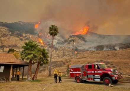
July brought the Dixie Fire in Northern California, and in August, California’s giant sequoias were caught in a series of fires. Santa Barbara dodged the fire bullet until this past Monday, when in cold, dry sundowner conditions, the Alisal Fire broke out for reasons as yet undetermined near a reservoir in the mountains above the Alisal Ranch a couple of miles outside Solvang. Winds blew it up and over the ridgeline, and by Wednesday morning, it had grown to 14,500 acres with only 5 percent containment.

Plaguing any attempt to fight the fire directly were the persistent wind gusts that sent tankers and helicopters back to base on Monday. As well, the Alisal’s fire front stretched across 10 miles of rough Gaviota terrain, an area riven by steep drops and knobby hills of rock, and thick with brush that has been growing for the 66 years that have passed since the Refugio Fire of 1955. Daytime humidity levels in the teens made the chaparral prime for the embers flying in the high winds, pushing the flames in all directions through an area that holds horse ranches, avocado orchards, homes, a landfill, and oil refineries.
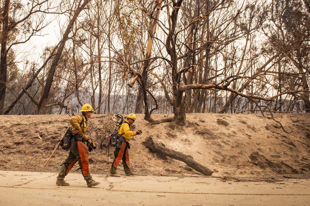
The fire was burning fast and erratically in areas very remote from accessible roads, said Captain Nikki Stevens, a spokesperson for County Fire, on Monday night. Firefighters were flanking the fire, getting at areas of opportunity, and focusing on structure protection for the roughly 300 people in its path. Crews on the ground were staying out of the path of the fast-moving burn, however, for safety’s sake. “We’re not putting anyone in front of it,” Stevens said. “This hasn’t burned since 1955.”
In the Wednesday-morning fire update, the incident command — which had moved with the fire from Refugio beach to El Capitán and is now at Earl Warren Showgrounds — announced 1,300 men and women were on a fire that had grown to 14,500 acres in size. The frisky winds of Monday and Tuesday were expected to let up and allow fixed-wing tankers to join helicopters in dousing the fire with retardant and water.
In a briefing to county supervisors on Tuesday morning, County Fire Chief Mark Hartwig said he was attempting to get his hands on as many aircraft as possible to beat back the fire. When the north winds finally began to abate later that day, five or six helicopters flew in to dump water on blazes in the steep canyonlands. By Tuesday afternoon, two fixed-wing aircraft were seen working the Santa Ynez side of the fire.

As the Alisal Fire moved to the south and east — it’s burning on the Pacific-facing side of the mountains and hadn’t burned on the Santa Ynez side since the fire started on Monday afternoon — mandatory evacuations for 270 residents were ordered in the Refugio area on Monday, and deputies from the Sheriff’s Office and members of Search and Rescue went door to door to ensure that residents were notified. By late Tuesday, evacuation warnings extended to Mariposa Reina to the west and Dos Pueblos Canyon Road to the east, affecting more than 260 people.
An evacuation center was set up at Dos Pueblos High School in Goleta, and animals were welcomed at Earl Warren Showgrounds. Kelly Hubbard, head of the County Office of Emergency Management, told the supervisors 18 people had come to the shelter the first night, 14 of them stranded Amtrak passengers and four of them area residents.
Monday also saw the closure of the main artery traversing coastal California, Highway 101. A detour around the 101 means motorists must take Interstate 5 or, locally, State Route 154, which is heavy with traffic and irritable drivers. The 101 closure at Gaviota was both for public safety — the fire and smoke make visibility very poor at times — and to allow fire engines and dozer crews to come and go quickly, said Jim Shivers, spokesperson for Caltrans, who added, “a big dose of patience is needed.”
Sign up for Indy Today to receive fresh news from Independent.com, in your inbox, every morning.
The movement of the fire eastward could bring it into the burn scar of 2016’s Sherpa Fire, which has since revegetated, but not nearly as thickly and densely as the terrain the Alisal Fire most recently traversed. With less fuel, the hope is the Alisal’s rate of spread will slow down significantly. “That will really help us with this,” Bertucelli said.
As in past fires, the mutual aid system has brought to Santa Barbara strike teams from Riverside, San Bernardino, Orange and Los Angeles counties, state Cal Fire resources, and Forest Service personnel from throughout the state, to name a few, Chief Hartwig told the Independent. All ranks of his firefighters are working the fire, with crews still keeping the fire stations around the county fully staffed. About 15 support personnel are out at California’s other extreme fires.
At the outset of the fire, which was called in on Monday just after 2 p.m., Hartwig said the command team mapped the key hazards to target for protection, “from approximately where it started near the Reagan ranch to the Tajiguas Landfill — which is just a hop, skip, and jump from West Camino Cielo — to the freeway, the railroad tracks, electric transmission lines, and the oil processing facilities.”
The fire had moved above Tajiguas Landfill by late Monday afternoon. Its $150 million anaerobic digester and recycling complex, just opened in July, were threatened, and mid-morning on Tuesday, its biofilter caught fire. In addition to the biofilter, which works to filter stinky air from the recycling building through several feet of damp woodchips, the fire roamed over the facility and may have damaged drainage systems, methane collectors, and heavy equipment, said Lael Wageneck, spokesperson for the facility. Key personnel were onsite and were safe, he said, and the indoor and outdoor fire-suppression systems worked to preserve the new Materials Recovery Facility, or MRF, and the digester system.
With the highway closed and the facility damage under evaluation, the county’s waste will be sent to Ventura County temporarily, said Wageneck, and the Transfer Station on Dump Road will stay open.
Also on Tuesday afternoon, the county supervisors held a special session to declare the county to be in a state of emergency, a declaration needed to start emergency funds coming from state and federal authorities since the county could soon be tapped out. The county’s emergency chops have been honed by past disasters, in particular the Thomas Fire, after which the county, nudged by Montecito residents, hired a FEMA expert. By Wednesday morning, the Federal Emergency Management Agency (FEMA) had approved a grant for up to 75 percent of firefighting costs.
Hartwig offered an idea of what the cost of fighting a widespread, multi-day fire could be. “One of the first trailers to set up at any command post is the finance trailer,” he said, with a wry laugh. That’s in addition to the command, operations, planning, logistics, and even map-making trailers. This fire fight, which looks to have started in Los Padres, is under the command of three agencies: the federal Forest Service, County Fire, and the state responsibility area normally tasked to Cal Fire but under contract to the county.
A huge fire requiring all ground, air, and support resources, like the Dixie Fire in Northern California, can run $2 million a day, said Hartwig. By comparison, the Alisal Fire could be costing about a half-million to a million dollars per day, an amount that quickly exhausts County Fire’s budget and whatever’s left in the county’s emergency fund after COVID.
As for red-alert zones like the landfill or Exxon’s facility at Las Flores, Hartwig felt the firefighters would be able to defend the Exxon refinery, as they had successfully during the Sherpa Fire. Wageneck indicated the fires at the landfill was under control.
Next door in Venadito Canyon, the fire tugged on trees and brush in the gullies and ridges abutting the Exxon facility, said Eric Hvolboll, who was working to protect his family’s La Paloma Ranch. “Thanks the several fire engines and hotshot crews from Nevada who have been here all day and still are,” he texted. Discussing the fate of Las Flores across the eastern ridge, he noted that parts of his canyon were burning a second time after Sherpa.
CORRECTION: The story was updated Oct. 13 at 2:15 p.m. to clarify that that evacuation warnings extended to Mariposa Reina to the west and Dos Pueblos Canyon Road to the east.
Support the Santa Barbara Independent through a long-term or a single contribution.


You must be logged in to post a comment.