
The plan to redraw maps for future city council elections — updated to reflect the latest census data — has flown largely under the radar, with the Independent Redistricting Commission meeting several times since November 2021, working with the community to create a map that would keep the core identities of each district while maintaining strong Latino voting populations in the Westside and Eastside districts.
Although the commission did not receive the flood of community-drawn maps that city staff had hoped for, there was enough community input for the group to confidently move forward with four final options.
City Councilmember Kristen Sneddon — who represents the Upper East, Riviera, and Foothill areas of District 4 — has been in the redistricting meetings, and said the commission has been “very responsive” to community input, but said “there hasn’t been much community input at all.”
All of the proposed maps — of which there were more than a dozen before being narrowed down to the final four — were either drawn by the city’s demographer, the National Demographics Corporation, under the direction of the commission, or submitted by political scientist Lanny Ebenstein for the Committee for District Elections.
In comparison, Carpinteria, which is undergoing its own move toward district elections, received hundreds of maps drawn by the community. For Santa Barbara: “Not a single one,” Sneddon said.
This could be due to the fact that the city made most of the major considerations in 2015, when it was forced by a lawsuit to make the move to district elections, whereas the latest redistricting is an update to reflect the latest census results.
Sign up for Indy Today to receive fresh news from Independent.com, in your inbox, every morning.
Of the four maps remaining, there are no major outliers, Sneddon said, or changes that would force existing councilmembers to run in another district — though some primary drafts would have drawn her outside of her District 4 boundary. The major differences lie in the changes for Districts 1 and 3, the Eastside and Westside areas with a majority Latino voting population.
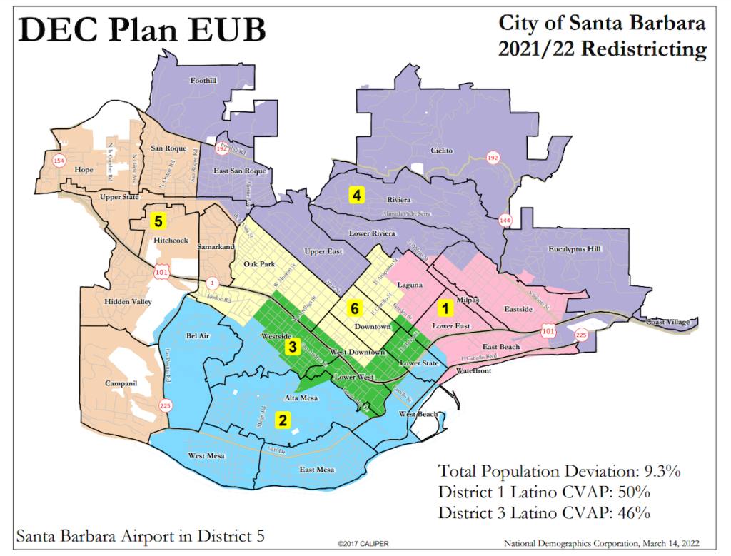
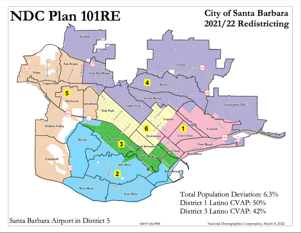
Perhaps the most radical of the new maps, she said, is the District Elections Committee’s “EU” map, which would extend Oscar Gutierrez’s District 3 across the freeway to include Castillo Street, and across lower State Street all the way to Garden. It would also extend Sneddon’s District 4 to include East Beach to the wharf.
“East beach belongs to the Eastside,” Sneddon said. Out of the four, she prefers the District Elections Committee’s other option, “EUB,” or the demographer’s “101RE,” which would preserve most of the districts as is, with a few blocks being changed in the Eastside and Westside to preserve the Latino vote.
Sneddon said she would be willing to work with either of the two, as long as both councilmembers Alejandra Gutierrez and Oscar Gutierrez are in consensus, since their districts would be most affected.
The commission will meet one more time, at 2 p.m. on March 30, where a final map is expected to be chosen. This hearing will be one of the last opportunities for the public to have input on the process. For more info, and detailed information on the four options, visit the commission website.
Support the Santa Barbara Independent through a long-term or a single contribution.


You must be logged in to post a comment.