
[Update: Jan. 10, 2023, noon] As of noon on Tuesday, January 10, this is the evacuation information at the county’s emergency information website ReadySBC.org:
EVACUATION ORDER in the following areas:
- Carpinteria Creek properties
- Montecito/Toro Canyon/Sycamore Canyon/Padaro Ln
- Serena Park area in Carpinteria
- Conejo Rd and Sycamore Creek properties in City of Santa Barbara
SHELTER IN PLACE in the following areas:
- Lower Eastside/Riviera in City of Santa Barbara
- Santa Barbara County impact areas (Cave and Alisal)
- Foxen Canyon/Santa Maria Mesa/Tepusquet areas in Northern Santa Barbara County
- Identified properties and areas in and around Carpinteria associated with the Thomas Fire
Read definitions for emergency protective actions to take for ORDERS, WARNINGS and SHELTER IN PLACE.
Click here to access the Santa Barbara County 2023 January Winter Storm Incident Map.
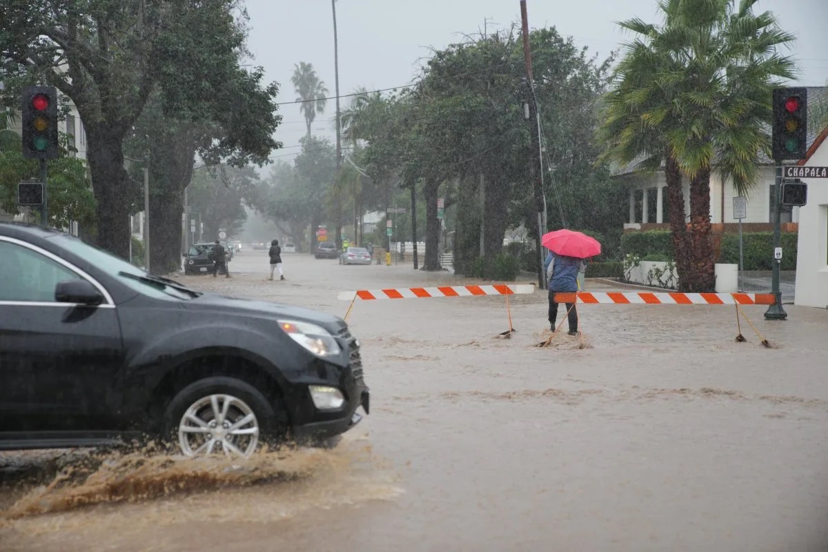
[Update: Jan. 9, 2023, 7:30 p.m.] The onslaught of rain is drowning low spots at on-ramps and off-ramps, with cars submerged at Milpas Street and San Ysidro Road, causing the ramps off the southbound 101 to be closed at those two roads, as well as at Winchester Road in Goleta. The 101 is now virtually impassable, as the lanes are closing just north of Ventura as the river is about to rise above the highway lanes, the California Highway Patrol reported.
The 101 northbound remains closed at Mariposa Reina, as it has been since early this morning, and also at the 33 in Ventura. The 154 across San Marcos Pass is closed, and State Route 33 and 150 between Ojai and the 101 are also closed.
For those who can, staying home is the best place to be. The City of Santa Barbara has added a shelter-in-place advisory for the lower Eastside and Riviera neighborhoods.
For those in the evacuation areas, be aware that downtown Santa Barbara streets are flooding below Canon Perdido Street. Submerged cars can be seen in some neighborhoods, and officials recommend staying out of flooded intersections, if only because manhole covers have blown off in some places. An updated list of road closures in the county can be found here.
[Update: Jan. 9, 2023, 7:20 p.m.] As of its latest update at 6:57 p.m. on Monday, January 9, Santa Barbara County had the following evacuation and shelter in place orders in effect:
- Evacuation Order: All of Montecito/Toro Canyon/Sycamore Canyon/Padaro Ln. Leave now.
- Evacuation Order: Serena Park area in Carpinteria. Flooding. Leave now.
- S.B. City Fire Evacuation Order: Conejo Rd. and Sycamore Creek properties. Leave now.
- S.B. City-Issued Shelter in Place: Lower Eastside/Riviera, Santa Barbara. Stay inside or go to high ground.
- County-Issued Shelter in Place: Santa Barbara County impact areas (Cave and Alisal). Go to innermost room or high ground. DO NOT attempt to leave. If already evacuated, remain out of the area.
Click here to access the Santa Barbara County 2023 January Winter Storm Incident Map.
The following highway closures are in effect:
- Northbound 101 closed at the 33, through Santa Claus Lane
- Northbound 101 closed at Winchester Canyon Road
- Southbound 101 closed at Milpas
- Expect flooding along sections of northbound 101 throughout Summerland &
Montecito, with intermittent closures and on/offramp closures - Highway 154 closed in both directions
Avoid travel if you are not in an evacuation order zone. Roads are flooded and dangerous. Check here for storm-related road closures.
Resources & Information:
-
- An Evacuation Center is open at the SBCC Wake Center, 300 N. Turnpike Rd, Santa Barbara.
-
- An Evacuation Center is open at the Veteran’s Memorial Building, 941 Walnut Ave., Carpinteria.
-
- For animal evacuation information, call Santa Barbara County Animal Services at 805-681-4332.
-
- For large animal evacuation assistance, please call 805-892-4484.
-
- For Evacuation Center assistance and additional information, contact the Santa Barbara County Call Center at 833-688-5551 or call 2-1-1.
-
- Click here to register for Emergency Alerts to receive any changes to protective actions.
[Original Story] Santa Barbara County Sheriff Bill Brown showed up to this Monday afternoon’s First Responders’ press conference poised to issue emergency evacuation notices to all people living in the burn scars areas of the Alisal, Cave, and Thomas fires. But because of intense rain events anticipated through the early evening — and the flash flooding predicted — he was forced to issue “shelter in place” orders for the entire county instead. With sudden flooding anticipated, Brown explained, it would not be safe to have so many people driving on county roads in full evacuation mode. But later — after the flash flood warnings had elapsed Brown said — the evacuation orders would be issued. The flash flood warnings are expected to elapse around midnight.
Welcome to the fifth anniversary of the January 9 Debris Flow disaster, which claimed the lives of 23 Montecito residents and destroyed or damaged 500 properties.
Highlighting the historic details, Montecito Fire Chief Kevin Taylor delivered a mini-history lesson detailing how the one-two punch of fire followed by rain has proved devastating in the extreme for county residents. Back in September 1964, Taylor stated, the Coyote Fire burned nearly 80,000 acres. On November 9, the burn scar of that fire was bombarded by exceptionally heavy rains, letting loose upon downstream residents a tower of mud and boulders 20 feet high moving at 15 miles an hour. In December 2017, he said, the Thomas Fire burned nearly 250,000 acres, setting the stage for the following month’s deadly debris flow.
But the real punch line, according to Taylor, happened five years after the Coyote Fire and Debris Flow. Between January 1 and 25 in 1969, he said, the South Coast received more than 20 inches of rain. On January 26, he said, it got more than six inches in less than 24 hours. In the subsequent debris flow, he said, Montecito lost five lives and saw 10 properties destroyed.
“Today, this is January 9, 2023,” Taylor stated. “We are exactly five years removed from the 1/9 event.” In the past 30 days, Taylor added, Montecito and the South Coast have received 20 inches of rain. Since 3 a.m. Monday, he said, no less than five inches have fallen.
“The community is at risk of a second debris flow,” he warned. Accordingly, Taylor said, 200 responders have been “pre-positioned” throughout the area. “Together, we will get through this event,” he declared, “and any other challenge Mother Nature may throw our way.”
Also speaking at Monday’s press conference was Eric Boldt of the National Weather Service. Throughout the day, he said 5-7 inches of rain had fallen in the foothills and mountains; two inches had fallen closer to the ocean. It wasn’t so much the quantity that got Boldt’s attention as the intensity. In one hour, as much as 1.25 inches of rain had fallen. By the time this series of storm cells are finished, he said, the foothills could get soaked with as much as “a foot” of rain.
That level of saturation coupled with gusting winds of as strong as 60 miles per hour on the mountains could topple trees. If they fall onto power lines, as they often do, that could cause power outages. He estimated this evening’s surge could last until 7 p.m. He predicted another intense pulse beginning early Tuesday morning and lasting until about noon.
Sheriff Brown warned that the storm system rolling through “had the potential to cause major problems,” especially in burn scar areas. In Montecito, he said, the Cold Spring and San Ysidro catch basins had already reached their carrying capacities; the runoff, he said, was causing flooding on Highway 101. He urged people to say off the roads if at all possible.
His deputies and search and rescue workers, Brown said, would be going door to door in evacuation zones, which as of this afternoon include all of Montecito, Serena Park in Carpinteria, and all campgrounds from Rincon to Gaviota. (The interactive evacuation map can be seen here.) People might hear from deputies speaking through their car’s PA system. He also pledged to maintain a highly visible law enforcement presence in evacuation zones to discourage looters.
Santa Barbara County Fire Chief Mark Hartwig said all the county fire agencies would be deploying a combined crew of 30 search and rescue experts trained in how to respond during swift water events. He warned residents to stay away from creeks. Waterlogged creek channels, he noted, were quick to collapse. His department had responded to one rescue event already, he said, up in Refugio Canyon. People who need rescuing, he cautioned, often underestimate the risk rushing waters pose. It takes only six inches, he said, to knock a person off their feet. Eighteen inches of water, he added, can carry a car downstream.
Chris Mailes, chief of the City of Santa Barbara Fire Department, said that the scarred hillsides above Loma Alta — the scene of a relatively small but very intense fire two years ago — were not at risk of debris flow or mudslides. He said a geologic examination of the soils indicated the ground was stable. “We do not anticipate a debris flow,” he stated. But just in case, he added, police and fire personnel would be deployed throughout the city’s lower Westside. If residents heard an unusual “high-low” siren, Mailes said, that would be the origin.
Mailes said city creeks were operating at about 50 percent capacity, though a few had breached their banks in spots. He said there was no indication of any issues in the “downtown core” other than significant water runoff.
In a separate interview, Santa Barbara Mayor Randy Rowse — not at the press conference — described being shown photos of jets of water shooting four feet into the air through city manhole covers. The city’s storm drain system, Rowse said, was overwhelmed by the sheer volume of water.
The city’s sewer system has been impacted as well. Five thousand gallons of raw sewage burst from city pipes by West Beach and got into the lower reaches of Mission Creek. West Beach has been declared off limits for sanitary reasons.
Rowse said he was relieved to learn that the tide has been going out Monday afternoon and that high tide is not expected again until 10:15 Tuesday morning. That’s significant because the low tides allow city creeks to empty out their loads into the ocean. With higher tides, the creeks are effectively blocked, and the water has no place to go but sideways and into the adjoining neighborhoods.
“This is a big one,” the mayor said.


