
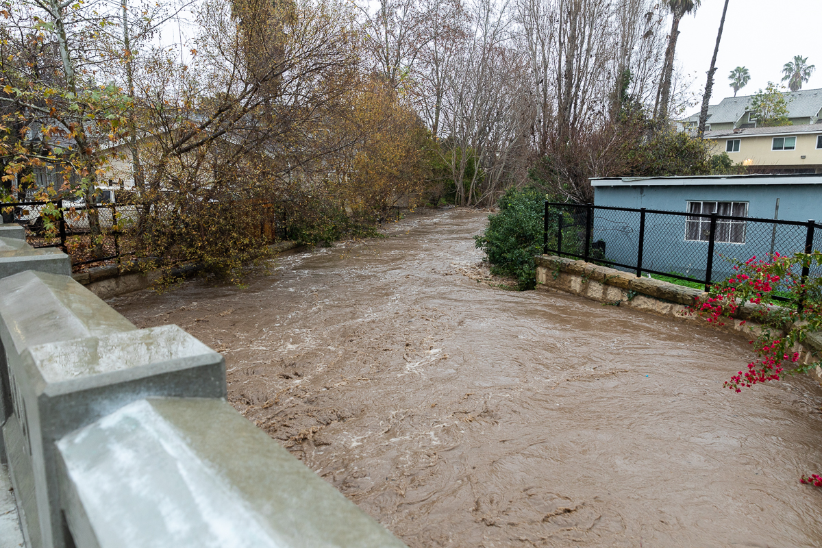
Heading into last weekend, local agencies met with the National Weather Service in preparation for what they expected to be a three-wave storm from Sunday to Tuesday, with the heaviest wave forecasted to drop 2-5 inches in the urban areas and anywhere from 4-8 inches up in the mountains. When the sky opened up and let loose more than 17 inches of rain on Monday — according to the rainfall meters at San Marcos Pass — it pushed the city’s public services into overdrive, with every arm of the Fire, Police, and Public Works departments scrambling to mitigate the damage.
Now, the city is assessing that damage, and in Thursday’s rescheduled City Council meeting, the heads of each of these departments provided an update on the storm impacts, which showed the city’s infrastructure pushed to its limits but safe from catastrophic failure. Most notably, no deaths or injuries were reported in the hundreds of rescues over the weekend, and no houses or structures were damaged beyond repair.
“I just can’t say enough about the amazing work that everyone did as a team here in the city during this event,” said Santa Barbara Police Chief Kelly Gordon, who reported that the department responded to at least 160 storm-related calls — including 20 calls for people who could not locate loved ones and 49 for active flooding — from Sunday to Tuesday. ”During this event, a lot of things changed, and we had plans and quickly had to change plans because now the water was rising quicker than expected.”
Fire Chief Chris Mailes explained just how quickly the plans changed. He recounted that going into Monday’s 11 a.m. emergency press conference, “Flood control and creeks were at 50 percent and functioning well” and Montecito had elected to evacuate “a couple of zones” based on risk. Then during the meeting the rain really started to fall.
“Within no more than five minutes, the intelligence that we were getting out of the Montecito community was that this was much more than anticipated, and that’s when all 15 zones of Montecito were told to evacuate,” Mailes said. “So that time, between 11 and 12 o’clock, we had a dramatic shift in the weather and much more intensification of the storm.”
Monday afternoon saw the bulk of the rainfall and the bulk of the damage across the city. Soon, city creeks were flooding, Mailes said, and the Mission Creek flood control channel began to crest.
A 30-person regional search-and-rescue task force was put in place, and the Fire Department responded to hundreds of calls for services, many of which were rescues of people trapped in vehicles.
Weather agencies originally expected that Monday night would bring the third wave, with thunderstorms and winds anywhere from 50-70 miles per hour, but those storms never materialized in Santa Barbara and instead passed just north of the city between Santa Ynez and Los Alamos.
Had the winds materialized around the freshly saturated trees, Mailes said, “We would’ve had a completely different problem on our hands with trees down.”
Sign up for Indy Today to receive fresh news from Independent.com, in your inbox, every morning.
The city’s waterfront and harbor also survived any major damage, according to Waterfront Director Mike Wiltshire, who said all businesses except the Santa Barbara Yacht Club were open as of Thursday. Stearns Wharf also held up well, which Wiltshire said was “a testament to a wharf that’s been there 150 years and it’s got more left in it.”
Large swells destroyed the sand berms along the beaches, and waves reached the Yacht Club. Though the structure had no issues, Wiltshire said, the Yacht Club “did see some pretty serious impacts” to plumbing, HVAC, and utilities that run on the underside of the building.
The biggest impact was the harbor entrance, which saw “roughly a year or two’s worth” of sediment move into the harbor entrance in a period of 48 hours. “So our harbor entrance is extremely shallow right now,” he said. “It’s essentially hazardous to navigate.”
Crews will begin an emergency dredging on Friday, and Wiltshire said that since all sand berms were destroyed it was important to get some sort of protection up before the next storm swells.
Public Works Director Cliff Maurer reported that the city’s water distribution system “far exceeded expectations,” with only one water main break on the Eastside near Voluntario Street.
Stormwater drains were pushed to their limits on Monday, with several manhole lids blowing off from the pressure of the flooding waters. “With that level of intensity, there’s nothing that can be done,” Maurer said. “It’s unfortunate, but that’s the reality.”
All roads and bridges in city limits are structurally sound, Maurer said, and no homes were “red-tagged.” Five houses were “yellow-tagged” along North Calle Cesar Chavez, meaning the building was damaged but tenants would not be forced to leave. Occupants of at least one residence near Castillo and Bath near the Mission Creek crossing reported that they felt their home was uninhabitable.
Storm water entering the city’s wastewater systems pushed El Estero Water Treatment Plant to its limits, with water flowing at a rate of 34 million gallons per day — nearly six times the plant’s usual average rate of six million gallons a day. Despite being at its maximum capacity, the plant only had “minor mechanical problems,” Maurer said, which were all fixed by the next morning.
From a community standpoint, hundreds of cars were left abandoned and thousands of people were placed under evacuation order over the weekend, but city officials felt that the agencies worked well together to communicate with the public and provide resources.
The recovery effort, Assistant City Administrator René Eyerly said, would be “just as resource-heavy and critical as response,” since there are more than 40 counties in the state that will be seeking help from the federal government due to storm impacts.
Here in the city, a local assistance center will be opened at the Eastside Library to provide bilingual workshops, resources, and individual case management to the local community.
Looking forward, the National Weather Service is projecting two waves of rain over the weekend, though Fire Chief Mailes said that it is expected to be much lighter than last week. The first wave is expected from Friday night into Saturday and the second from Sunday night into Monday, totaling 1.5-3 inches of rain.
“They are not expecting to have to issue any flash-flood advisories or watches with this,” Mailes said.
Support the Santa Barbara Independent through a long-term or a single contribution.


