
The Rock Garden
A Loop Hike to Die For; Though Challenging It Leads to Unimagined Inspiration

TRAIL INFORMATION
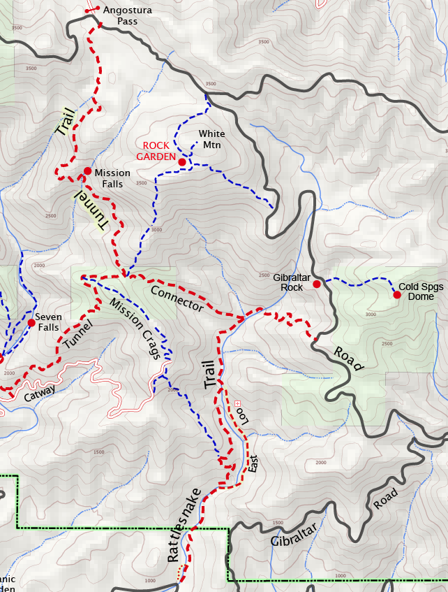
Distance-0.5 to the Rattlesnake Connector; 1.25 miles to the Tin Can Shack; 2.25 to the intersection with Tunnel Trail; 3.0 to the Rock Garden; 5.0 back to the car.
Elevation Gain-800-foot loss to the Tin Can Shack; 600-foot gain to the intersection with Tunnel Trail; 1,950 feet to the Rock Garden; 1150-foot loss back to the car.
Difficulty-Strenuous to the Tunnel Connector; hard core for the loop.
Topo– Santa Barbara
View Gallery 1 | View Gallery 2
HIGHLIGHTS
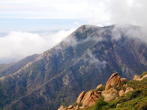
This hike provides one of the most challenging and spectacular loops you will find anywhere in the Santa Ynez Mountains. This loop description combines both trail hiking and off-trail scrambling, taking you down into Rattlesnake Canyon to the historic Tin Can Meadows, then sharply up the connector to Tunnel Trail. An off-trail route takes you straight up a ridgeline to one of the most spectacular boulder fields in these mountains. The Rock Garden can also be accessed from Tunnel Trail or the top of the mountains near the East Camino and Gibraltar intersections.
DIRECTIONS
From the Santa Barbara Mission drive up Mission Canyon Road to Foothill and turn right. Continue past the fire station. At the stop sign turn left onto Mountain Drive, follow it up to Sheffield Reservoir, turn left again and head straight uphill, continuing on until you reach Gibraltar Road. Park at the Gibraltar Rock climbing area, approximately five miles up the road.
SETTING THE SCENE
While most hikers tend to start their hikes in either Rattlesnake or Mission canyons from the lower trailheads, an often overlooked route into the upper ends of both of these canyons can be made from Gibraltar Road. Whether you are visiting the upper meadows in Rattlesnake Canyon or continue up the connector to Tunnel Trail, this is a very pleasant starting point and most likely you will see far fewer people.
I find this a nice alternative route to Mission Falls. One of the bonuses, too, is the opportunity for watching the evening sunset from atop Gibraltar Rock at the end of your hike. When my friend Bob Hardy and I drove up Gibraltar Road one fine winter morning, we weren’t heading to the falls however. We were looking to see if it would be possible to make a loop hike via the Rock Garden, which we had discovered on a previous trip. The description that follows chronicles the hike.
THE HIKE
It was 8:30 a.m. and cold but that was okay-we both knew we would be doing a lot of uphill climbing and we didn’t want to lose any more perspiration than we had to. Gibraltar Rock was deserted when we pulled off the road and parked. We had decided to park here because it would allow us to split up the road walking.
We knew it was possible to hike down into Rattlesnake Canyon, take the connector up to Tunnel Trail, then make our way up to the Rock Garden, but we weren’t sure if we could find a way from the Rock Garden on over to the upper end of Gibraltar Road. In our minds we were sure we could, but there were no guarantees.
In any case, we would have to walk at least a mile or so back down the road. Rather than parking right by the Rattlesnake Connector we decided to park further up, allowing us to do a little road walking at the start and another stretch of it at the end, rather than all of it at the end. Afterward we both agreed this was the nicest way to do it.
Ten years ago you would have seen a trail sign marking the start of the Rattlesnake Connector but there isn’t one there now. Most likely you’ll miss it when driving by, but we didn’t have any problem spotting the trailhead walking down the road. We were still in the shade and it was crispy. However, the three-quarter mile walk from the climbing area down to the connector didn’t take too long.
The trail switches back and forth on the shade side of a small ridge, dropping several hundred feet. At the end of each of the turns Gibraltar Rock and the upper canyon were clearly visible. A half mile of hiking brought us down into the canyon. Crossing the creek we headed down the right side of Rattlesnake Canyon and within a few minutes we were at the connector leading up to Tunnel Trail. What a nice way to visit this part of the Rattlesnake wilderness area. Tin Can Meadows is just a few yards around the corner.
We stopped for a few minutes under the oak canopy, resting on one of the large boulders there, stretching our legs for the uphill that faced us. The connector is short and sweet, a steady uphill that takes you up 600 feet in elevation in just over a half mile of walking. A half hour later we were up at the saddle, taking another rest break, and getting ready for the big climb up the ridgeline to the Rock Garden.
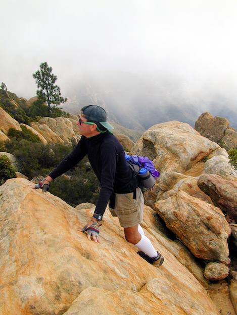
The climb up to the top was tough, though not nearly as difficult as we thought it might be. Ducking under the chaparral which nearly covered the hidden trail, we were soon working our way almost directly up the ridge. An hour later we were in the boulders, having lunch, admiring the views, and sharing a few thoughts about the hike up.
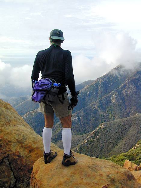
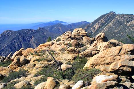
The Rock Garden is at the apex of the high peaks on the right side of Mission Canyon, separating it from the Rattlesnake area. From town, its craggy face isn’t quite as impressive as the pyramid-shaped peak leading up to Cathedral Peak; nevertheless, once you are up here at the top it is spectacular. The crest here has weathered more, forming a wider, more open area, several hundred acres in size, with all sorts of shapes formed in the sandstone.
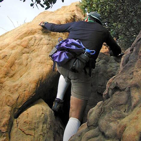
As we explore in and out of the cracks and crevices I spot one thin, 30-foot high slab with bolts attached to it. The climbers have been here. It is a fairyland of mazes. The manzanita is waist high, making the travel through it relatively easy and there have been enough people up here to create small paths.
Bob and I spent an hour exploring the garden before we came to the moment we had been wondering about: the time when we would find out if we could make it over to Gibraltar Road without having to go back the way we had come. It turned out not to be too difficult.
As we headed east through the boulder and manzanita-covered hillsides we began gaining elevation. The Rock Garden is not the high point of this peak; it is a quarter mile away on a nondescript chaparral hill. As we made our way toward the hill we discovered the problem wasn’t whether we could find a trail-it was that there were too many. Within a short distance we passed several intersections, each with small trails leading off into the chaparral.
Confused, we decided to try the one leading to the high point, thinking it might continue over to the road. A surprise awaited us at the peak, where the trail suddenly ended. Attached by a 4×4 pole anchored solidly in the ground was a beautiful wooden sign proclaiming this to be “White Mountain.”

Tracing our way back down we finally found a small trail leading in the direction of Gibraltar Road. The route dropped quickly, the first half switching back and forth through the rocks and manzanita and the second half a tunnel of taller chaparral. Within 20 minutes we were on the road, at a point not too far from the area where hang gliders and parasailers begin their precipitous drops down off the mountain wall.
The walk back down to the car took about 30 minutes and, though quite different from the hard-core hiking we had been doing for the past four hours, it was actually quite a treat to walk along it, stopping here and there, looking back up at what we’d done-and savoring those moments and reminiscing about them all the way back to the car.


