On the Road – Water, Water Everywhere
Massive Storms Cause Rivers to Overflow

Fayetteville, Arkansas. I opened the curtains to a welcome sight the next morning – clear skies. After 36 hours of never ending rain, I was looking forward to getting on the road again – to get an in depth look at the Ozark Mountains. The plan was to work my way here and there through the Ozarks with the goal of getting close to the Mississippi River.
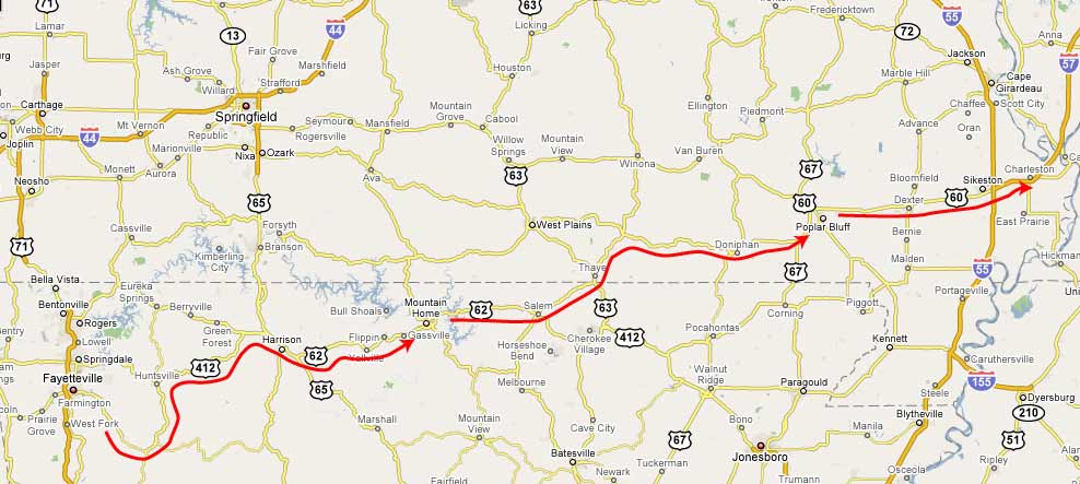
The drive up the White River valley out of Fayetteville was recommended to me by a couple from Indianapolis I’d met at Bryce Canyon. Heading up State Highway 16 I could see why they liked the area: this was a wide river valley with scattered farms, old stone houses, wooden barns and hillsides full of hardwoods that were just getting the first buds on the tips of their branches.
The river was flowing high and I could see why residents downstream were concerned but it was only later that I realized the concerns weren’t about today’s flooding but what would come 3-4-5 days later when the river began to crest. In my ignorance, I enjoyed the beauty of the moment as I cruised up the river.
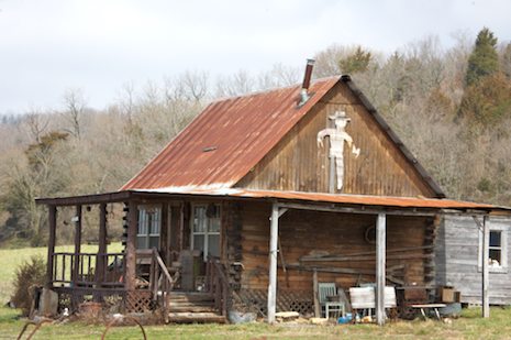
A half hour later I turned off the White and headed up over the crest of a low pass into another valley, this one heading north, past a small cabin marked by the words Hillbilly Cabin on an ancient truck just outside it, more lush valley scenery and plenty of side creeks full of boiling brown water.
Scenery such as this were the norm the rest of the morning and into the afternoon as I continued to twist and turn my way through the Ozarks – and a succession of towns small enough not to have made it on the maps. Just before I reached Mountain Home I drove through Gassville, Arkansas. Like Greensburg in Kansas, it had been hit hard by a tornado just last month (February 5, 2008). Still, one person had died and quite a few houses were destroyed. Despite the springtime beauty it was becoming clear to me that living out in the mountainous outback of the Ozarks was an exceedingly tough thing to do.
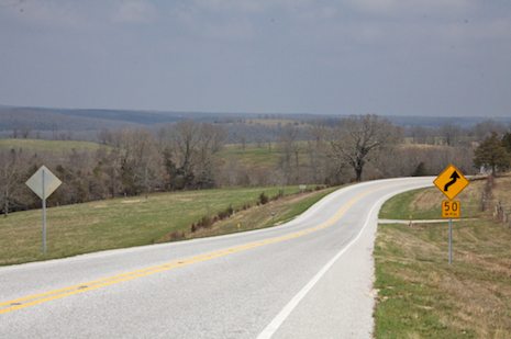
Not too far past Mountain Home I turned north on Highway 101 and crossed into Missouri. I had a choice of two routes east: highways 142 or 160. Both headed almost due east but since Highway 142 showed as the skinnier one on the map I decided to take it. The scenery was spectacular, with rolling grass covered hills and more wide open spaces than I’d seen in a while. The drive was mesmerizing, the road windy enough to keep me alert but the curves just gentle enough to allow me to flow along at a leisurely 35 mph with barely the need to touch the brakes.
I’d probably covered a hundred miles like this, through Moody, Lanton, Thayer and Gatewood and was looking forward to cutting back up north to Highway 160 and on that to Poplar Bluff when I passed by the kind of sign I wasn’t used to seeing. “Road closed ahead 3 miles,” it read. Below this were the words, “Local Traffic Only.” Nothing more, no hint of what the problem might be. This concerned me a bit because I wasn’t sure how far I’d have to double back if I couldn’t get through.
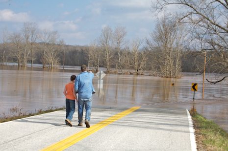
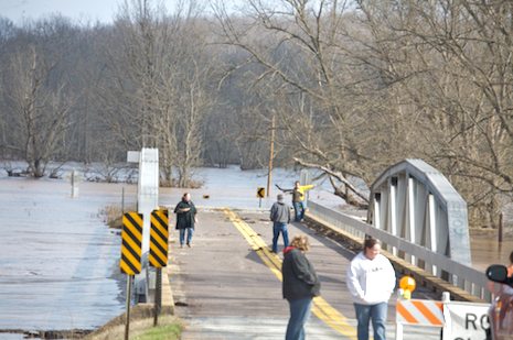
Was it a bridge out? A creek overflowing its banks? Mud on the road? Not only curious enough to want to find out but stubborn enough too that I’d at least see if there was a way through before heading back. The road twisted its way down a long grade with enough curves and thick trees along the roadside to hide whatever the problem was. Ten minutes later I made the final curve, hit a short straight away and there it was, not a bridge out exactly because I could see a few locals walking out and across it. But beyond that all that could be seen for at least the next half mile was water.
Timidly, I made my way out to where several others were standing, looking out across the wide expanse. Together, we walked across the bridge to the small patch of terra firma on the other side. Then beyond that the road disappeared, the yellow strip marking this a “no passing” zone fading into the dark brown water.
“Son of a bitch,” I thought? And the thoughts started creeping in – am I trapped? So what if I find a route up and around, will the next bridge north be out too? What about the Mississippi? What if I can’t get across that?
Then from behind me one of the locals that was down checking out the damage called out to me, “How’d you come across those California plates? We don’t see too many of those down here.” Turns he and his wife Tammy were California transplants from Barstow who’d come here to buy a small farm and enjoy their retirement years. “Amazing, isn’t it,” Jim told me as he pointed out towards the bridge. “We floated under that bridge in our canoe not too long ago and now you can’t even see the banks. Yesterday those yellow road signs were under water too. So was the bridge so the water’s gone down quite a bit.”
We talked for a bit longer then Tammy pointed out the fact that there was a cross road that would get me over to Highway 160 a few miles back. “It’s got a road closed barrier across it but I just talked to a guy who’s been through so you can make it.”
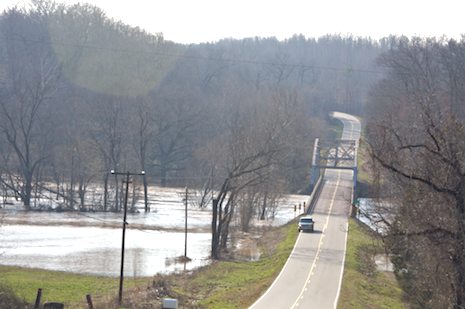
It turns out that there was just one creek crossing that had caused the closure and that was passable so I was OK all the way to the 160 but not too far east I knew I’d need to cross the same river that had just cut me off downstream. Thankfully the valley was narrow here and the bridge much higher above the river – though not too much – but enough that I was able to get through.
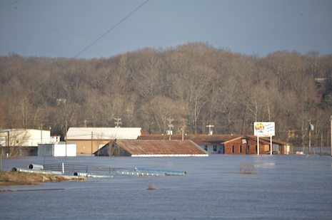
From this point to Poplar Bluff was another half hour’s drive and most of this was uneventful until I got near the town. While much of it was indeed up on the high bluffs overlooking the Black River, a good portion of the farmland and business section wasn’t, and much of this was underwater. Just as I’d thought the worst was behind me I could see “Highway Closed” signs and barriers ahead, with traffic being diverted off onto a side road.
Panic set in again but as I reached the state highway patrolman that was directing traffic I asked him if there was a way through. “Not on the parkway,” he told me. “There’s water across it a mile ahead but you can take the business route through town and get around it.”
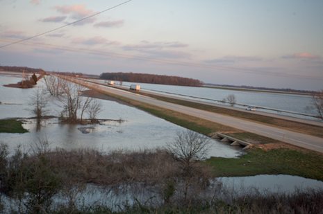
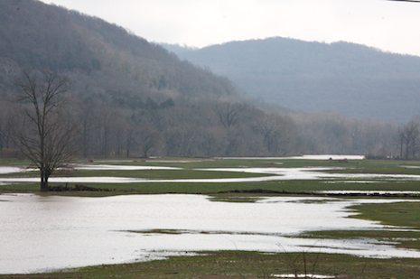
Fortunately I was but as I made my way towards Charlestown it was difficult not to be apprehensive. Though the parkway was a good eight feet above water level, there was nothing on either side for miles except water, water everywhere.