

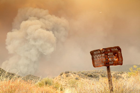
On Monday it was anybody’s guess which way the Rey Fire would head. During the first few days of the fire, now marking its fifth day, Rey expanded to the northwest, in the process blackening close to 10,000 acres of Rancho San Fernando Rey, before burnout operations succeeded in containing that part of the fire. Over the past two days, the fire took a 180-degree turn and is now spreading east and north, with the potential to pose a direct threat to South Coast communities and to char large portions of the Dick Smith Wilderness. The wilderness area holds major portions of the watersheds to the north of Lake Cachuma.
From the news releases posted by Los Padres Forest officials, it is difficult to get a clear picture of what has burned or what might in the coming days. Yes, the fire is now burning into the Dick Smith Wilderness and for the most part away from the coast. That is good news. The bad is that continued drought, incredibly dry brush, and temperatures that again soared into the 90s yesterday have created the potential for the Rey Fire to expand much further to the interior and toward Highway 33 than one would have thought possible just two days ago.
The wind has played a major factor in determining where the fire will go and what opportunities firefighters will have to contain it. On Saturday night, when the wind shifted to the east, bringing the fire swiftly down onto the Upper Oso Campground area, it effectively helped secure the west side of the fire. But at the same time it opened the door for the fire to jump Oso Canyon and head east — a situation that could ultimately lead it over the Santa Ynez Mountains and down into Montecito or Santa Barbara.
A Push to the East
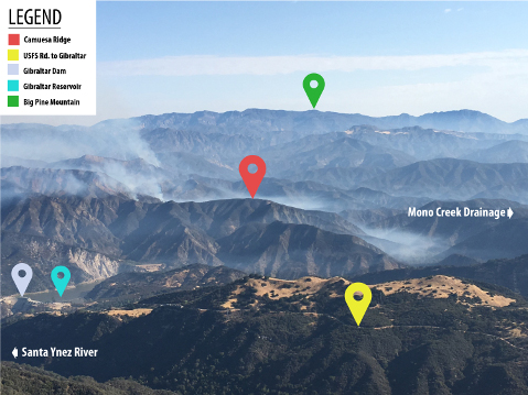
By mid-morning on Sunday, it was clear that the fire would brush past the White Fire scar and continue east. By noon a massive front had built, with flames centered just north of the ridges that line the river canyon, stretching from Oso to the Red Rock area. By 1 p.m. that front continued to push east down Camuesa Canyon, and the fire was in danger of crossing the Santa Ynez River near the upper end of Gibraltar Reservoir where Camuesa Creek merges with the river. From that point, the fire would have been within reach of the northern slopes of the mountains that separate the valley from the coast, a long, steep escarpment that has not burned in recorded fire history.
Just after 1 p.m., however, a northeast wind began to pick up, keeping the fire well away from the river. The wind did three major things: It kept the flames from reaching the Camuesa Ridge and allowing the fire to enter the river drainage; it stopped the eastward progress of the fire just short of Camuesa Peak; and it provided needed time for the aerial assault to lay down enough retardant to protect the river corridor.
Monday Blowout
At the incident center at Live Oak Camp on Sunday night, firefighters were told the major focus for Monday would be holding the fire from crossing Mono Creek. By this time the fire was active from the Camuesa Ridge area north beyond a series of cliffs known as the Chalk Bluffs to an area just east of Little Pine Mountain. By sunset the fire was burning down into Buckhorn Canyon and heading directly toward Indian Creek. The Mono drainage lies just beyond Indian Creek, and it was questionable whether it would be possible to meet that goal.
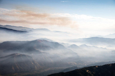
At 8 a.m. Monday morning, driving along the crest of East Camino Cielo, lots of smoke could be seen hanging in the maze of backcountry canyons, but only two small areas showed active fire and small plumes. One of those was on the east side of Camuesa Peak at a point where the creek makes a sharp turn and intersects the Santa Ynez River; the other was further to the interior in Buckhorn Canyon. Both seemed fairly benign. Things actually seemed pretty calm.
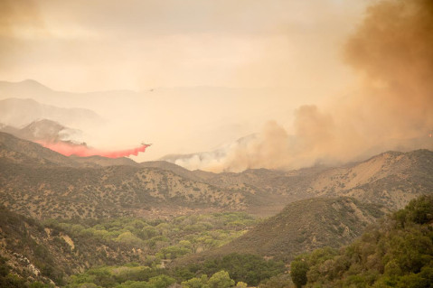
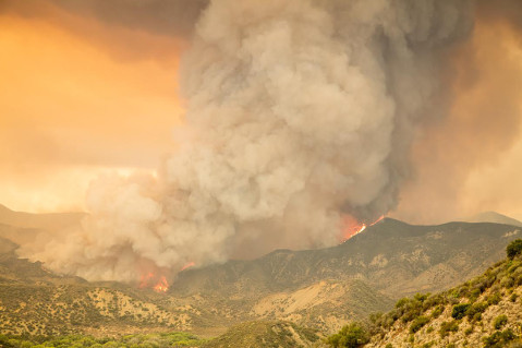
By 9 a.m. most of the smoke in the Camuesa drainage was gone, but the plume in Buckhorn Canyon was starting to build as the temperatures climbed into the 80s. By 10 a.m. the fire there had morphed into a major column of fire and smoke. Fortunately the canyon winds were blowing west, checking its progress somewhat. By this time the aerial attack had begun with thousands of gallons of retardant laid across the east side of the column. For the moment, between the retardant and wind, the fire column was held in place.

From the Ground
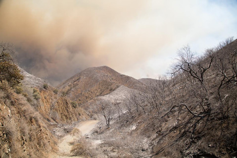
Down in the Camuesa drainage, from a viewpoint along Camuesa Road looking directly up to Camuesa Peak and north over the ridge toward Buckhorn Canyon, the devastation was evident. Sunday’s fire burned so hot that sections of Camuesa Canyon were down to mineral soil. The wind that had checked the fire the night before had also helped stop it just a quarter of a mile from the point where it would have burned to the river; if it had reached that point, the city would have been in peril. With a number of hot spots still sending smoke into the sky and occasionally flaring up, that potential still existed.
To the north, the column continued to burn, growing larger by the minute. The aerial drops continued, and the wind direction provided additional help. But then, about 1:45 p.m., the wind shifted, and the fire began to move. A cool breeze began to build, gusting 10-15 mph, an eastern wind that turned the column of smoke toward Indian Canyon. With the fire becoming more active, it was time to retreat back to the safety of a high promontory overlooking lower Mono Creek near the Debris Dam. A quick stop by the trailhead into Indian Canyon provided the first direct look at the front edge of the fire as it approached the canyon just after 4 p.m.
By 5 p.m. the front had expanded to a width of more than a half-mile. Spot fires began to appear across Indian Creek and burned up toward the ridgeline separating Indian from the Mono drainage. Then the front crossed and within minutes the fire climbed the 1,200-foot ridge, with flames easily over a hundred feet in height. Questions about how difficult it will be to contain the fire here began to surface.
Planning for Tomorrow
From the overlook, the Division P crew huddled in an effort to plan out tomorrow’s operation. The containment line had now shifted. The goal now: the ridge east of Mono Creek where dozers were cutting an eight-blade-wide line along the edge of the Hildreth Jeepway in the effort to check the fire there.
The focus was also on holding along the Santa Ynez River and making improvements so that crews would be able to burn out from the river if needed. With virtually no water in Gibraltar Reservoir and steep cliffs from the dam up river, the firefighters were struggling to find a way to anchor off the river. Along with the difficult terrain, sensitive species, such as a bird called the least Bell’s vireo, in the drainage added to the problems facing them.
Further to the Interior
At 7 p.m., the front that had crossed Indian Creek a few hours earlier had died down. Beyond, several miles up Indian Creek and in the vicinity of the point where Buckhorn Canyon enters the bottom edge of the Dick Smith Wilderness, another major column was building. On the drive out from the upper Santa Ynez River area that evening, major fire activity was evident that will surely take the fire much deeper into the wilderness area. Just across the mouth of Buckhorn Canyon is the Pie Canyon Jeepway, a steep, winding roadway that leads several miles over to the Ogilvy Ranch area.
Depending on wind direction, on Tuesday the fire could head into Mono Creek in multiple locations as well as burning even deeper into upper Indian Creek. There, the fire will be entering into the 2007 Zaca Fire scar. It is not clear if this will stop the fire or not. Monday, with hours of aerial assault on the front edge of the fire that pushed across Indian Creek, one firefighter said that it “walked right over the retardant as if it was never there.”
Along with the explosive potential for the Rey Fire to expand even further east and into the wilderness, there are currently no resources available to work the northern part of the fire. Even if those resources became available, it is questionable how successful they might be given the difficult terrain; there are few spots from which to hold the line when the fire burns like it has the past two days.
Press Conference Tuesday
Fire officials — including Bob Baird, Los Padres National Forest Supervisor; Chief Eric Peterson, Santa Barbara County Fire; and CalFire officials — will be holding a press conference at the Vista Point along Highway 154 to discuss fire update, major considerations, and forest restrictions and closures. Many questions need to be asked and answered; among the issues are resources, contingencies, and weather patterns.


